TopoQuest Logo
Do you find TopoQuest useful?
Help keep TopoQuest running and adding new maps/features by donating!
Bitcoin:  19c7KJd3qBynnjoSw5npx9KScwjBe4ifkT
Litecoin:  LXs6TkuXGGXo1vDsWCkWVdjQX94eUKd6ui
Home View Maps Find Maps Find Places Resources & Links


Nichols Knob, Missouri Topographic Map

USGS Map Title: Nichols Knob, MO
USGS Map MRC: 36092H2
DRG (GeoTIFF) Download: o36092h2.tif


Neighboring USGS Topographic Map Quads:


  Mountain Grove South, MO  
37092A3
 

  Cabool SW, MO  
37092A2
 

  Cabool SE, MO  
37092A1
 

  Vanzant, MO  
36092H3
 

  Nichols Knob, MO  
36092H2
 

  Dyestone Mountain, MO  
36092H1
 

  Gentryville, MO  
36092G3
 

  Dora, MO  
36092G2
 

  Siloam Springs, MO  
36092G1


Map MRC Location:

N37°
W93°
N37°
W92°
H8 H7 H6 H5 H4 H3 H2 H1
G8 G7 G6 G5 G4 G3 G2 G1
F8 F7 F6 F5 F4 F3 F2 F1
E8 E7 E6 E5 E4 E3 E2 E1
D8 D7 D6 D5 D4 D3 D2 D1
C8 C7 C6 C5 C4 C3 C2 C1
B8 B7 B6 B5 B4 B3 B2 B1
A8 A7 A6 A5 A4 A3 A2 A1
N36°
W93°
N36°
W92°

Nichols Knob, MO USGS 1:24K Topographic Map Preview:
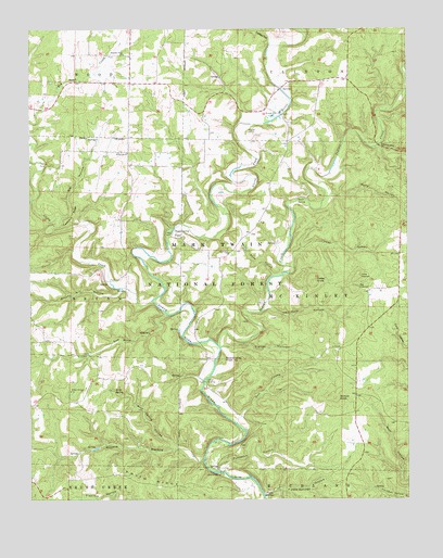
Nichols Knob, MO USGS Topographic Map
Click on map above to begin viewing in our Map Viewer.

This topographic map contains these locations and features:
Feature Name Type Latitude Longitude GNIS ID View Map
Big HollowValleyN36.9503°W92.2399°748837View Map
Big YoemanSummitN36.9306°W92.1427°748854View Map
Biggs (historical)Populated PlaceN36.9126°W92.1915°733885View Map
Bittick CemeteryCemeteryN36.9725°W92.1774°748873View Map
Brushy Mill HollowValleyN36.9306°W92.2196°749074View Map
Cedar KnobSummitN36.9328°W92.1565°749307View Map
Clifty CreekStreamN36.9278°W92.2096°749388View Map
Clough HollowValleyN36.9153°W92.1868°749389View Map
Coble School (historical)SchoolN36.9542°W92.2218°734209View Map
Creasy HollowValleyN36.9970°W92.1690°749514View Map
Dell HollowValleyN36.8967°W92.1807°749619View Map
Dimcher HollowValleyN36.9684°W92.1346°749662View Map
Duffy HollowValleyN36.9559°W92.1496°749742View Map
E - 76 - EE Volunteer Fire DepartmentBuildingN36.9862°W92.2061°2621372View Map
Fiddle SpringsSpringN36.8771°W92.1699°749911View Map
Fiddle Springs HollowValleyN36.8764°W92.1721°749912View Map
Fieldstone ChurchChurchN36.9673°W92.2174°749918View Map
FlorillaLocaleN36.9762°W92.1660°740497View Map
Florilla Post Office (historical)Post OfficeN36.9762°W92.1660°759935View Map
Hale CrossingPopulated PlaceN36.8823°W92.1874°750192View Map
Hell Hole HollowValleyN36.9264°W92.1713°750282View Map
Holt SchoolSchoolN36.9937°W92.2252°734206View Map
Holt StoreLocaleN36.9856°W92.2165°734207View Map
Hoots SpringSpringN36.9549°W92.1614°750386View Map
Indian CreekStreamN36.9162°W92.1877°750455View Map
Jim Coble HollowValleyN36.9548°W92.2490°750508View Map
Johnson School (historical)SchoolN36.9873°W92.1646°733884View Map
Little YoemanSummitN36.9339°W92.1415°750807View Map
MainardLocaleN36.8812°W92.1479°740498View Map
Mainard Post Office (historical)Post OfficeN36.9145°W92.1479°759941View Map
Mint SpringSpringN36.9037°W92.2230°751125View Map
Mint Spring HollowValleyN36.8889°W92.2018°751126View Map
Mount Ararat ChurchChurchN36.9406°W92.1838°751169View Map
Mount Ararat SchoolSchoolN36.9453°W92.1771°734210View Map
New Arlyn School (historical)SchoolN36.9917°W92.1440°734213View Map
Nichols KnobSummitN36.9020°W92.1490°751312View Map
Omba StoreLocaleN36.8867°W92.1946°734212View Map
Osborn CrossingPopulated PlaceN36.9064°W92.1924°751450View Map
Peas HollowValleyN36.9373°W92.1632°751531View Map
Phlegeton (historical)LocaleN36.9867°W92.1474°740496View Map
Phlegeton Post Office (historical)Post OfficeN36.9867°W92.1474°759943View Map
Pleasant Home ChurchChurchN36.9934°W92.2182°751665View Map
Prairie HollowValleyN36.8856°W92.1932°751748View Map
Punchout HollowValleyN36.8828°W92.1879°751776View Map
Round Valley KnobSummitN36.9131°W92.1865°751975View Map
Round Valley School (historical)SchoolN36.9045°W92.1721°733886View Map
Round Valley School (historical)SchoolN36.9073°W92.1949°734211View Map
Sam Wood HollowValleyN36.9239°W92.2052°752020View Map
Shad HollowValleyN36.9348°W92.1696°752085View Map
Smith RidgeRidgeN36.8795°W92.2107°752224View Map
Toothpick RidgeRidgeN36.9509°W92.2354°752560View Map
TopazPopulated PlaceN36.9456°W92.2029°752561View Map
Topaz SpringSpringN36.9463°W92.2018°752562View Map
Township of McKinleyCivilN36.9263°W92.1462°766626View Map
Willow Springs ChurchChurchN36.9039°W92.2368°752923View Map
Woods StoreLocaleN36.9806°W92.1988°734208View Map
Y ChurchChurchN36.9153°W92.1471°752990View Map

Note: Coordinates in the location and feature list above are referenced to NAD83 datum.


Copyright (C) 2008-2025 Ryan Niemi / Sunset Dynamics ... All Rights Reserved