TopoQuest Logo
Do you find TopoQuest useful?
Help keep TopoQuest running and adding new maps/features by donating!
Bitcoin:  19c7KJd3qBynnjoSw5npx9KScwjBe4ifkT
Litecoin:  LXs6TkuXGGXo1vDsWCkWVdjQX94eUKd6ui
Home View Maps Find Maps Find Places Resources & Links


Pomona, Missouri Topographic Map

USGS Map Title: Pomona, MO
USGS Map MRC: 36091G8
DRG (GeoTIFF) Download: o36091g8.tif


Neighboring USGS Topographic Map Quads:


  Dyestone Mountain, MO  
36092H1
 

  Willow Springs South, MO  
36091H8
 

  Trask, MO  
36091H7
 

  Siloam Springs, MO  
36092G1
 

  Pomona, MO  
36091G8
 

  White Church, MO  
36091G7
 

  Pottersville, MO  
36092F1
 

  South Fork, MO  
36091F8
 

  West Plains, MO  
36091F7


Map MRC Location:

N37°
W92°
N37°
W91°
H8 H7 H6 H5 H4 H3 H2 H1
G8 G7 G6 G5 G4 G3 G2 G1
F8 F7 F6 F5 F4 F3 F2 F1
E8 E7 E6 E5 E4 E3 E2 E1
D8 D7 D6 D5 D4 D3 D2 D1
C8 C7 C6 C5 C4 C3 C2 C1
B8 B7 B6 B5 B4 B3 B2 B1
A8 A7 A6 A5 A4 A3 A2 A1
N36°
W92°
N36°
W91°

Pomona, MO USGS 1:24K Topographic Map Preview:
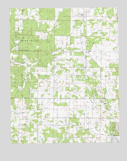
Pomona, MO USGS Topographic Map
Click on map above to begin viewing in our Map Viewer.

This topographic map contains these locations and features:
Feature Name Type Latitude Longitude GNIS ID View Map
Bridges School (historical)SchoolN36.8192°W91.9588°749022View Map
Cozy Grove HotelBuildingN36.7967°W91.8957°735100View Map
Friendship ChurchChurchN36.7909°W91.8949°753610View Map
Grimmet Church (historical)ChurchN36.7662°W91.9604°754417View Map
Grimmet School (historical)SchoolN36.7673°W91.9604°750167View Map
Henderson and Day DamDamN36.7867°W91.9635°764351View Map
Howell CountyCivilN36.7740°W91.8865°758500View Map
Lone Pine CemeteryCemeteryN36.7814°W91.9060°750831View Map
Lone Pine School (historical)SchoolN36.7720°W91.9102°750832View Map
Mount Zion ChurchChurchN36.8295°W91.9493°751204View Map
New Central School (historical)SchoolN36.7909°W91.9488°735097View Map
New Liberty CemeteryCemeteryN36.7776°W91.9871°735099View Map
New Liberty ChurchChurchN36.7776°W91.9874°753611View Map
North Fork Dry CreekStreamN36.8501°W91.9843°751337View Map
OldenPopulated PlaceN36.8339°W91.9104°751430View Map
PomonaPopulated PlaceN36.8673°W91.9143°751693View Map
Pomona Census Designated PlaceCensusN36.8670°W91.9133°2587105View Map
Pomona Fire Protection District 2BuildingN36.8724°W91.9071°2621462View Map
Pomona Post OfficePost OfficeN36.8679°W91.9164°2782903View Map
Ray's Roost AirportAirportN36.8054°W91.8807°758995View Map
Richards R-5 SchoolSchoolN36.7873°W91.8932°753609View Map
Rudville School (historical)SchoolN36.8120°W91.9043°735098View Map
Sky Haven Airport (historical)AirportN36.7639°W91.8838°753709View Map
Township of Dry CreekCivilN36.8447°W91.9184°766783View Map
West Plains Fire and Rescue Station 2BuildingN36.7568°W91.8763°2621612View Map

Note: Coordinates in the location and feature list above are referenced to NAD83 datum.


Copyright (C) 2008-2025 Ryan Niemi / Sunset Dynamics ... All Rights Reserved