TopoQuest Logo
Do you find TopoQuest useful?
Help keep TopoQuest running and adding new maps/features by donating!
Bitcoin:  19c7KJd3qBynnjoSw5npx9KScwjBe4ifkT
Litecoin:  LXs6TkuXGGXo1vDsWCkWVdjQX94eUKd6ui
Home View Maps Find Maps Find Places Resources & Links


Silver Point, Tennessee Topographic Map

USGS Map Title: Silver Point, TN
USGS Map MRC: 36085A6
DRG (GeoTIFF) Download: o36085a6.tif


Neighboring USGS Topographic Map Quads:


  Buffalo Valley, TN  
36085B7
 

  Baxter, TN  
36085B6
 

  Cookeville West, TN  
36085B5
 

  Center Hill Dam, TN  
36085A7
 

  Silver Point, TN  
36085A6
 

  Burgess Falls, TN  
36085A5
 

  Smithville, TN  
35085H7
 

  Sligo Bridge, TN  
35085H6
 

  Cassville, TN  
35085H5


Map MRC Location:

N37°
W86°
N37°
W85°
H8 H7 H6 H5 H4 H3 H2 H1
G8 G7 G6 G5 G4 G3 G2 G1
F8 F7 F6 F5 F4 F3 F2 F1
E8 E7 E6 E5 E4 E3 E2 E1
D8 D7 D6 D5 D4 D3 D2 D1
C8 C7 C6 C5 C4 C3 C2 C1
B8 B7 B6 B5 B4 B3 B2 B1
A8 A7 A6 A5 A4 A3 A2 A1
N36°
W86°
N36°
W85°

Silver Point, TN USGS 1:24K Topographic Map Preview:
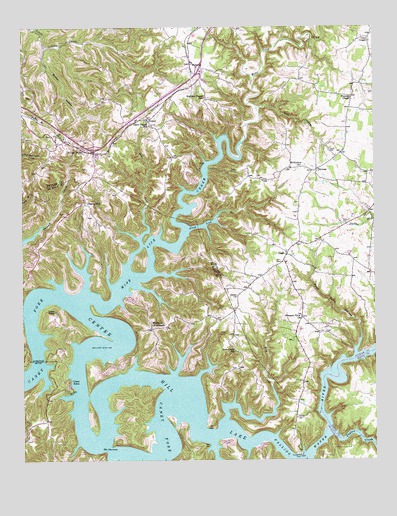
Silver Point, TN USGS Topographic Map
Click on map above to begin viewing in our Map Viewer.

This topographic map contains these locations and features:
Feature Name Type Latitude Longitude GNIS ID View Map
Alum Lick BranchStreamN36.0665°W85.6916°1313835View Map
Anderson RidgeRidgeN36.0634°W85.7255°1647636View Map
Bald Hill Church (historical)ChurchN36.0634°W85.6441°1317754View Map
Bethlehem ChurchChurchN36.0851°W85.6508°1277172View Map
BurtonPopulated PlaceN36.0626°W85.6516°1310871View Map
Burton HollowValleyN36.1194°W85.7413°1279134View Map
Burton Hollow BranchStreamN36.1195°W85.7414°1647424View Map
Burton Post Office (historical)Post OfficeN36.0623°W85.6533°1650873View Map
Burton RidgeRidgeN36.0751°W85.7144°1647637View Map
Camp RelaxLocaleN36.0220°W85.7339°1313872View Map
Camp TifhaLocaleN36.0431°W85.7383°1313873View Map
Carrs Chapel SchoolSchoolN36.0970°W85.7044°1279754View Map
Carrs Chapel United Methodist ChurchChurchN36.0962°W85.7033°1320863View Map
Cherry HillPopulated PlaceN36.0742°W85.7278°1313885View Map
Commissioner District 4CivilN36.0186°W85.7407°2464029View Map
Cookville DockLocaleN36.0012°W85.6516°1313892View Map
Davies IslandIslandN36.0137°W85.7097°1314060View Map
Dekalb County Fire Department Station 58BuildingN36.0375°W85.6755°2654945View Map
Denny CemeteryCemeteryN36.0429°W85.7240°2711609View Map
District 8 (historical)CivilN36.0501°W85.7000°1325906View Map
Dry CreekStreamN36.0117°W85.6786°1313917View Map
Dry ForkStreamN36.0537°W85.7128°1313920View Map
Ensor School (historical)SchoolN36.1087°W85.6322°1317790View Map
Falling Water RiverStreamN36.0170°W85.6922°1313768View Map
Goff CemeteryCemeteryN36.0263°W85.6741°2710721View Map
Goff RidgeRidgeN36.0284°W85.6730°1647642View Map
Harris BluffCliffN36.1187°W85.6569°1310914View Map
Herrens Chapel SchoolSchoolN36.1048°W85.6850°1287499View Map
HickeyPopulated PlaceN36.0984°W85.7055°1287542View Map
Hickey ChurchChurchN36.0981°W85.7058°1317799View Map
Hurricane BridgeBridgeN36.0290°W85.7450°1313966View Map
Interchange 273CrossingN36.0898°W85.7241°1310931View Map
Interchange 276CrossingN36.1128°W85.6869°1310930View Map
Johnson Chapel Recreation AreaParkN36.0040°W85.6680°1322576View Map
Judd CemeteryCemeteryN36.0898°W85.6405°1289866View Map
League Chapel CemeteryCemeteryN36.0103°W85.7476°2712098View Map
League Chapel School (historical)SchoolN36.0106°W85.7472°1322582View Map
Lilys ChapelChurchN36.1220°W85.6266°1291286View Map
Martin CemeteryCemeteryN36.0195°W85.7383°2712160View Map
MatthewPopulated PlaceN36.0487°W85.6716°1647431View Map
Medley RidgeRidgeN36.0812°W85.7478°1310953View Map
Mine Lick CreekStreamN36.0459°W85.7286°1314001View Map
Mose HollowValleyN36.0002°W85.6480°1314003View Map
NashPopulated PlaceN36.0598°W85.6558°1295241View Map
Nash CemeteryCemeteryN36.0689°W85.6339°1295244View Map
Nash Grove Baptist ChurchChurchN36.0570°W85.6564°1317817View Map
Nash SchoolSchoolN36.0567°W85.6575°1295246View Map
Ozion ChurchChurchN36.0473°W85.6739°1296627View Map
Pedigo CemeteryCemeteryN36.0129°W85.7482°2712327View Map
Pedigo RidgeRidgeN36.0270°W85.7369°1647650View Map
Peter Cave BranchStreamN36.0303°W85.6316°1297241View Map
Pleasant View ChurchChurchN36.0409°W85.6508°1297951View Map
Putnam County Fire Department Station 14BuildingN36.0568°W85.6579°2654895View Map
Putnam County Fire Department Station 33BuildingN36.0911°W85.7306°2654661View Map
Putnam County LandfillLocaleN36.0336°W85.6564°2677858View Map
RobertsPopulated PlaceN36.1140°W85.6900°1299611View Map
Rock CastlePopulated PlaceN36.0265°W85.6733°1314078View Map
Rock Castle Missionary Baptist Church (historical)ChurchN36.0262°W85.6744°1322616View Map
Rock Castle SchoolSchoolN36.0312°W85.6747°1314041View Map
Silver PointPopulated PlaceN36.0906°W85.7297°1303623View Map
Silver Point Baptist ChurchChurchN36.0876°W85.7250°1317836View Map
Silver Point Post OfficePost OfficeN36.0855°W85.7237°1650896View Map
Silver Point School (historical)SchoolN36.0931°W85.7350°1317837View Map
Silverpoint School (historical)SchoolN36.0909°W85.7411°1317838View Map
Taylor CreekStreamN36.0078°W85.6405°1313792View Map
The NarrowsGapN36.0037°W85.7194°1313796View Map
ThomasPopulated PlaceN36.0837°W85.6453°1314392View Map
Thomas Church (historical)ChurchN36.0809°W85.6672°1317844View Map
Thomas School (historical)SchoolN36.0851°W85.6494°1317845View Map
Thousand Pines Tree FarmLocaleN36.0825°W85.6417°2662624View Map
Tom HollowValleyN36.1016°W85.6661°1272743View Map
Tom Hollow BranchStreamN36.1020°W85.6666°1647435View Map
Vickers RidgeRidgeN36.0478°W85.6916°1647655View Map
Walker's Chapel Church CemeteryCemeteryN36.0060°W85.7488°2711162View Map
Wayside ChapelChurchN36.1045°W85.6328°1273963View Map
Whitefield RidgeRidgeN36.0628°W85.7314°1647656View Map
Williams CrossroadsPopulated PlaceN36.0378°W85.7044°1314511View Map

Note: Coordinates in the location and feature list above are referenced to NAD83 datum.


Copyright (C) 2008-2024 Ryan Niemi / Sunset Dynamics ... All Rights Reserved