TopoQuest Logo
Do you find TopoQuest useful?
Help keep TopoQuest running and adding new maps/features by donating!
Bitcoin:  19c7KJd3qBynnjoSw5npx9KScwjBe4ifkT
Litecoin:  LXs6TkuXGGXo1vDsWCkWVdjQX94eUKd6ui
Home View Maps Find Maps Find Places Resources & Links


Cassville, Tennessee Topographic Map

USGS Map Title: Cassville, TN
USGS Map MRC: 35085H5
DRG (GeoTIFF) Download: o35085h5.tif


Neighboring USGS Topographic Map Quads:


  Silver Point, TN  
36085A6
 

  Burgess Falls, TN  
36085A5
 

  Dry Valley, TN  
36085A4
 

  Sligo Bridge, TN  
35085H6
 

  Cassville, TN  
35085H5
 

  Sparta, TN  
35085H4
 

  Campaign, TN  
35085G6
 

  Doyle, TN  
35085G5
 

  Bald Knob, TN  
35085G4


Map MRC Location:

N36°
W86°
N36°
W85°
H8 H7 H6 H5 H4 H3 H2 H1
G8 G7 G6 G5 G4 G3 G2 G1
F8 F7 F6 F5 F4 F3 F2 F1
E8 E7 E6 E5 E4 E3 E2 E1
D8 D7 D6 D5 D4 D3 D2 D1
C8 C7 C6 C5 C4 C3 C2 C1
B8 B7 B6 B5 B4 B3 B2 B1
A8 A7 A6 A5 A4 A3 A2 A1
N35°
W86°
N35°
W85°

Cassville, TN USGS 1:24K Topographic Map Preview:
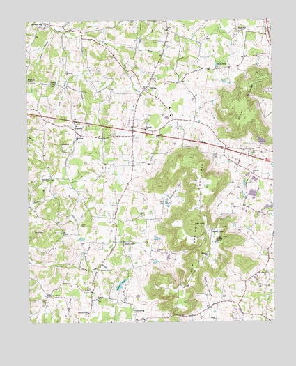
Cassville, TN USGS Topographic Map
Click on map above to begin viewing in our Map Viewer.

This topographic map contains these locations and features:
Feature Name Type Latitude Longitude GNIS ID View Map
Anderson CemeteryCemeteryN35.9037°W85.5597°1275704View Map
Arnold CemeteryCemeteryN35.9117°W85.6072°1275887View Map
Baker CemeteryCemeteryN35.9917°W85.5333°1276158View Map
Baker CemeteryCemeteryN35.9967°W85.5536°1276159View Map
Black OakPopulated PlaceN35.9953°W85.5158°1314689View Map
Black Oak CemeteryCemeteryN35.9951°W85.5161°1321168View Map
Blackwell BranchStreamN35.9326°W85.6150°1277621View Map
Boiling PondLakeN35.8905°W85.5783°1277884View Map
Cane HollowValleyN35.9961°W85.6112°1279534View Map
Carrick CoveValleyN35.9320°W85.5187°1305699View Map
Cashdollar CoveValleyN35.9248°W85.5585°1305718View Map
CassvillePopulated PlaceN35.9553°W85.6016°1279858View Map
Cassville Elementary SchoolSchoolN35.9565°W85.5997°1321173View Map
Center PointPopulated PlaceN35.8862°W85.6153°1314813View Map
Central View SchoolSchoolN35.8790°W85.5953°1280183View Map
Collins BranchStreamN35.9937°W85.5991°1280990View Map
Commissioner District 6CivilN35.9240°W85.6026°2464585View Map
Cooke CemeteryCemeteryN35.9151°W85.5980°1306080View Map
Corinth CemeteryCemeteryN35.9553°W85.5647°1321181View Map
Corinth ChurchChurchN35.9553°W85.5653°1306114View Map
Darkey Spring BranchStreamN35.8976°W85.5997°1282062View Map
Darkey SpringsPopulated PlaceN35.8967°W85.5894°1314931View Map
Davis CemeteryCemeteryN35.9417°W85.5175°1282151View Map
DibrellPopulated PlaceN35.8962°W85.5053°1312154View Map
District 3 Fire and Rescue Central ViewBuildingN35.8793°W85.5946°2654983View Map
District 5 Fire and Rescue CassvilleBuildingN35.9571°W85.5992°2654812View Map
Duck PondLakeN35.9810°W85.5281°1283047View Map
Eaton ChurchChurchN35.8759°W85.5303°1283445View Map
Eaton Institute (historical)SchoolN35.8778°W85.5166°1321191View Map
Elijah (historical)Populated PlaceN35.9590°W85.5503°1312159View Map
Fanchers MillsPopulated PlaceN35.9992°W85.6161°1315049View Map
Grace (historical)Populated PlaceN35.9759°W85.6050°1312165View Map
Gum SpringPopulated PlaceN35.8795°W85.5716°1315168View Map
Gum Spring MountainSummitN35.9151°W85.5408°1286425View Map
Hebron ChurchChurchN35.8840°W85.5900°1287311View Map
Hensley ChapelChurchN35.9081°W85.5297°1287462View Map
Hensley ChapelLocaleN35.9128°W85.5319°1287463View Map
Hensley SchoolSchoolN35.9020°W85.5341°1287474View Map
High KnobSummitN35.9151°W85.5408°1287696View Map
Hurd CemeteryCemeteryN35.8851°W85.5266°1288770View Map
Hurd HollowValleyN35.8824°W85.5297°1288771View Map
Hutchins CollegeLocaleN35.9751°W85.6244°1288864View Map
Irvin BranchStreamN35.9781°W85.5978°1289055View Map
Lake CreekStreamN35.9884°W85.5697°1290480View Map
Lansden ChurchChurchN35.9965°W85.6030°1290630View Map
Liberty CemeteryCemeteryN35.9787°W85.6050°1321198View Map
Liberty ChurchChurchN35.9784°W85.6050°1291134View Map
Mount Gilead CemeteryCemeteryN35.8953°W85.5033°1321202View Map
Mount Gilead ChurchChurchN35.8953°W85.5039°1294615View Map
Mount Gilead Volunteer Fire and RescueBuildingN35.9004°W85.5025°2654305View Map
New Hope CemeteryCemeteryN35.9478°W85.6072°1321205View Map
New Hope Missionary Baptist ChurchChurchN35.9476°W85.6075°1295543View Map
Oak Grove ChurchChurchN35.9342°W85.6139°1296101View Map
Oaklawn Memorial CemeteryCemeteryN35.9445°W85.5114°1296192View Map
Old ZionPopulated PlaceN35.9726°W85.5639°1315650View Map
Old Zion CemeteryCemeteryN35.9709°W85.5633°1321210View Map
Old Zion Cumberland Presbyterian ChurchChurchN35.9715°W85.5639°1321211View Map
Old Zion School (historical)SchoolN35.9723°W85.5630°1321212View Map
Oliveville (historical)Populated PlaceN35.9756°W85.5611°1312190View Map
Philadelphia CemeteryCemeteryN35.8842°W85.6169°1956309View Map
Plainview CemeteryCemeteryN35.9503°W85.6000°1321217View Map
Plainview ChurchChurchN35.9503°W85.6003°1297772View Map
Rum CreekStreamN35.9881°W85.5789°1300245View Map
Shady GrovePopulated PlaceN35.9081°W85.5769°1315904View Map
Shady Grove CemeteryCemeteryN35.9070°W85.5766°1321223View Map
Shady Grove Division (historical)CensusN35.9301°W85.5941°1649019View Map
Shady Grove Methodist ChurchChurchN35.9078°W85.5769°1321224View Map
Sparta Limestone QuarryMineN35.9497°W85.5061°2633420View Map
Taft ChurchChurchN35.9362°W85.5100°1272041View Map
Walker MountainSummitN35.9720°W85.5086°1273638View Map
Ward CemeteryCemeteryN35.9248°W85.5583°1304371View Map
Wesley ChapelChurchN35.9734°W85.6128°1304449View Map
Wesleys Chapel CemeteryCemeteryN35.9731°W85.6128°1321235View Map
White County LandfillLocaleN35.8942°W85.5817°2677879View Map
White Seminary (historical)SchoolN35.9162°W85.5094°1321242View Map
YatestonPopulated PlaceN35.8873°W85.5933°1314544View Map
Zion BranchStreamN35.9881°W85.5786°1275356View Map

Note: Coordinates in the location and feature list above are referenced to NAD83 datum.


Copyright (C) 2008-2024 Ryan Niemi / Sunset Dynamics ... All Rights Reserved