TopoQuest Logo
Do you find TopoQuest useful?
Help keep TopoQuest running and adding new maps/features by donating!
Bitcoin:  19c7KJd3qBynnjoSw5npx9KScwjBe4ifkT
Litecoin:  LXs6TkuXGGXo1vDsWCkWVdjQX94eUKd6ui
Home View Maps Find Maps Find Places Resources & Links


Sligo Bridge, Tennessee Topographic Map

USGS Map Title: Sligo Bridge, TN
USGS Map MRC: 35085H6
DRG (GeoTIFF) Download: o35085h6.tif


Neighboring USGS Topographic Map Quads:


  Center Hill Dam, TN  
36085A7
 

  Silver Point, TN  
36085A6
 

  Burgess Falls, TN  
36085A5
 

  Smithville, TN  
35085H7
 

  Sligo Bridge, TN  
35085H6
 

  Cassville, TN  
35085H5
 

  Dibrell, TN  
35085G7
 

  Campaign, TN  
35085G6
 

  Doyle, TN  
35085G5


Map MRC Location:

N36°
W86°
N36°
W85°
H8 H7 H6 H5 H4 H3 H2 H1
G8 G7 G6 G5 G4 G3 G2 G1
F8 F7 F6 F5 F4 F3 F2 F1
E8 E7 E6 E5 E4 E3 E2 E1
D8 D7 D6 D5 D4 D3 D2 D1
C8 C7 C6 C5 C4 C3 C2 C1
B8 B7 B6 B5 B4 B3 B2 B1
A8 A7 A6 A5 A4 A3 A2 A1
N35°
W86°
N35°
W85°

Sligo Bridge, TN USGS 1:24K Topographic Map Preview:
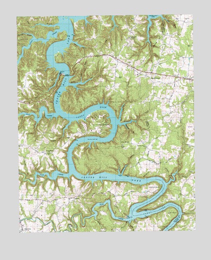
Sligo Bridge, TN USGS Topographic Map
Click on map above to begin viewing in our Map Viewer.

This topographic map contains these locations and features:
Feature Name Type Latitude Longitude GNIS ID View Map
Adcock BendBendN35.9006°W85.6497°1313826View Map
Adcock CemeteryCemeteryN35.9245°W85.6761°1313827View Map
Allen BendBendN35.8856°W85.6378°1313830View Map
Allen CemeteryCemeteryN35.8858°W85.6435°2711242View Map
Anderson CemeteryCemeteryN35.9973°W85.6672°1313836View Map
Bain BranchStreamN35.8815°W85.6708°1313841View Map
Baker CemeteryCemeteryN35.9820°W85.6289°1276157View Map
Big HollowValleyN35.9998°W85.6818°1313852View Map
Billings CemeteryCemeteryN35.9642°W85.6786°1313855View Map
Blue Spring CreekStreamN35.9390°W85.6783°1313858View Map
Britch CreekStreamN35.9606°W85.7144°1313866View Map
Caney BranchStreamN35.8837°W85.6964°1313874View Map
CatlenPopulated PlaceN35.8834°W85.7208°1307407View Map
CatlenLocaleN35.8834°W85.7222°1314056View Map
Cedar CreekStreamN35.9023°W85.6450°1280012View Map
Center Hill LakeReservoirN35.9036°W85.7400°1313767View Map
Commissioner District 5CivilN35.9441°W85.7291°2464437View Map
Cooney HollowValleyN35.8803°W85.6715°1313894View Map
Cope CemeteryCemeteryN35.9239°W85.6283°1281231View Map
Copper Cave HollowValleyN35.9389°W85.7130°1313897View Map
Dekalb County Fire Department Station 68BuildingN35.9843°W85.6724°2654937View Map
DeKalb County LandfillLocaleN35.9719°W85.6869°2677857View Map
Delong CemeteryCemeteryN35.8943°W85.6768°2711607View Map
District 14 (historical)CivilN35.9751°W85.6833°1325912View Map
District 23 (historical)CivilN35.9251°W85.6694°1325921View Map
District 25 (historical)CivilN35.9251°W85.7291°1325923View Map
District 6 (historical)CivilN35.8834°W85.7000°1325904View Map
District 7 (historical)CivilN35.8959°W85.7125°1325905View Map
Drop (historical)Populated PlaceN35.9284°W85.6516°1312157View Map
Eagle CreekStreamN35.9926°W85.7189°1313921View Map
Elkins Mill (historical)LocaleN35.8815°W85.7486°1322551View Map
Elrod CemeteryCemeteryN35.9976°W85.6353°1283730View Map
Fall CreekStreamN35.9431°W85.7222°1313928View Map
Ferguson CreekStreamN35.9373°W85.6789°1313929View Map
Four Seasons MarinaLocaleN35.9401°W85.7025°1322558View Map
George - Estes CemeteryCemeteryN35.9117°W85.7261°1852287View Map
Gleason CreekStreamN35.9084°W85.6380°1275395View Map
Hopper RidgeRidgeN35.9520°W85.6986°1647645View Map
Hutchings CemeteryCemeteryN35.9978°W85.6305°1288862View Map
Indian MoundLocaleN35.9262°W85.6778°1313972View Map
Indian Mound Baptist ChurchChurchN35.9253°W85.6761°1322572View Map
Jaco CemeteryCemeteryN35.8973°W85.7283°1313974View Map
JeffersonPopulated PlaceN35.8945°W85.7111°1315293View Map
Jefferson School (historical)SchoolN35.8951°W85.7139°1322574View Map
Johnson RidgeRidgeN35.9751°W85.7375°1647646View Map
Johnsons ChapelPopulated PlaceN35.9876°W85.6694°1314070View Map
Johnsons Chapel CemeteryCemeteryN35.9870°W85.6695°2710950View Map
Johnsons Chapel Freewill Baptist ChurchChurchN35.9867°W85.6700°1313977View Map
Jones CemeteryCemeteryN35.8833°W85.7095°2712086View Map
KeltonburgPopulated PlaceN35.8762°W85.7472°1313980View Map
Keltonburg CemeteryCemeteryN35.8762°W85.7483°2711013View Map
Keltonburg Church of ChristChurchN35.8778°W85.7483°1322578View Map
Keltonburg School (historical)SchoolN35.8753°W85.7497°1322579View Map
Keltonburg United Methodist ChurchChurchN35.8765°W85.7480°1322580View Map
Lafty HollowValleyN35.9985°W85.6559°1313982View Map
Lander CemeteryCemeteryN35.8964°W85.7419°1313983View Map
Laurel ChurchChurchN35.9770°W85.6936°1313984View Map
Laurel Hill CemeteryCemeteryN35.9769°W85.6936°2711031View Map
Long BranchStreamN35.9951°W85.7211°1313988View Map
Love CemeteryCemeteryN35.9377°W85.6933°2712110View Map
Maynard BranchStreamN35.9876°W85.7380°1313997View Map
Mount View Baptist ChurchChurchN35.9203°W85.7278°1314010View Map
New View SchoolSchoolN35.9256°W85.7497°1314018View Map
Pates Ford (historical)CrossingN35.8848°W85.6700°1314074View Map
Pates Ford DockLocaleN35.8828°W85.6733°1322609View Map
Peeled ChestnutPopulated PlaceN35.9631°W85.6558°1315691View Map
Peeled Chestnut CemeteryCemeteryN35.9639°W85.6591°1321215View Map
Peeled Chestnut Methodist ChurchChurchN35.9642°W85.6589°1321216View Map
Peeled Chestnut SchoolSchoolN35.9673°W85.6630°1314028View Map
Petty CemeteryCemeteryN35.9628°W85.7264°1314029View Map
Pin Hook Ferry (historical)CrossingN35.9059°W85.6969°1314075View Map
Pine CreekStreamN35.9092°W85.7130°1314030View Map
Pinhook (historical)Populated PlaceN35.9020°W85.6944°1314076View Map
Pollard CemeteryCemeteryN35.8995°W85.6394°1647604View Map
Quarry HollowValleyN35.9615°W85.7051°1314036View Map
Ragland Bottom Recreation AreaParkN35.9759°W85.7228°1322643View Map
Ragland HollowValleyN35.9853°W85.7111°1314038View Map
Sawmill BranchStreamN35.9081°W85.7386°1314045View Map
Shaw CemeteryCemeteryN35.9728°W85.6716°1313770View Map
Shiloh ChurchChurchN35.9642°W85.6380°1270090View Map
Short CreekStreamN35.9678°W85.7194°1313772View Map
Sink CreekStreamN35.8820°W85.6728°1313773View Map
Sligo (historical)Populated PlaceN35.9667°W85.7119°1314079View Map
Sligo BridgeBridgeN35.9659°W85.7155°1313774View Map
Sligo DockLocaleN35.9667°W85.7191°1313775View Map
Sligos Ferry (historical)CrossingN35.9659°W85.7147°1314080View Map
Steele CemeteryCemeteryN35.9800°W85.6727°2712346View Map
Stillhouse BranchStreamN35.9078°W85.6772°1313782View Map
Stillhouse HollowValleyN35.9054°W85.6602°1313783View Map
Stillhouse PointCapeN35.9078°W85.6780°1313785View Map
Taylors Providence Freewill Baptist ChurchChurchN35.9242°W85.6600°1313793View Map
Tompkins CemeteryCemeteryN35.8971°W85.6886°2712355View Map
Townsend BranchStreamN35.9370°W85.6747°1313799View Map
Vaughn CemeteryCemeteryN35.9295°W85.7133°1313808View Map
Waterfalls HollowValleyN35.9047°W85.6422°1273895View Map
Young BendPopulated PlaceN35.9209°W85.7272°1314551View Map
Young BendBendN35.9365°W85.6855°1313823View Map
Young Bend CemeteryCemeteryN35.9215°W85.7271°2711167View Map
Young CemeteryCemeteryN35.9345°W85.6943°2712372View Map

Note: Coordinates in the location and feature list above are referenced to NAD83 datum.


Copyright (C) 2008-2024 Ryan Niemi / Sunset Dynamics ... All Rights Reserved