TopoQuest Logo
Do you find TopoQuest useful?
Help keep TopoQuest running and adding new maps/features by donating!
Bitcoin:  19c7KJd3qBynnjoSw5npx9KScwjBe4ifkT
Litecoin:  LXs6TkuXGGXo1vDsWCkWVdjQX94eUKd6ui
Home View Maps Find Maps Find Places Resources & Links


Simpson South, Louisiana Topographic Map

USGS Map Title: Simpson South, LA
USGS Map MRC: 31093B1
DRG (GeoTIFF) Download: o31093b1.tif


Neighboring USGS Topographic Map Quads:


  Kurthwood, LA  
31093C2
 

  Simpson North, LA  
31093C1
 

  Temple, LA  
31092C8
 

  Slagle, LA  
31093B2
 

  Simpson South, LA  
31093B1
 

  Lacamp, LA  
31092B8
 

  Fort Polk, LA  
31093A2
 

  Birds Creek, LA  
31093A1
 

  Fullerton Lake, LA  
31092A8


Map MRC Location:

N32°
W94°
N32°
W93°
H8 H7 H6 H5 H4 H3 H2 H1
G8 G7 G6 G5 G4 G3 G2 G1
F8 F7 F6 F5 F4 F3 F2 F1
E8 E7 E6 E5 E4 E3 E2 E1
D8 D7 D6 D5 D4 D3 D2 D1
C8 C7 C6 C5 C4 C3 C2 C1
B8 B7 B6 B5 B4 B3 B2 B1
A8 A7 A6 A5 A4 A3 A2 A1
N31°
W94°
N31°
W93°

Simpson South, LA USGS 1:24K Topographic Map Preview:
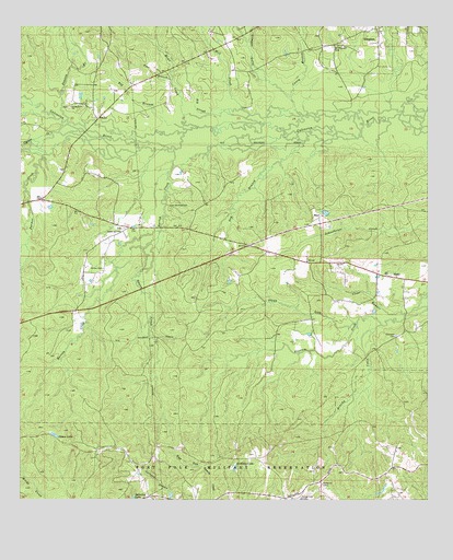
Simpson South, LA USGS Topographic Map
Click on map above to begin viewing in our Map Viewer.

This topographic map contains these locations and features:
Feature Name Type Latitude Longitude GNIS ID View Map
Armor LakeLakeN31.1423°W93.1149°553317View Map
Artillery LakeLakeN31.1339°W93.0592°553318View Map
Big BranchStreamN31.2227°W93.0740°533041View Map
Big BranchStreamN31.2160°W93.1185°533052View Map
Big SloughStreamN31.2268°W93.0552°533108View Map
Brushy CreekStreamN31.1713°W93.0146°533468View Map
Burton CreekStreamN31.2174°W93.0785°553840View Map
Caney BranchStreamN31.2266°W93.0379°547188View Map
Clear RunnerStreamN31.1743°W93.0077°533993View Map
Cowpen GullyValleyN31.2319°W93.0430°547257View Map
Cypress CreekStreamN31.2238°W93.1107°534359View Map
Dog BranchStreamN31.2196°W93.0379°534549View Map
Ebenezer CemeteryCemeteryN31.1685°W93.0099°534752View Map
Flagg LickStreamN31.1718°W93.0218°534974View Map
Flat BranchStreamN31.2357°W93.0788°534983View Map
Glass Window CemeteryCemeteryN31.2021°W93.0790°535245View Map
Hagan CreekStreamN31.1916°W93.0877°535482View Map
HicksPopulated PlaceN31.1849°W93.0160°535656View Map
Hicks Post OfficePost OfficeN31.1849°W93.0149°1631373View Map
Holton CemeteryCemeteryN31.1860°W93.0999°535749View Map
Infantry LakeLakeN31.1256°W93.0905°554831View Map
Louisiana Noname 58 DamDamN31.2002°W93.0302°556913View Map
MayoPopulated PlaceN31.1993°W93.0335°543456View Map
Mill CreekStreamN31.2260°W93.0499°547707View Map
Mims CreekStreamN31.2246°W93.0527°547723View Map
Mount Pleasant CemeteryCemeteryN31.2446°W93.0296°537387View Map
Oak Grove Church (historical)ChurchN31.2474°W93.0624°550048View Map
Parmer CreekStreamN31.2205°W93.1002°537980View Map
Prairie BranchStreamN31.2252°W93.1110°547866View Map
Range 31 TowerTowerN31.1291°W93.0327°558814View Map
Range 33D TowerTowerN31.1255°W93.0390°558815View Map
SimpsonPopulated PlaceN31.2457°W93.0154°543671View Map
Slagle Lake (historical)ReservoirN31.1924°W93.1238°550075View Map
Union Grove CemeteryCemeteryN31.2288°W93.1104°550083View Map
Union Grove ChurchChurchN31.2288°W93.1099°540101View Map
Walnut HillPopulated PlaceN31.1968°W93.0918°550086View Map
Walnut Hill ChurchChurchN31.1960°W93.0946°540224View Map

Note: Coordinates in the location and feature list above are referenced to NAD83 datum.


Copyright (C) 2008-2025 Ryan Niemi / Sunset Dynamics ... All Rights Reserved