TopoQuest Logo
Do you find TopoQuest useful?
Help keep TopoQuest running and adding new maps/features by donating!
Bitcoin:  19c7KJd3qBynnjoSw5npx9KScwjBe4ifkT
Litecoin:  LXs6TkuXGGXo1vDsWCkWVdjQX94eUKd6ui
Home View Maps Find Maps Find Places Resources & Links


Birds Creek, Louisiana Topographic Map

USGS Map Title: Birds Creek, LA
USGS Map MRC: 31093A1
DRG (GeoTIFF) Download: o31093a1.tif


Neighboring USGS Topographic Map Quads:


  Slagle, LA  
31093B2
 

  Simpson South, LA  
31093B1
 

  Lacamp, LA  
31092B8
 

  Fort Polk, LA  
31093A2
 

  Birds Creek, LA  
31093A1
 

  Fullerton Lake, LA  
31092A8
 

  Hurricane Branch, LA  
30093H2
 

  Sugrue, LA  
30093H1
 

  Pitkin, LA  
30092H8


Map MRC Location:

N32°
W94°
N32°
W93°
H8 H7 H6 H5 H4 H3 H2 H1
G8 G7 G6 G5 G4 G3 G2 G1
F8 F7 F6 F5 F4 F3 F2 F1
E8 E7 E6 E5 E4 E3 E2 E1
D8 D7 D6 D5 D4 D3 D2 D1
C8 C7 C6 C5 C4 C3 C2 C1
B8 B7 B6 B5 B4 B3 B2 B1
A8 A7 A6 A5 A4 A3 A2 A1
N31°
W94°
N31°
W93°

Birds Creek, LA USGS 1:24K Topographic Map Preview:
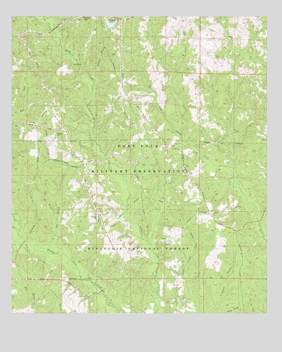
Birds Creek, LA USGS Topographic Map
Click on map above to begin viewing in our Map Viewer.

This topographic map contains these locations and features:
Feature Name Type Latitude Longitude GNIS ID View Map
Bee BranchStreamN31.0399°W93.1032°547047View Map
Big BranchStreamN31.0252°W93.0993°547072View Map
Bliss TowerLocaleN31.0660°W93.0399°547102View Map
Buckner TowerLocaleN31.0405°W93.0835°547146View Map
Calhoun BranchStreamN31.0991°W93.0865°547164View Map
Cooper TowerLocaleN31.0707°W93.0477°547246View Map
Craig TowerLocaleN31.0591°W93.0388°547259View Map
Dooley BranchStreamN31.0630°W93.1018°547303View Map
Early TowerLocaleN31.1244°W93.0463°547332View Map
Engineer LakeReservoirN31.1223°W93.0769°556877View Map
Engineer Lake DamDamN31.1219°W93.0752°556876View Map
Fort Polk Wildlife Management AreaParkN31.1169°W93.0168°550009View Map
Holly Springs CemeteryCemeteryN31.0424°W93.0293°547471View Map
Holly Springs Church (historical)ChurchN31.0421°W93.0296°550015View Map
Hunter CampLocaleN31.0082°W93.1085°548218View Map
McNair TowerLocaleN31.0555°W93.0913°547672View Map
Miles TowerLocaleN31.0977°W93.0702°547696View Map
Mill Creek CemeteryCemeteryN31.0802°W93.1132°547714View Map
OuiskeLocaleN31.0110°W93.0521°548217View Map
Roosevelt TowersLocaleN31.0755°W93.1035°547912View Map
Schofield TowerLocaleN31.0905°W93.0649°547975View Map
Smith TowerLocaleN31.0669°W93.0965°548004View Map
Stillwell TowerLocaleN31.0774°W93.1149°548040View Map
Thayer TowerLocaleN31.0769°W93.1199°548074View Map
Watson CemeteryCemeteryN31.1052°W93.0910°548126View Map
Whisky Chitto TrailTrailN31.0224°W93.0271°548205View Map

Note: Coordinates in the location and feature list above are referenced to NAD83 datum.


Copyright (C) 2008-2024 Ryan Niemi / Sunset Dynamics ... All Rights Reserved