TopoQuest Logo
Do you find TopoQuest useful?
Help keep TopoQuest running and adding new maps/features by donating!
Bitcoin:  19c7KJd3qBynnjoSw5npx9KScwjBe4ifkT
Litecoin:  LXs6TkuXGGXo1vDsWCkWVdjQX94eUKd6ui
Home View Maps Find Maps Find Places Resources & Links


Blackman, Florida Topographic Map

USGS Map Title: Blackman, FL
USGS Map MRC: 30086H6
DRG (GeoTIFF) Download: o30086h6.tif


Neighboring USGS Topographic Map Quads:


  Parker Springs, AL  
31086A7
 

  Bradley, AL  
31086A6
 

  Wing, AL  
31086A5
 

  Hurricane Lake, FL  
30086H7
 

  Blackman, FL  
30086H6
 

  Oak Grove, FL  
30086H5
 

  Munson, FL  
30086G7
 

  Baker, FL  
30086G6
 

  Crestview North, FL  
30086G5


Map MRC Location:

N31°
W87°
N31°
W86°
H8 H7 H6 H5 H4 H3 H2 H1
G8 G7 G6 G5 G4 G3 G2 G1
F8 F7 F6 F5 F4 F3 F2 F1
E8 E7 E6 E5 E4 E3 E2 E1
D8 D7 D6 D5 D4 D3 D2 D1
C8 C7 C6 C5 C4 C3 C2 C1
B8 B7 B6 B5 B4 B3 B2 B1
A8 A7 A6 A5 A4 A3 A2 A1
N30°
W87°
N30°
W86°

Blackman, FL USGS 1:24K Topographic Map Preview:
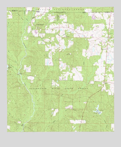
Blackman, FL USGS Topographic Map
Click on map above to begin viewing in our Map Viewer.

This topographic map contains these locations and features:
Feature Name Type Latitude Longitude GNIS ID View Map
Alligator BranchStreamN30.9821°W86.7269°159060View Map
Barrel BranchStreamN30.8952°W86.6858°305235View Map
Bee BranchStreamN30.9368°W86.7019°305264View Map
BlackmanPopulated PlaceN30.9246°W86.6366°305327View Map
Blackman Volunteer Fire DepartmentBuildingN30.9248°W86.6348°2644116View Map
Boggy Hollow CreekStreamN30.9749°W86.7288°159226View Map
Bull BranchStreamN30.9896°W86.7100°305405View Map
Bull Pen BranchStreamN30.8827°W86.7311°305408View Map
Cow Pen BranchStreamN30.9680°W86.7102°305513View Map
E C Younghood PondLakeN30.9720°W86.6574°306648View Map
Escambia FarmsPopulated PlaceN30.9580°W86.6330°305640View Map
Good HopePopulated PlaceN30.9691°W86.6313°305734View Map
Hurricane CreekStreamN30.9343°W86.7366°305848View Map
Karick LakeReservoirN30.8962°W86.6438°305895View Map
Kennedy BranchStreamN30.9438°W86.7477°305899View Map
Kennedy BridgeBridgeN30.9332°W86.7355°305900View Map
Mare CreekStreamN30.8974°W86.7175°306004View Map
Middle CreekStreamN30.9855°W86.7238°160088View Map
O G Steele PondLakeN30.9560°W86.6489°306649View Map
Oak CreekStreamN30.9577°W86.7277°306131View Map
Olive BranchStreamN30.9735°W86.6930°306154View Map
Olive Branch ChurchChurchN30.9707°W86.6805°306155View Map
Peaden BridgeBridgeN30.8821°W86.7311°306207View Map
Red Oak BridgeBridgeN30.9893°W86.7208°306271View Map
Red Oak ChurchChurchN30.9796°W86.7130°306272View Map
Rock CreekStreamN30.9388°W86.7344°160508View Map
Sand Hill Lookout TowerTowerN30.9527°W86.6761°306348View Map

Note: Coordinates in the location and feature list above are referenced to NAD83 datum.


Copyright (C) 2008-2025 Ryan Niemi / Sunset Dynamics ... All Rights Reserved