TopoQuest Logo
Do you find TopoQuest useful?
Help keep TopoQuest running and adding new maps/features by donating!
Bitcoin:  19c7KJd3qBynnjoSw5npx9KScwjBe4ifkT
Litecoin:  LXs6TkuXGGXo1vDsWCkWVdjQX94eUKd6ui
Home View Maps Find Maps Find Places Resources & Links


Spickard, Missouri Topographic Map

USGS Map Title: Spickard, MO
USGS Map MRC: 40093B5
DRG (GeoTIFF) Download: o40093b5.tif


Neighboring USGS Topographic Map Quads:


  Modena, MO  
40093C6
 

  Mill Grove, MO  
40093C5
 

  Half Rock, MO  
40093C4
 

  Brimson, MO  
40093B6
 

  Spickard, MO  
40093B5
 

  Galt, MO  
40093B4
 

  Trenton West, MO  
40093A6
 

  Trenton East, MO  
40093A5
 

  Laredo, MO  
40093A4


Map MRC Location:

N41°
W94°
N41°
W93°
H8 H7 H6 H5 H4 H3 H2 H1
G8 G7 G6 G5 G4 G3 G2 G1
F8 F7 F6 F5 F4 F3 F2 F1
E8 E7 E6 E5 E4 E3 E2 E1
D8 D7 D6 D5 D4 D3 D2 D1
C8 C7 C6 C5 C4 C3 C2 C1
B8 B7 B6 B5 B4 B3 B2 B1
A8 A7 A6 A5 A4 A3 A2 A1
N40°
W94°
N40°
W93°

Spickard, MO USGS 1:24K Topographic Map Preview:
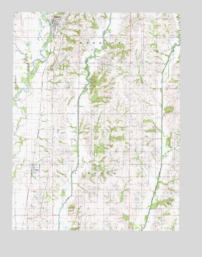
Spickard, MO USGS Topographic Map
Click on map above to begin viewing in our Map Viewer.

This topographic map contains these locations and features:
Feature Name Type Latitude Longitude GNIS ID View Map
Amick School (historical)SchoolN40.2214°W93.5808°713262View Map
Atteberry CemeteryCemeteryN40.1286°W93.5447°1782081View Map
Bethel CemeteryCemeteryN40.2381°W93.5405°714035View Map
Boswell CemeteryCemeteryN40.2325°W93.5669°1782083View Map
Brainard CemeteryCemeteryN40.1397°W93.5505°1782084View Map
Carpenter CemeteryCemeteryN40.1481°W93.5308°1782085View Map
City of SpickardCivilN40.2432°W93.5922°2395926View Map
Crockett CemeteryCemeteryN40.2000°W93.5135°1782087View Map
Denslow School (historical)SchoolN40.2217°W93.5341°716840View Map
East Honey CreekStreamN40.2345°W93.5005°717312View Map
Gehlbach School (historical)SchoolN40.1375°W93.6049°746923View Map
Herbert SchoolSchoolN40.1414°W93.5030°719393View Map
James Clark CemeteryCemeteryN40.2194°W93.5622°1782086View Map
King CemeteryCemeteryN40.2292°W93.5344°1782088View Map
Locust Grove CemeteryCemeteryN40.1403°W93.5585°1782089View Map
Locust Grove SchoolSchoolN40.1489°W93.5574°721393View Map
Martin CemeteryCemeteryN40.1964°W93.5947°721928View Map
Moore CemeteryCemeteryN40.2361°W93.6238°1782091View Map
North Evans CemeteryCemeteryN40.2353°W93.5269°723445View Map
Oak Ridge SchoolSchoolN40.1856°W93.5186°723650View Map
Owl BranchStreamN40.1645°W93.5711°723915View Map
Paint Lick ChurchChurchN40.1700°W93.5411°723961View Map
Proctor CemeteryCemeteryN40.1703°W93.5819°1782097View Map
South Evans CemeteryCemeteryN40.1736°W93.5374°1782093View Map
South Evans ChurchChurchN40.1739°W93.5369°726720View Map
Spears CemeteryCemeteryN40.2189°W93.5952°726839View Map
Speer CemeteryCemeteryN40.2186°W93.5960°1782094View Map
SpickardPopulated PlaceN40.2439°W93.5944°758449View Map
Spickard CemeteryCemeteryN40.2497°W93.5808°1782095View Map
Spickard Elementary SchoolSchoolN40.2432°W93.5941°2545252View Map
Spickard Fire Protection DistrictBuildingN40.2438°W93.5954°2621471View Map
Spickard Post OfficePost OfficeN40.2440°W93.5959°765616View Map
Steinhoff Lake DamDamN40.1450°W93.6086°760884View Map
Stepp CemeteryCemeteryN40.1653°W93.5010°1782096View Map
Terry George School (historical)SchoolN40.1845°W93.5577°746924View Map
TindallPopulated PlaceN40.1611°W93.6083°730230View Map
Tindall School (historical)SchoolN40.1603°W93.6091°746925View Map
Town of TindallCivilN40.1609°W93.6097°2397696View Map
Township of FranklinCivilN40.2356°W93.5759°766700View Map
Township of LincolnCivilN40.1629°W93.5752°766705View Map
Tracy CemeteryCemeteryN40.1894°W93.5947°1782098View Map
Veatch Lake DamDamN40.1300°W93.5536°762444View Map
West Honey CreekStreamN40.2345°W93.5005°728587View Map
West Muddy CreekStreamN40.2136°W93.6124°728600View Map
William Clark CemeteryCemeteryN40.2058°W93.5849°1782099View Map
Williams PondReservoirN40.1436°W93.6072°760885View Map
Williams SchoolSchoolN40.2464°W93.5269°728902View Map
Wise CemeteryCemeteryN40.1697°W93.5160°1782100View Map
Woods CreekStreamN40.2031°W93.6208°729124View Map
Wooley CemeteryCemeteryN40.1820°W93.5508°1782101View Map
WyandottePopulated PlaceN40.1300°W93.5452°740227View Map

Note: Coordinates in the location and feature list above are referenced to NAD83 datum.


Copyright (C) 2008-2025 Ryan Niemi / Sunset Dynamics ... All Rights Reserved