TopoQuest Logo
Do you find TopoQuest useful?
Help keep TopoQuest running and adding new maps/features by donating!
Bitcoin:  19c7KJd3qBynnjoSw5npx9KScwjBe4ifkT
Litecoin:  LXs6TkuXGGXo1vDsWCkWVdjQX94eUKd6ui
Home View Maps Find Maps Find Places Resources & Links


Trenton West, Missouri Topographic Map

USGS Map Title: Trenton West, MO
USGS Map MRC: 40093A6
DRG (GeoTIFF) Download: o40093a6.tif


Neighboring USGS Topographic Map Quads:


  Gilman City East, MO  
40093B7
 

  Brimson, MO  
40093B6
 

  Spickard, MO  
40093B5
 

  Bancroft, MO  
40093A7
 

  Trenton West, MO  
40093A6
 

  Trenton East, MO  
40093A5
 

  Jamesport, MO  
39093H7
 

  Shearwood, MO  
39093H6
 

  Farmersville, MO  
39093H5


Map MRC Location:

N41°
W94°
N41°
W93°
H8 H7 H6 H5 H4 H3 H2 H1
G8 G7 G6 G5 G4 G3 G2 G1
F8 F7 F6 F5 F4 F3 F2 F1
E8 E7 E6 E5 E4 E3 E2 E1
D8 D7 D6 D5 D4 D3 D2 D1
C8 C7 C6 C5 C4 C3 C2 C1
B8 B7 B6 B5 B4 B3 B2 B1
A8 A7 A6 A5 A4 A3 A2 A1
N40°
W94°
N40°
W93°

Trenton West, MO USGS 1:24K Topographic Map Preview:
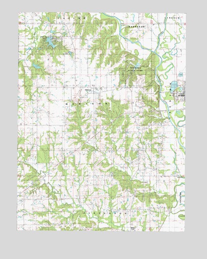
Trenton West, MO USGS Topographic Map
Click on map above to begin viewing in our Map Viewer.

This topographic map contains these locations and features:
Feature Name Type Latitude Longitude GNIS ID View Map
Big Oak SchoolSchoolN40.0828°W93.6661°714196View Map
Bill Seltzer LakeReservoirN40.0940°W93.7366°760782View Map
Bratton CemeteryCemeteryN40.0233°W93.6666°714651View Map
Coon Creek CemeteryCemeteryN40.1033°W93.7363°1782179View Map
Crowder DamDamN40.0967°W93.6602°760797View Map
Crowder LakeReservoirN40.0948°W93.6620°758373View Map
Crowder State ParkParkN40.0947°W93.6622°716550View Map
Davis Lake DamDamN40.0817°W93.6302°761371View Map
Dockery ChurchChurchN40.0117°W93.6661°716933View Map
Doctor Thompson CemeteryCemeteryN40.1169°W93.6938°1782215View Map
East Fork Wolf CreekStreamN40.0308°W93.6649°717307View Map
EdinburgPopulated PlaceN40.0814°W93.6938°730090View Map
Edinburg - Leisure Lake - Brimson Rural Volunteer Fire DepartmentBuildingN40.1111°W93.7262°2620905View Map
Edinburg Census Designated PlaceCensusN40.0811°W93.6898°2587066View Map
Edinburg Independent Order of Odd Fellows CemeteryCemeteryN40.0781°W93.6895°1782180View Map
Edinburg School (historical)SchoolN40.0833°W93.6938°746926View Map
Estes School (historical)SchoolN40.0181°W93.7094°717633View Map
Evans Peery CemeteryCemeteryN40.1011°W93.6930°1782181View Map
Fulkerson CemeteryCemeteryN40.1203°W93.7447°1782182View Map
George Peery CemeteryCemeteryN40.0808°W93.6763°724236View Map
Goodrich Lake DamDamN40.0183°W93.6669°762479View Map
Hammond Lake DamDamN40.0950°W93.7386°760781View Map
Lake WittonaReservoirN40.1015°W93.7115°758363View Map
Lake Wittona DamDamN40.1017°W93.7119°760942View Map
Leisure LakeReservoirN40.1078°W93.7263°766171View Map
Leisure Lake Census Designated PlaceCensusN40.1100°W93.7235°2587087View Map
Leisure Lake DamDamN40.1117°W93.7286°766195View Map
Leisure Lake Dam Number 2DamN40.1050°W93.7352°766197View Map
Lucas CemeteryCemeteryN40.0064°W93.7288°1782184View Map
Maple Grove CemeteryCemeteryN40.0764°W93.6322°1782185View Map
Masonic CemeteryCemeteryN40.0750°W93.6272°1782186View Map
McCammon CemeteryCemeteryN40.0667°W93.6591°1782187View Map
Metcalf CemeteryCemeteryN40.0578°W93.6702°722249View Map
Middle CreekStreamN40.1136°W93.6433°722270View Map
Mononame 574 DamDamN40.0833°W93.6336°761019View Map
Oakland School (historical)SchoolN40.0489°W93.7458°730168View Map
Peery Chapel CemeteryCemeteryN40.1111°W93.7113°1782189View Map
Peery SchoolSchoolN40.1114°W93.7147°730177View Map
Pine LakeReservoirN40.0818°W93.6292°761372View Map
Pleasant Ridge SchoolSchoolN40.0128°W93.6602°724598View Map
Raccoon ChurchChurchN40.1028°W93.7363°725042View Map
Robert Peery CemeteryCemeteryN40.0972°W93.7119°1782190View Map
Robertson School (historical)SchoolN40.0881°W93.7399°725409View Map
Roselawn CemeteryCemeteryN40.0778°W93.6333°1782191View Map
S M Rissler Elementary SchoolSchoolN40.0737°W93.6251°2545149View Map
Sandridge CemeteryCemeteryN40.0047°W93.6969°1782192View Map
Sarah Peery CemeteryCemeteryN40.0903°W93.7252°1782193View Map
Smith School (historical)SchoolN40.0461°W93.7072°726629View Map
South Oakland School (historical)SchoolN40.0145°W93.7444°726773View Map
Tate SchoolSchoolN40.0464°W93.6702°727472View Map
Township of MadisonCivilN40.0736°W93.7095°766706View Map
Trenton City ReservoirReservoirN40.0843°W93.6337°761020View Map
Trenton LakeReservoirN40.1247°W93.6886°736191View Map
Trenton Reservoir North DamDamN40.0833°W93.6369°761117View Map
Weldon RiverStreamN40.1017°W93.6486°735905View Map
West Fork Wolf CreekStreamN40.0306°W93.6652°728582View Map
Winn CemeteryCemeteryN40.0611°W93.7094°729007View Map
Wolf CreekStreamN40.0214°W93.6319°729042View Map
Zion ChurchChurchN40.0453°W93.6555°729250View Map

Note: Coordinates in the location and feature list above are referenced to NAD83 datum.


Copyright (C) 2008-2025 Ryan Niemi / Sunset Dynamics ... All Rights Reserved