TopoQuest Logo
Do you find TopoQuest useful?
Help keep TopoQuest running and adding new maps/features by donating!
Bitcoin:  19c7KJd3qBynnjoSw5npx9KScwjBe4ifkT
Litecoin:  LXs6TkuXGGXo1vDsWCkWVdjQX94eUKd6ui
Home View Maps Find Maps Find Places Resources & Links


Springdale West, Utah Topographic Map

USGS Map Title: Springdale West, UT
USGS Map MRC: 37113B1
DRG (GeoTIFF) Download: o37113b1.tif


Neighboring USGS Topographic Map Quads:


  Smith Mesa, UT  
37113C2
 

  The Guardian Angels, UT  
37113C1
 

  Temple of Sinawava, UT  
37112C8
 

  Virgin, UT  
37113B2
 

  Springdale West, UT  
37113B1
 

  Springdale East, UT  
37112B8
 

  Little Creek Mountain, UT  
37113A2
 

  Smithsonian Butte, UT  
37113A1
 

  Hildale, UT  
37112A8


Map MRC Location:

N38°
W114°
N38°
W113°
H8 H7 H6 H5 H4 H3 H2 H1
G8 G7 G6 G5 G4 G3 G2 G1
F8 F7 F6 F5 F4 F3 F2 F1
E8 E7 E6 E5 E4 E3 E2 E1
D8 D7 D6 D5 D4 D3 D2 D1
C8 C7 C6 C5 C4 C3 C2 C1
B8 B7 B6 B5 B4 B3 B2 B1
A8 A7 A6 A5 A4 A3 A2 A1
N37°
W114°
N37°
W113°

Springdale West, UT USGS 1:24K Topographic Map Preview:
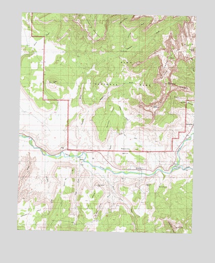
Springdale West, UT USGS Topographic Map
Click on map above to begin viewing in our Map Viewer.

This topographic map contains these locations and features:
Feature Name Type Latitude Longitude GNIS ID View Map
Altar of SacrificeSummitN37.2257°W113.0197°1438181View Map
Coalpits WashStreamN37.1689°W113.0827°1426769View Map
Cougar MountainSummitN37.2490°W113.0834°1426971View Map
Crater HillSummitN37.2104°W113.1028°1427080View Map
Eagle CragsSummitN37.1278°W113.0122°1427645View Map
East Fork Virgin RiverStreamN37.1583°W113.0147°1440823View Map
GraftonPopulated PlaceN37.1672°W113.0799°1437570View Map
Grafton CemeteryCemeteryN37.1630°W113.0808°1435603View Map
Grafton MesaSummitN37.1442°W113.0932°1428297View Map
Grafton WashStreamN37.1658°W113.1041°1428298View Map
Horse Valley WashStreamN37.1611°W113.0633°1428874View Map
Huber WashStreamN37.1619°W113.0605°1428932View Map
Jennings WashStreamN37.2300°W113.0508°1429142View Map
Meridian TowerSummitN37.2311°W113.0013°1430230View Map
Mount KinesavaSummitN37.1976°W113.0305°1429351View Map
North Fork Virgin RiverStreamN37.1622°W113.0147°1443946View Map
Obert C Tanner AmphitheaterBasinN37.2000°W113.0061°1436064View Map
Parunuweap CanyonValleyN37.1611°W113.0154°1431124View Map
Petrified ForestAreaN37.1911°W113.0605°1436115View Map
Petrified Forest TrailTrailN37.1930°W113.0527°1436116View Map
Rimrock SpringSpringN37.1508°W113.0258°1431845View Map
RockvillePopulated PlaceN37.1611°W113.0383°1431946View Map
Rockville - Springdale Fire Protection DistrictBuildingN37.1859°W113.0024°2627263View Map
Rockville BenchBenchN37.1728°W113.0424°1431947View Map
Rockville CemeteryCemeteryN37.1619°W113.0341°1436258View Map
Rockville Post OfficePost OfficeN37.1614°W113.0415°2769113View Map
Scoggins WashStreamN37.1939°W113.0763°1432277View Map
South WashStreamN37.1666°W113.0786°1432770View Map
Springdale Jolley - Gifford CemeteryCemeteryN37.1933°W113.0019°1436412View Map
Terry WashStreamN37.2389°W113.0491°1433243View Map
The SundialSummitN37.2155°W113.0242°1433435View Map
The West TempleSummitN37.2109°W113.0206°1433449View Map
Three MarysPillarN37.2083°W113.0119°1433492View Map
Towers of the VirginPillarN37.2333°W113.0174°1433611View Map
Town of RockvilleCivilN37.1478°W113.0548°2412565View Map
Town of SpringdaleCivilN37.1816°W113.0048°2413319View Map
Wire MesaSummitN37.1426°W113.0772°1434420View Map
Wire Valley KnollSummitN37.1516°W113.0694°1436659View Map
Wire Valley WashStreamN37.1536°W113.0619°1434422View Map
Zion CanyonValleyN37.1615°W113.0161°1434527View Map
Zion Community ChurchChurchN37.1616°W113.0413°1455615View Map

Note: Coordinates in the location and feature list above are referenced to NAD83 datum.


Copyright (C) 2008-2024 Ryan Niemi / Sunset Dynamics ... All Rights Reserved