TopoQuest Logo
Do you find TopoQuest useful?
Help keep TopoQuest running and adding new maps/features by donating!
Bitcoin:  19c7KJd3qBynnjoSw5npx9KScwjBe4ifkT
Litecoin:  LXs6TkuXGGXo1vDsWCkWVdjQX94eUKd6ui
Home View Maps Find Maps Find Places Resources & Links


The Guardian Angels, Utah Topographic Map

USGS Map Title: The Guardian Angels, UT
USGS Map MRC: 37113C1
DRG (GeoTIFF) Download: o37113c1.tif


Neighboring USGS Topographic Map Quads:


  Kolob Arch, UT  
37113D2
 

  Kolob Reservoir, UT  
37113D1
 

  Cogswell Point, UT  
37112D8
 

  Smith Mesa, UT  
37113C2
 

  The Guardian Angels, UT  
37113C1
 

  Temple of Sinawava, UT  
37112C8
 

  Virgin, UT  
37113B2
 

  Springdale West, UT  
37113B1
 

  Springdale East, UT  
37112B8


Map MRC Location:

N38°
W114°
N38°
W113°
H8 H7 H6 H5 H4 H3 H2 H1
G8 G7 G6 G5 G4 G3 G2 G1
F8 F7 F6 F5 F4 F3 F2 F1
E8 E7 E6 E5 E4 E3 E2 E1
D8 D7 D6 D5 D4 D3 D2 D1
C8 C7 C6 C5 C4 C3 C2 C1
B8 B7 B6 B5 B4 B3 B2 B1
A8 A7 A6 A5 A4 A3 A2 A1
N37°
W114°
N37°
W113°

The Guardian Angels, UT USGS 1:24K Topographic Map Preview:
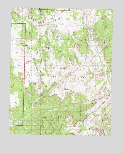
The Guardian Angels, UT USGS Topographic Map
Click on map above to begin viewing in our Map Viewer.

This topographic map contains these locations and features:
Feature Name Type Latitude Longitude GNIS ID View Map
Blue CreekStreamN37.3322°W113.0183°1425788View Map
Cave KnollSummitN37.3219°W113.1029°1426423View Map
Cave ValleyValleyN37.3001°W113.1021°1426431View Map
Double FallsFallsN37.2805°W113.0247°1435441View Map
Firepit KnollSummitN37.3497°W113.1044°1427938View Map
Grapevine SpringSpringN37.2805°W113.0958°1428342View Map
Grapevine WashStreamN37.2805°W113.0949°1450367View Map
Great West CanyonValleyN37.2701°W113.0926°1437233View Map
Greatheart MesaSummitN37.3087°W113.0249°1428386View Map
Guardian Angel PassGapN37.3069°W113.0549°1428426View Map
Inclined TempleSummitN37.2794°W113.0069°1428978View Map
Ivins MountainSummitN37.2870°W113.0057°1429068View Map
Jobs HeadSummitN37.3575°W113.0881°1429175View Map
Lambs KnollSummitN37.3048°W113.1107°1429459View Map
Lava Point TrailTrailN37.3550°W113.0405°1435849View Map
Lee ValleyValleyN37.3186°W113.0891°1429522View Map
Left Fork North CreekStreamN37.2705°W113.0924°1429541View Map
Little CreekStreamN37.2953°W113.0780°1429698View Map
Little Creek SinksBasinN37.3730°W113.0722°1429706View Map
Little Creek ValleyValleyN37.3536°W113.0710°1429708View Map
Midville SiteLocaleN37.2578°W113.1247°1435945View Map
North Guardian AngelSummitN37.3163°W113.0583°1430813View Map
Northgate PeaksSummitN37.3242°W113.0592°1430879View Map
Oak Spring ValleyValleyN37.3639°W113.0639°1430930View Map
Pine Spring WashStreamN37.2933°W113.0805°1431277View Map
Pine ValleyValleyN37.3288°W113.0693°1431279View Map
Pine Valley PeakSummitN37.3358°W113.0780°1431282View Map
Pocket MesaSummitN37.3508°W113.0689°1431349View Map
Right Fork North CreekStreamN37.2705°W113.0924°1431806View Map
Russell GulchValleyN37.3176°W113.0405°1432060View Map
Sawmill SpringsSpringN37.3686°W113.0180°1436325View Map
South Guardian AngelSummitN37.2955°W113.0598°1432719View Map
Spendlove KnollSummitN37.3371°W113.1094°1432789View Map
Tabernacle DomeSummitN37.2999°W113.0933°1433154View Map
The BishopricSummitN37.2558°W113.0158°1433272View Map
The SubwayCrossingN37.3094°W113.0505°1436443View Map
Trail CanyonValleyN37.2743°W113.0750°1433633View Map
Wildcat CanyonValleyN37.3328°W113.0181°1434267View Map
Wolf Spring WashStreamN37.3180°W113.0902°1434436View Map
Zion National ParkParkN37.2982°W113.0264°1455157View Map
Zion National Park Post Office (historical)Post OfficeN37.3000°W113.0508°2027179View Map
Zion WildernessReserveN37.3040°W113.0337°2757225View Map

Note: Coordinates in the location and feature list above are referenced to NAD83 datum.


Copyright (C) 2008-2024 Ryan Niemi / Sunset Dynamics ... All Rights Reserved