TopoQuest Logo
Do you find TopoQuest useful?
Help keep TopoQuest running and adding new maps/features by donating!
Bitcoin:  19c7KJd3qBynnjoSw5npx9KScwjBe4ifkT
Litecoin:  LXs6TkuXGGXo1vDsWCkWVdjQX94eUKd6ui
Home View Maps Find Maps Find Places Resources & Links


Spruce Pine, North Carolina Topographic Map

USGS Map Title: Spruce Pine, NC
USGS Map MRC: 35082H1
DRG (GeoTIFF) Download: o35082h1.tif


Neighboring USGS Topographic Map Quads:


  Bakersville, NC  
36082A2
 

  Carvers Gap, NC  
36082A1
 

  Newland, NC  
36081A8
 

  Micaville, NC  
35082H2
 

  Spruce Pine, NC  
35082H1
 

  Linville Falls, NC  
35081H8
 

  Celo, NC  
35082G2
 

  Little Switzerland, NC  
35082G1
 

  Ashford, NC  
35081G8


Map MRC Location:

N36°
W83°
N36°
W82°
H8 H7 H6 H5 H4 H3 H2 H1
G8 G7 G6 G5 G4 G3 G2 G1
F8 F7 F6 F5 F4 F3 F2 F1
E8 E7 E6 E5 E4 E3 E2 E1
D8 D7 D6 D5 D4 D3 D2 D1
C8 C7 C6 C5 C4 C3 C2 C1
B8 B7 B6 B5 B4 B3 B2 B1
A8 A7 A6 A5 A4 A3 A2 A1
N35°
W83°
N35°
W82°

Spruce Pine, NC USGS 1:24K Topographic Map Preview:
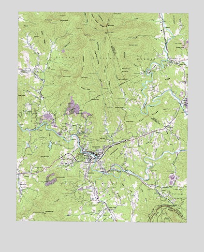
Spruce Pine, NC USGS Topographic Map
Click on map above to begin viewing in our Map Viewer.

This topographic map contains these locations and features:
Feature Name Type Latitude Longitude GNIS ID View Map
AltapassPopulated PlaceN35.8935°W82.0179°1018808View Map
Appalachian SchoolSchoolN35.9390°W82.1140°1008757View Map
Arnold KnobSummitN35.9051°W82.0157°1018853View Map
Avery - Mitchell Correctional InstitutionBuildingN35.9256°W82.0005°2769826View Map
Bailey CemeteryCemeteryN35.9248°W82.1048°1008852View Map
Bailey MeadowsFlatN35.9696°W82.0760°1008855View Map
Banjo BranchStreamN35.9082°W82.0490°1018952View Map
Beacon ChurchChurchN35.9404°W82.1168°1008972View Map
Bear CreekStreamN35.9310°W82.1090°1008994View Map
Bear Creek ChurchChurchN35.9643°W82.1104°1008999View Map
Bearpen GapGapN35.9665°W82.0487°1009034View Map
Beaver CreekStreamN35.9132°W82.0660°1009071View Map
Beaver Creek ChurchChurchN35.9296°W82.0593°1009074View Map
Beaver Creek Spruce Pine Supply DamDamN35.9632°W82.0660°1017320View Map
Bee Tree RidgeRidgeN35.9737°W82.0682°1009120View Map
Ben Cox KnobSummitN35.9935°W82.1018°1019085View Map
Bent RidgeRidgeN35.9596°W82.0198°1009193View Map
Berry ChapelChurchN35.9071°W82.0632°1009196View Map
Big BaldSummitN35.9876°W82.0593°1009249View Map
Big BranchStreamN35.9296°W82.0998°1009269View Map
Biggerstaff BranchStreamN35.9212°W82.0540°1009393View Map
Bill Davenport BranchStreamN35.9126°W82.0234°1009397View Map
Blalock CemeteryCemeteryN35.9204°W82.0551°1009467View Map
Blue Ridge Regional HospitalHospitalN35.9109°W82.0630°2701510View Map
Brad Ragan Memorial Recreation ParkParkN35.9115°W82.0698°1017881View Map
Buck RidgeRidgeN35.9373°W82.0271°1009748View Map
Burleson BaldSummitN35.9804°W82.0437°1019420View Map
Carolina Southern MineMineN35.9368°W82.1054°1010042View Map
Carter RidgeRidgeN35.8940°W82.0540°1010070View Map
Cathis CreekStreamN35.9015°W82.0496°1010107View Map
Chalk MineMineN35.9012°W82.1015°1010153View Map
Chalk MountainSummitN35.9010°W82.0968°1019599View Map
Chestnut Flats MineMineN35.9618°W82.0921°1010247View Map
Clear CreekStreamN35.9860°W82.0101°1010316View Map
Conley CemeteryCemeteryN35.9398°W82.1168°1010437View Map
Cook CemeteryCemeteryN35.9334°W82.0918°1010450View Map
Cow Mill KnobSummitN35.9946°W82.0954°1019815View Map
Cranberry BranchStreamN35.9593°W82.1051°1010558View Map
Davenport CemeteryCemeteryN35.9060°W82.0271°1010669View Map
Deaton SchoolSchoolN35.9098°W82.0885°1024819View Map
Deer Park LakeReservoirN35.9208°W82.1004°984114View Map
Deer Park Lake DamDamN35.9222°W82.0997°1017316View Map
Deer Park MineMineN35.9326°W82.1040°1010769View Map
Dogwood FlatsFlatN35.9537°W82.0576°1010867View Map
East Fork Grassy CreekStreamN35.8787°W82.0543°1010989View Map
Emerald LakeReservoirN35.8964°W82.1229°1011083View Map
English CreekStreamN35.9160°W82.0757°1011096View Map
English KnobSummitN35.9429°W82.0535°1020157View Map
EstatoePopulated PlaceN35.9035°W82.1196°1020171View Map
Fairview ChurchChurchN35.9535°W82.0259°1011142View Map
Falls of Gouges CreekFallsN35.9598°W82.0512°1011164View Map
First Freewill ChurchChurchN35.9198°W82.0451°1011223View Map
Gouges CreekStreamN35.9421°W82.0340°1011577View Map
Gouges Creek ChurchChurchN35.9487°W82.0468°1011578View Map
Grassy CreekStreamN35.9043°W82.0621°1011630View Map
Grassy CreekPopulated PlaceN35.8823°W82.0568°1020506View Map
Grassy Creek Number 1 Township (historical)CivilN35.9171°W82.0379°1026949View Map
Grassy Creek Number 2 Township (historical)CivilN35.9021°W82.0876°1026950View Map
Graveyard CreekStreamN35.8954°W82.0671°1011667View Map
Green Valley Volunteer Fire DepartmentBuildingN35.9803°W82.0159°2639553View Map
Gudger MineMineN35.9357°W82.1018°1011759View Map
Gurley CemeteryCemeteryN35.8973°W82.0143°1011780View Map
Gusher KnobSummitN35.9790°W82.0093°1020582View Map
Gusher Knob DamDamN35.9835°W82.0015°1017327View Map
Gusher Knob LakeReservoirN35.9844°W82.0016°1017326View Map
Gusher Knob MineMineN35.9807°W82.0021°1011781View Map
Hanging RockSummitN35.9354°W82.0457°1020609View Map
Hanging Rock BranchStreamN35.9254°W82.0554°1011838View Map
Harris High SchoolSchoolN35.9098°W82.0848°1011879View Map
Harris Middle SchoolSchoolN35.9129°W82.0682°1017626View Map
Harris SchoolSchoolN35.9132°W82.0676°1011882View Map
Haw CoveBayN35.9765°W82.0462°1011905View Map
Hickory FlatsFlatN35.9657°W82.0601°1012006View Map
High KnobSummitN35.9860°W82.0771°1020742View Map
Holley BranchStreamN35.9179°W82.0062°1012131View Map
Houston GapGapN35.9476°W82.0707°1012235View Map
IngallsPopulated PlaceN35.9715°W82.0118°1012354View Map
Ingram CemeteryCemeteryN35.9923°W82.0029°1012359View Map
International MineMineN35.9385°W82.0823°1012365View Map
Iowa HillSummitN35.9237°W82.0648°1012370View Map
Jakes CreekStreamN35.9132°W82.0271°1012426View Map
Jones CreekStreamN35.9818°W82.0159°1012556View Map
KalmiaPopulated PlaceN35.9298°W82.0229°1021012View Map
Ledger Fire DepartmentBuildingN35.9623°W82.1109°2639301View Map
Ledger SchoolSchoolN35.9657°W82.1148°1012793View Map
Little BaldSummitN35.9832°W82.0732°1021163View Map
Little Bear CreekStreamN35.9329°W82.1023°1012906View Map
Little Bear CreekStreamN35.9632°W82.1060°1012907View Map
Little Laurel BranchStreamN35.9162°W82.0112°1012984View Map
Little Rose CreekStreamN35.8965°W82.0232°1013021View Map
Lower BendBendN35.9429°W82.0312°1013234View Map
McHone CemeteryCemeteryN35.8976°W82.0890°1013431View Map
McKinney CemeteryCemeteryN35.8857°W82.0173°1013437View Map
McKinney GapGapN35.8848°W82.0132°1013441View Map
Middle Ridge BranchStreamN35.9182°W82.0312°1013522View Map
MinproPopulated PlaceN35.9285°W82.0868°1021492View Map
Mitchell Emergency Medical ServicesBuildingN35.9649°W82.1152°2720607View Map
Mount Carmel ChurchChurchN35.9262°W82.0398°1013733View Map
Mount Zion ChurchChurchN35.9318°W82.0148°1013790View Map
Mountain View Correctional InstitutionBuildingN35.9319°W82.0020°2769827View Map
Mullin HillSummitN35.9687°W82.0037°1021585View Map
Nettle CoveValleyN35.9775°W82.0926°1013909View Map
NormanvillePopulated PlaceN35.9632°W82.1176°1021659View Map
Parkway Fire and Rescue Station 1BuildingN35.8820°W82.0580°2639386View Map
Parkway Fire and Rescue Station 2BuildingN35.8962°W82.0230°2639394View Map
Pendley CemeteryCemeteryN35.9259°W82.0593°1014312View Map
PenlandPopulated PlaceN35.9301°W82.1121°1021863View Map
Penland Post OfficePost OfficeN35.9306°W82.1112°2766618View Map
Penland SchoolSchoolN35.9446°W82.1154°1014320View Map
Phillips CemeteryCemeteryN35.9218°W82.0726°1014366View Map
Phillips CemeteryCemeteryN35.9862°W82.0134°1014367View Map
Pine BranchStreamN35.9265°W82.0810°1014410View Map
Pine Branch ChurchChurchN35.9282°W82.0787°1014413View Map
Pine Grove ChurchChurchN35.9587°W82.0007°1014425View Map
Pine KnobSummitN35.9640°W82.0485°1021912View Map
Pine MountainSummitN35.9132°W82.1079°1021928View Map
Pizzle KnobSummitN35.9948°W82.0996°1021994View Map
Pyatt CreekStreamN35.9948°W82.0182°1014676View Map
Raven CliffsCliffN35.9923°W82.0598°1014763View Map
Road RidgeRidgeN35.9851°W82.1076°1014927View Map
Rockhouse CreekStreamN35.8751°W82.0929°1015011View Map
Roses CreekStreamN35.9007°W82.0318°1015086View Map
Rough Ridge TunnelTunnelN35.8862°W82.0187°1014887View Map
Saint Lucins ChurchChurchN35.9071°W82.0715°1015160View Map
Saylors LakeReservoirN35.9668°W82.1232°1017322View Map
Saylors Lake DamDamN35.9668°W82.1232°1017323View Map
Shafords LakeReservoirN35.8784°W82.0615°1015376View Map
Silver RunStreamN35.8893°W82.0651°1015525View Map
Silvers CemeteryCemeteryN35.9043°W82.1121°1015533View Map
Smith BranchStreamN35.8993°W82.0315°1015605View Map
Springmaid Mountain CampgroundLocaleN35.9062°W82.0073°1017882View Map
Spruce PinePopulated PlaceN35.9154°W82.0646°1015757View Map
Spruce Pine Fire and RescueBuildingN35.9151°W82.0727°2638113View Map
Spruce Pine Golf CourseLocaleN35.8929°W82.0665°1015758View Map
Spruce Pine Lookout TowerTowerN35.8798°W82.1043°1023691View Map
Spruce Pine Memorial CemeteryCemeteryN35.9037°W82.0729°1015759View Map
Spruce Pine Police DepartmentBuildingN35.9151°W82.0735°2770011View Map
Spruce Pine Post OfficePost OfficeN35.9188°W82.0607°2774168View Map
Spruce Pine ReservoirReservoirN35.9634°W82.0661°1017319View Map
Spruce Pine ReservoirReservoirN35.8913°W82.0851°1015760View Map
Spruce Pine Shopping CenterLocaleN35.9176°W82.0718°1017851View Map
Stafford CemeteryCemeteryN35.8951°W82.1207°1015775View Map
Stewart BranchStreamN35.9479°W82.1073°1015828View Map
Sullins BranchStreamN35.9262°W82.0812°1015942View Map
Swiss Pine LakeReservoirN35.8945°W82.0779°1017311View Map
Swiss Pine Lake DamDamN35.8947°W82.0765°1017312View Map
Tempa MountainSummitN35.9151°W82.0537°1022902View Map
The LookoffSummitN35.9615°W82.0787°1022922View Map
The NarrowsRidgeN35.9865°W82.0898°1016092View Map
Thomas CemeteryCemeteryN35.9476°W82.0418°1016107View Map
Threemile CreekStreamN35.9715°W82.0151°1016138View Map
Tolley CemeteryCemeteryN35.9115°W82.0823°1016171View Map
Town of Spruce PineCivilN35.9138°W82.0698°2407391View Map
Township of Grassy CreekCivilN35.8995°W82.0760°2405084View Map
Township of IngallsCivilN35.9605°W82.0020°2405088View Map
Upper BendBendN35.9662°W82.0243°1016327View Map
Vance TunnelTunnelN35.8951°W82.0246°1016362View Map
White Rock RidgeRidgeN35.9993°W82.0726°1016603View Map
White RocksSummitN35.9993°W82.0557°1023211View Map
Whiteoak CreekStreamN35.9643°W82.0304°1016613View Map
Whites Memorial ChurchChurchN35.9732°W82.0137°1016633View Map
Wiggins CoveValleyN35.9758°W82.0648°1016650View Map
Wiseman CemeteryCemeteryN35.9635°W82.0351°1016763View Map
Wolfden RidgeRidgeN35.9535°W82.0760°1016791View Map
Woodys KnobSummitN35.8798°W82.1043°1016832View Map
WTOE-AM (Spruce Pine)TowerN35.9068°W82.1057°1018512View Map
Yellow MountainSummitN35.9876°W82.0593°1023346View Map

Note: Coordinates in the location and feature list above are referenced to NAD83 datum.


Copyright (C) 2008-2025 Ryan Niemi / Sunset Dynamics ... All Rights Reserved