TopoQuest Logo
Do you find TopoQuest useful?
Help keep TopoQuest running and adding new maps/features by donating!
Bitcoin:  19c7KJd3qBynnjoSw5npx9KScwjBe4ifkT
Litecoin:  LXs6TkuXGGXo1vDsWCkWVdjQX94eUKd6ui
Home View Maps Find Maps Find Places Resources & Links


Stayton NE, Oregon Topographic Map

USGS Map Title: Stayton NE, OR
USGS Map MRC: 44122H7
DRG (GeoTIFF) Download: o44122h7.tif


Neighboring USGS Topographic Map Quads:


  Gervais, OR  
45122A8
 

  Silverton, OR  
45122A7
 

  Scotts Mills, OR  
45122A6
 

  Salem East, OR  
44122H8
 

  Stayton NE, OR  
44122H7
 

  Drake Crossing, OR  
44122H6
 

  Turner, OR  
44122G8
 

  Stayton, OR  
44122G7
 

  Stout Mountain, OR  
44122G6


Map MRC Location:

N45°
W123°
N45°
W122°
H8 H7 H6 H5 H4 H3 H2 H1
G8 G7 G6 G5 G4 G3 G2 G1
F8 F7 F6 F5 F4 F3 F2 F1
E8 E7 E6 E5 E4 E3 E2 E1
D8 D7 D6 D5 D4 D3 D2 D1
C8 C7 C6 C5 C4 C3 C2 C1
B8 B7 B6 B5 B4 B3 B2 B1
A8 A7 A6 A5 A4 A3 A2 A1
N44°
W123°
N44°
W122°

Stayton NE, OR USGS 1:24K Topographic Map Preview:
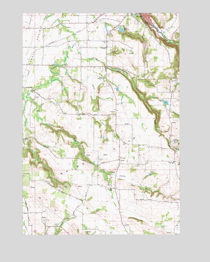
Stayton NE, OR USGS Topographic Map
Click on map above to begin viewing in our Map Viewer.

This topographic map contains these locations and features:
Feature Name Type Latitude Longitude GNIS ID View Map
Apostolic CemeteryCemeteryN44.9701°W122.8438°1162814View Map
Barnes Brothers ReservoirReservoirN44.9570°W122.8004°1130411View Map
Barnes Brothers Reservoir DamDamN44.9565°W122.8012°1163656View Map
Beaver CreekStreamN44.9710°W122.8451°1162834View Map
Beaver Creek ReservoirReservoirN44.9662°W122.8417°1163522View Map
Bye ReservoirReservoirN44.9950°W122.8503°1163570View Map
Campbell ReservoirReservoirN44.9679°W122.8004°1130409View Map
Clymer (historical)Populated PlaceN44.9012°W122.8026°1163518View Map
Clymer Post Office (historical)Post OfficeN44.9012°W122.8026°1165067View Map
Dickens CemeteryCemeteryN44.9021°W122.8409°1162941View Map
Drift CreekStreamN44.9832°W122.8348°1120086View Map
Evergreen Elementary SchoolSchoolN44.9801°W122.8101°1120544View Map
Funrue DamDamN44.9482°W122.7579°1131608View Map
Funrue ReservoirReservoirN44.9503°W122.7566°1131607View Map
Grier ReservoirReservoirN44.9420°W122.8041°1130415View Map
Howell PrairieFlatN44.9971°W122.8740°1122088View Map
Hunegs ReservoirReservoirN44.9637°W122.8118°1122858View Map
Iron Crown AirportAirportN44.9421°W122.7614°2645978View Map
Johnsons Mill (historical)LocaleN44.9837°W122.8504°1166351View Map
Kimsey - Walker CemeteryCemeteryN44.8884°W122.8606°1160993View Map
Kuenzi ReservoirReservoirN44.9637°W122.8241°1130410View Map
Lebanon Post Office (historical)Post OfficeN44.9137°W122.8165°1164465View Map
Lorence DamDamN44.9498°W122.7662°1133596View Map
Lorence ReservoirReservoirN44.9494°W122.7623°1161625View Map
McAlpin School (historical)SchoolN44.9015°W122.8054°1163130View Map
Millford (historical)LocaleN44.9846°W122.7568°1163520View Map
Mount Hope CemeteryCemeteryN44.9173°W122.8158°1163163View Map
Oregon Garden AmphitheatreLocaleN44.9978°W122.7924°2699681View Map
Pettit DamDamN44.9912°W122.8001°1133646View Map
Pettit ReservoirReservoirN44.9906°W122.7974°1163202View Map
Pratum CemeteryCemeteryN44.9526°W122.8662°1163212View Map
Quigley ReservoirReservoirN44.9271°W122.7548°1130412View Map
Rogers Wayside County ParkParkN44.9915°W122.8026°1162134View Map
S M S Dam Number 1DamN44.9082°W122.7779°1163664View Map
S M S Reservoir Number OneReservoirN44.9082°W122.7779°1163517View Map
Scandia (historical)LocaleN44.9954°W122.8170°1166352View Map
Schmid ReservoirReservoirN44.9837°W122.8112°1130407View Map
Selah (historical)LocaleN44.9873°W122.8387°1130408View Map
Silver Creek Post Office (historical)Post OfficeN44.9887°W122.7659°1164681View Map
Silverton Rural Fire Protection District Victor Point Station 2BuildingN44.9257°W122.7891°2577035View Map
South Fork Pudding RiverStreamN44.9526°W122.8720°1163519View Map
Spady ReservoirReservoirN44.9543°W122.8709°1163523View Map
Stadeli ReservoirReservoirN44.9905°W122.8091°1163521View Map
Switzerland (historical)LocaleN44.9818°W122.8554°1166747View Map
Switzerland Post Office (historical)Post OfficeN44.9818°W122.8554°1166023View Map
Urban ReservoirReservoirN44.9625°W122.8250°2791528View Map
Valley View ReservoirReservoirN44.9508°W122.7521°1130413View Map
Valley View School (historical)SchoolN44.9621°W122.7579°1128500View Map
Victor Point Elementary SchoolSchoolN44.9162°W122.7557°1128535View Map
Waldo HillsSummitN44.8955°W122.8614°1163326View Map
Waldo Hills Grange HallBuildingN44.9443°W122.8026°1639222View Map
Willard (historical)Populated PlaceN44.9429°W122.8026°1130414View Map
Willard Post Office (historical)Post OfficeN44.9429°W122.8026°1166181View Map
Wright SumpReservoirN44.9961°W122.8192°1160994View Map

Note: Coordinates in the location and feature list above are referenced to NAD83 datum.


Copyright (C) 2008-2025 Ryan Niemi / Sunset Dynamics ... All Rights Reserved