TopoQuest Logo
Do you find TopoQuest useful?
Help keep TopoQuest running and adding new maps/features by donating!
Bitcoin:  19c7KJd3qBynnjoSw5npx9KScwjBe4ifkT
Litecoin:  LXs6TkuXGGXo1vDsWCkWVdjQX94eUKd6ui
Home View Maps Find Maps Find Places Resources & Links


Steep Branch, Texas Topographic Map

USGS Map Title: Steep Branch, TX
USGS Map MRC: 30095G7
DRG (GeoTIFF) Download: o30095g7.tif


Neighboring USGS Topographic Map Quads:


  Madisonville, TX  
30095H8
 

  Connor, TX  
30095H7
 

  Baker Lake, TX  
30095H6
 

  Bedias, TX  
30095G8
 

  Steep Branch, TX  
30095G7
 

  Crabbs Prairie, TX  
30095G6
 

  Singleton, TX  
30095F8
 

  Loma, TX  
30095F7
 

  Galilee, TX  
30095F6


Map MRC Location:

N31°
W96°
N31°
W95°
H8 H7 H6 H5 H4 H3 H2 H1
G8 G7 G6 G5 G4 G3 G2 G1
F8 F7 F6 F5 F4 F3 F2 F1
E8 E7 E6 E5 E4 E3 E2 E1
D8 D7 D6 D5 D4 D3 D2 D1
C8 C7 C6 C5 C4 C3 C2 C1
B8 B7 B6 B5 B4 B3 B2 B1
A8 A7 A6 A5 A4 A3 A2 A1
N30°
W96°
N30°
W95°

Steep Branch, TX USGS 1:24K Topographic Map Preview:
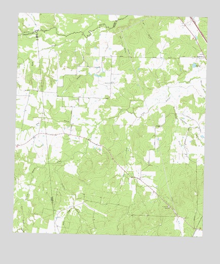
Steep Branch, TX USGS Topographic Map
Click on map above to begin viewing in our Map Viewer.

This topographic map contains these locations and features:
Feature Name Type Latitude Longitude GNIS ID View Map
Bear CreekStreamN30.8174°W95.7958°1372434View Map
Boney BranchStreamN30.8632°W95.8330°1372672View Map
Brod LakeReservoirN30.8535°W95.8452°1860102View Map
Brod Lake DamDamN30.8535°W95.8452°1860101View Map
Brushy CreekStreamN30.8619°W95.8299°1372762View Map
Cane BranchStreamN30.8677°W95.8136°1372913View Map
Carter CemeteryCemeteryN30.8457°W95.8744°1372959View Map
Haynes LakeReservoirN30.8477°W95.7584°1860104View Map
Haynes Lake DamDamN30.8469°W95.7569°1860103View Map
Jordan Ranch Airport (historical)AirportN30.7822°W95.7987°2675902View Map
Long CemeteryCemeteryN30.8063°W95.8519°1374699View Map
McAdams CemeteryCemeteryN30.7671°W95.7727°1374828View Map
Mossy GrovePopulated PlaceN30.8521°W95.7513°1380888View Map
Murff LakeReservoirN30.7701°W95.8442°1860098View Map
Murff Lake DamDamN30.7719°W95.8436°1860097View Map
Oak Grove SchoolSchoolN30.8363°W95.8133°1375242View Map
Paul ChurchChurchN30.8127°W95.7797°1375378View Map
Pine CreekStreamN30.7682°W95.8686°1375461View Map
Red Hill ChurchChurchN30.8307°W95.8661°1375672View Map
Romano LakeReservoirN30.7594°W95.8434°1860100View Map
Romano Lake DamDamN30.7619°W95.8402°1860099View Map
Salty CreekStreamN30.7655°W95.8349°1375946View Map
Sand BranchStreamN30.7527°W95.8694°1375984View Map
Schoolhouse BranchStreamN30.8182°W95.7686°1376042View Map
South Fork South Bedias CreekStreamN30.8296°W95.7730°1376210View Map
Steep BranchStreamN30.8119°W95.8227°1376295View Map
Sulphur CreekStreamN30.7913°W95.8419°1376330View Map
Ubanoski LakeReservoirN30.7556°W95.8616°1860296View Map
Ubanoski Lake DamDamN30.7569°W95.8636°1860295View Map
White Oak BranchStreamN30.8399°W95.7536°1376748View Map
Woodville ChurchChurchN30.7666°W95.7719°1376872View Map

Note: Coordinates in the location and feature list above are referenced to NAD83 datum.


Copyright (C) 2008-2024 Ryan Niemi / Sunset Dynamics ... All Rights Reserved