TopoQuest Logo
Do you find TopoQuest useful?
Help keep TopoQuest running and adding new maps/features by donating!
Bitcoin:  19c7KJd3qBynnjoSw5npx9KScwjBe4ifkT
Litecoin:  LXs6TkuXGGXo1vDsWCkWVdjQX94eUKd6ui
Home View Maps Find Maps Find Places Resources & Links


Steinaker Reservoir, Utah Topographic Map

USGS Map Title: Steinaker Reservoir, UT
USGS Map MRC: 40109E5
DRG (GeoTIFF) Download: o40109e5.tif


Neighboring USGS Topographic Map Quads:


  Taylor Mountain, UT  
40109F6
 

  Dyer Mountain, UT  
40109F5
 

  Burnt Cabin Gorge, UT  
40109F4
 

  Dry Fork, UT  
40109E6
 

  Steinaker Reservoir, UT  
40109E5
 

  Donkey Flat, UT  
40109E4
 

  Vernal NW, UT  
40109D6
 

  Vernal NE, UT  
40109D5
 

  Naples, UT  
40109D4


Map MRC Location:

N41°
W110°
N41°
W109°
H8 H7 H6 H5 H4 H3 H2 H1
G8 G7 G6 G5 G4 G3 G2 G1
F8 F7 F6 F5 F4 F3 F2 F1
E8 E7 E6 E5 E4 E3 E2 E1
D8 D7 D6 D5 D4 D3 D2 D1
C8 C7 C6 C5 C4 C3 C2 C1
B8 B7 B6 B5 B4 B3 B2 B1
A8 A7 A6 A5 A4 A3 A2 A1
N40°
W110°
N40°
W109°

Steinaker Reservoir, UT USGS 1:24K Topographic Map Preview:
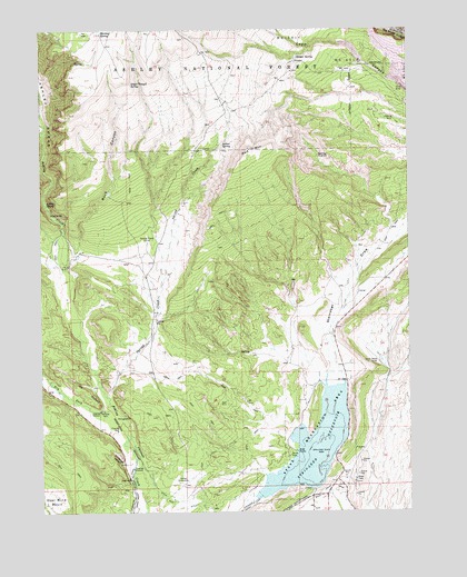
Steinaker Reservoir, UT USGS Topographic Map
Click on map above to begin viewing in our Map Viewer.

This topographic map contains these locations and features:
Feature Name Type Latitude Longitude GNIS ID View Map
Ashley Creek Recreation SiteLocaleN40.5786°W109.6229°1448089View Map
Ashley GorgeValleyN40.5852°W109.6218°1438283View Map
Ashley SpringSpringN40.5800°W109.6238°1438284View Map
Ashley SubstationLocaleN40.5083°W109.5754°1454389View Map
Dry ForkStreamN40.5261°W109.6021°1440624View Map
Enchanted CanyonValleyN40.5127°W109.5985°1440936View Map
Little Valley CorralLocaleN40.5388°W109.5104°1442801View Map
McConkie RanchLocaleN40.5250°W109.5965°1448720View Map
Merkley ParkParkN40.5269°W109.6040°1443311View Map
Merkley SpringSpringN40.6241°W109.6040°1443312View Map
Pitt DitchCanalN40.5016°W109.5782°1444463View Map
Red MountainSummitN40.5941°W109.5538°1444813View Map
Remember the Maine Picnic SiteLocaleN40.5119°W109.5960°1448908View Map
Rock CanyonValleyN40.5677°W109.6129°1445040View Map
Rock Point CanalCanalN40.5027°W109.5224°1445083View Map
Single Trough SpringSpringN40.6110°W109.5946°1445609View Map
Snider SpringSpringN40.6176°W109.5385°1445730View Map
Spring CreekStreamN40.5300°W109.6026°1446002View Map
Spring Creek CorralLocaleN40.5702°W109.5885°1446026View Map
Squaw SpringSpringN40.5952°W109.5636°1446084View Map
Steinaker CampgroundLocaleN40.5141°W109.5421°1449067View Map
Steinaker DamDamN40.5033°W109.5529°1447865View Map
Steinaker DitchCanalN40.5108°W109.5882°1446125View Map
Steinaker ReservoirReservoirN40.5160°W109.5332°1447864View Map
Steinaker State ParkParkN40.5175°W109.5304°1446129View Map

Note: Coordinates in the location and feature list above are referenced to NAD83 datum.


Copyright (C) 2008-2024 Ryan Niemi / Sunset Dynamics ... All Rights Reserved