TopoQuest Logo
Do you find TopoQuest useful?
Help keep TopoQuest running and adding new maps/features by donating!
Bitcoin:  19c7KJd3qBynnjoSw5npx9KScwjBe4ifkT
Litecoin:  LXs6TkuXGGXo1vDsWCkWVdjQX94eUKd6ui
Home View Maps Find Maps Find Places Resources & Links


Blairsville, Pennsylvania Topographic Map

USGS Map Title: Blairsville, PA
USGS Map MRC: 40079D3
DRG (GeoTIFF) Download: o40079d3.tif


Neighboring USGS Topographic Map Quads:


  Avonmore, PA  
40079E4
 

  McIntyre, PA  
40079E3
 

  Indiana, PA  
40079E2
 

  Saltsburg, PA  
40079D4
 

  Blairsville, PA  
40079D3
 

  Bolivar, PA  
40079D2
 

  Latrobe, PA  
40079C4
 

  Derry, PA  
40079C3
 

  Wilpen, PA  
40079C2


Map MRC Location:

N41°
W80°
N41°
W79°
H8 H7 H6 H5 H4 H3 H2 H1
G8 G7 G6 G5 G4 G3 G2 G1
F8 F7 F6 F5 F4 F3 F2 F1
E8 E7 E6 E5 E4 E3 E2 E1
D8 D7 D6 D5 D4 D3 D2 D1
C8 C7 C6 C5 C4 C3 C2 C1
B8 B7 B6 B5 B4 B3 B2 B1
A8 A7 A6 A5 A4 A3 A2 A1
N40°
W80°
N40°
W79°

Blairsville, PA USGS 1:24K Topographic Map Preview:
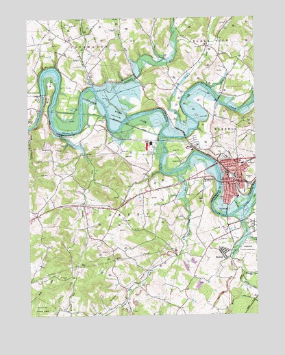
Blairsville, PA USGS Topographic Map
Click on map above to begin viewing in our Map Viewer.

This topographic map contains these locations and features:
Feature Name Type Latitude Longitude GNIS ID View Map
Aultmans RunStreamN40.4695°W79.3370°1213098View Map
BairdstownPopulated PlaceN40.4326°W79.2789°1168589View Map
Bear Cave HollowValleyN40.3823°W79.2586°1168853View Map
Blacklick CreekStreamN40.4528°W79.3011°1169762View Map
BlairsvillePopulated PlaceN40.4312°W79.2609°1169799View Map
Blairsville CemeteryCemeteryN40.4326°W79.2531°1169800View Map
Blairsville Junior High SchoolSchoolN40.4334°W79.2650°1211593View Map
Blairsville Post OfficePost OfficeN40.4304°W79.2647°2772606View Map
Blairsville Young Mens Volunteer Fire Company Station 120BuildingN40.4316°W79.2657°2644909View Map
Boatyard RunStreamN40.4531°W79.3734°1169923View Map
Borough of BlairsvilleCivilN40.4325°W79.2599°1215283View Map
BowPopulated PlaceN40.4603°W79.3595°1201624View Map
BrenizerPopulated PlaceN40.4003°W79.2681°1170197View Map
Brenizer Elementary School (historical)SchoolN40.4031°W79.2703°1214281View Map
BurrellPopulated PlaceN40.4170°W79.2661°1203195View Map
Citizens Ambulance Service Blairsville Station 20BuildingN40.4310°W79.2648°2719616View Map
Cokeville (historical)Populated PlaceN40.4184°W79.2556°1201621View Map
Conemaugh DamDamN40.4681°W79.3662°1172299View Map
Conemaugh DamDamN40.4667°W79.3664°1194836View Map
Conemaugh Lake National Recreation AreaParkN40.4684°W79.3664°1206056View Map
Conemaugh River LakeReservoirN40.4681°W79.3664°1217393View Map
DeLuca FieldParkN40.4284°W79.2548°1214314View Map
Dunlea AirparkAirportN40.4257°W79.3627°1193978View Map
FillmorePopulated PlaceN40.4634°W79.3306°1201622View Map
Greys RunStreamN40.4703°W79.2748°1176220View Map
Harbridge RunStreamN40.3923°W79.2573°1198071View Map
Hopewell ChurchChurchN40.4848°W79.2667°1177400View Map
JellisonLocaleN40.4020°W79.3323°1206825View Map
LivermorePopulated PlaceN40.4617°W79.3331°1201623View Map
McGee RunStreamN40.4165°W79.2631°1180713View Map
Miller RunStreamN40.4812°W79.3142°1192943View Map
Mount Carmel CemeteryCemeteryN40.3909°W79.3545°1181661View Map
Old Salem ChurchChurchN40.3992°W79.3281°1182935View Map
Roaring RunStreamN40.4712°W79.3392°1185182View Map
Saints Simon and Jude Catholic SchoolSchoolN40.4326°W79.2586°1211592View Map
Shirey RunStreamN40.3881°W79.2578°1187560View Map
SnyderPopulated PlaceN40.4467°W79.2848°1201620View Map
Spruce RunStreamN40.4517°W79.3573°1188343View Map
Stewart RunStreamN40.4503°W79.2942°1188651View Map
Stony RunStreamN40.4351°W79.2939°1188809View Map
Third Ward Elementary SchoolSchoolN40.4292°W79.2639°1211591View Map
Township of Black LickCivilN40.4962°W79.2561°1216533View Map
Township of DerryCivilN40.3789°W79.3170°1217235View Map

Note: Coordinates in the location and feature list above are referenced to NAD83 datum.


Copyright (C) 2008-2024 Ryan Niemi / Sunset Dynamics ... All Rights Reserved