TopoQuest Logo
Do you find TopoQuest useful?
Help keep TopoQuest running and adding new maps/features by donating!
Bitcoin:  19c7KJd3qBynnjoSw5npx9KScwjBe4ifkT
Litecoin:  LXs6TkuXGGXo1vDsWCkWVdjQX94eUKd6ui
Home View Maps Find Maps Find Places Resources & Links


Indiana, Pennsylvania Topographic Map

USGS Map Title: Indiana, PA
USGS Map MRC: 40079E2
DRG (GeoTIFF) Download: o40079e2.tif


Neighboring USGS Topographic Map Quads:


  Elderton, PA  
40079F3
 

  Ernest, PA  
40079F2
 

  Clymer, PA  
40079F1
 

  McIntyre, PA  
40079E3
 

  Indiana, PA  
40079E2
 

  Brush Valley, PA  
40079E1
 

  Blairsville, PA  
40079D3
 

  Bolivar, PA  
40079D2
 

  New Florence, PA  
40079D1


Map MRC Location:

N41°
W80°
N41°
W79°
H8 H7 H6 H5 H4 H3 H2 H1
G8 G7 G6 G5 G4 G3 G2 G1
F8 F7 F6 F5 F4 F3 F2 F1
E8 E7 E6 E5 E4 E3 E2 E1
D8 D7 D6 D5 D4 D3 D2 D1
C8 C7 C6 C5 C4 C3 C2 C1
B8 B7 B6 B5 B4 B3 B2 B1
A8 A7 A6 A5 A4 A3 A2 A1
N40°
W80°
N40°
W79°

Indiana, PA USGS 1:24K Topographic Map Preview:
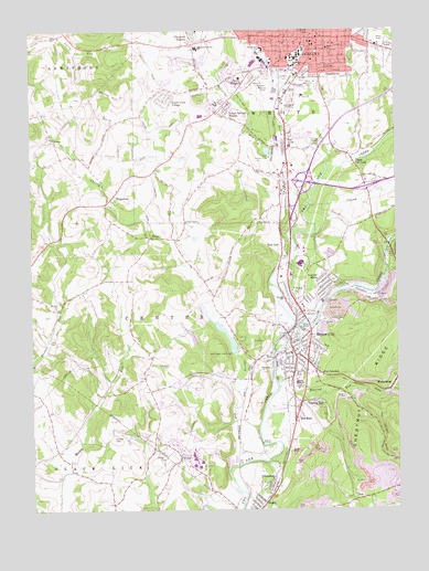
Indiana, PA USGS Topographic Map
Click on map above to begin viewing in our Map Viewer.

This topographic map contains these locations and features:
Feature Name Type Latitude Longitude GNIS ID View Map
Ben AvonPopulated PlaceN40.5948°W79.1614°1169217View Map
Benjamin Franklin Elementary SchoolSchoolN40.6203°W79.1914°1213819View Map
Bethel ChurchChurchN40.5531°W79.2417°1169390View Map
Borough of Homer CityCivilN40.5404°W79.1598°1215289View Map
Borough of IndianaCivilN40.6220°W79.1552°1215290View Map
Cherry RunStreamN40.5120°W79.1814°1171658View Map
Cherry Run DamDamN40.5417°W79.1798°1194893View Map
Cherry Run LakeReservoirN40.5469°W79.1858°1194892View Map
Citizens Ambulance Service Indiana Station HeadquartersBuildingN40.6077°W79.1563°2719614View Map
Claypoole HeightsPopulated PlaceN40.6215°W79.1928°1198274View Map
Coke Company PondReservoirN40.5134°W79.1598°1194882View Map
Coral Census Designated PlaceCensusN40.5021°W79.1745°2634210View Map
Coral Graceton Volunteer Fire Department Station 160BuildingN40.5017°W79.1711°2645502View Map
CoyPopulated PlaceN40.5292°W79.1411°1172569View Map
Coy JunctionPopulated PlaceN40.5365°W79.1525°1172570View Map
CretePopulated PlaceN40.5970°W79.2425°1203364View Map
East Pike Elementary SchoolSchoolN40.6167°W79.1250°1207205View Map
EdgewoodPopulated PlaceN40.5809°W79.2220°1174010View Map
Eisenhower Elementary SchoolSchoolN40.6203°W79.1689°1213838View Map
Getty HeightsPopulated PlaceN40.6126°W79.1767°1175574View Map
GracetonPopulated PlaceN40.5059°W79.1661°1175911View Map
Graceton Census Designated PlaceCensusN40.5071°W79.1687°2634231View Map
GrandviewPopulated PlaceN40.6140°W79.1450°1175937View Map
Homer CityPopulated PlaceN40.5434°W79.1623°1177319View Map
Homer City Police DepartmentBuildingN40.5400°W79.1596°2781054View Map
Homer City Post OfficePost OfficeN40.5426°W79.1617°2772747View Map
Homer City Volunteer Fire Department Station 180BuildingN40.5421°W79.1621°2645630View Map
Horace Mann Elementary SchoolSchoolN40.6201°W79.1470°1213877View Map
Indian Springs EstatesPopulated PlaceN40.6042°W79.1814°1177791View Map
IndianaPopulated PlaceN40.6215°W79.1525°1192667View Map
Indiana Borough Police DepartmentBuildingN40.6240°W79.1550°2781075View Map
Indiana County Fire AcademyBuildingN40.5317°W79.1466°2645546View Map
Indiana County Sheriff's OfficeBuildingN40.6234°W79.1552°2781039View Map
Indiana Fire Association CentralBuildingN40.6241°W79.1550°2645072View Map
Indiana Fire Association West - White Township Station 100BuildingN40.6090°W79.1880°2645510View Map
Indiana MallLocaleN40.6076°W79.1839°1211808View Map
Indiana Post OfficePost OfficeN40.6218°W79.1530°2772760View Map
Indiana Regional Medical CenterHospitalN40.6074°W79.1565°2718034View Map
Indiana University of PennsylvaniaSchoolN40.6176°W79.1581°1207435View Map
Kunkle CemeteryCemeteryN40.5184°W79.2220°1178709View Map
Lamar High SchoolSchoolN40.5320°W79.1581°1178814View Map
Life Flight 3 Indiana Regional Medical CenterBuildingN40.6068°W79.1561°2719557View Map
Lucerne MinesPopulated PlaceN40.5590°W79.1511°1213089View Map
Lucerne Mines Census Designated PlaceCensusN40.5560°W79.1558°2390097View Map
Lucerne Mines Post OfficePost OfficeN40.5579°W79.1513°2773192View Map
Mack Memorial ParkParkN40.6115°W79.1550°1180154View Map
Marsh RunStreamN40.6103°W79.1611°1180462View Map
McCarthy RunStreamN40.5926°W79.1645°1198092View Map
Oakland Cemetery and MausoleumCemeteryN40.6134°W79.1686°1182829View Map
Pennsylvania State Police Troop A Indiana StationBuildingN40.5900°W79.2038°2777050View Map
Red BarnPopulated PlaceN40.5245°W79.1589°1184749View Map
Regency MallLocaleN40.6165°W79.1731°1211807View Map
Risinger SchoolSchoolN40.5545°W79.1623°1185108View Map
Saint Louis ChurchChurchN40.5576°W79.1570°1186281View Map
Shado-Wood VillagePopulated PlaceN40.6092°W79.2014°1187298View Map
SmathersPopulated PlaceN40.5401°W79.2081°1201003View Map
Smathers CemeteryCemeteryN40.5382°W79.2032°1187842View Map
Special Medical Response TeamBuildingN40.5316°W79.1451°2719446View Map
Stoney RunStreamN40.5701°W79.1598°1188753View Map
Tearing RunPopulated PlaceN40.5278°W79.1536°1189334View Map
Tearing RunStreamN40.5320°W79.1653°1189335View Map
TidePopulated PlaceN40.5548°W79.1303°1189563View Map
Township of CenterCivilN40.5434°W79.1851°1216538View Map
Township of WhiteCivilN40.5933°W79.1524°1216553View Map
Two LickPopulated PlaceN40.5676°W79.1639°1190021View Map
University Elementary SchoolSchoolN40.6159°W79.1609°1214550View Map
Upper Two LickPopulated PlaceN40.5906°W79.1386°1190261View Map
Vfw Country ClubLocaleN40.5920°W79.1673°1213392View Map
Warner HillSummitN40.6078°W79.2184°1190597View Map
WatermanPopulated PlaceN40.5309°W79.1267°1190680View Map
WCQO-FM (Blairsville)TowerN40.5195°W79.2236°1200238View Map
WDAD-AM (Indiana)TowerN40.6170°W79.1317°1200438View Map
Whites RunStreamN40.6123°W79.1623°1193658View Map
Willard Orphanage Country HomeBuildingN40.6112°W79.1717°1191444View Map
WIUP-FM (Indiana)TowerN40.6159°W79.1609°1200246View Map
WQMU-FM (Indiana)TowerN40.6170°W79.1317°1200247View Map
WRID-AM (Homer City)TowerN40.5426°W79.1656°1200427View Map
Yellow CreekStreamN40.5412°W79.1664°1191873View Map

Note: Coordinates in the location and feature list above are referenced to NAD83 datum.


Copyright (C) 2008-2025 Ryan Niemi / Sunset Dynamics ... All Rights Reserved