TopoQuest Logo
Do you find TopoQuest useful?
Help keep TopoQuest running and adding new maps/features by donating!
Bitcoin:  19c7KJd3qBynnjoSw5npx9KScwjBe4ifkT
Litecoin:  LXs6TkuXGGXo1vDsWCkWVdjQX94eUKd6ui
Home View Maps Find Maps Find Places Resources & Links


Bolivar, Pennsylvania Topographic Map

USGS Map Title: Bolivar, PA
USGS Map MRC: 40079D2
DRG (GeoTIFF) Download: o40079d2.tif


Neighboring USGS Topographic Map Quads:


  McIntyre, PA  
40079E3
 

  Indiana, PA  
40079E2
 

  Brush Valley, PA  
40079E1
 

  Blairsville, PA  
40079D3
 

  Bolivar, PA  
40079D2
 

  New Florence, PA  
40079D1
 

  Derry, PA  
40079C3
 

  Wilpen, PA  
40079C2
 

  Rachelwood, PA  
40079C1


Map MRC Location:

N41°
W80°
N41°
W79°
H8 H7 H6 H5 H4 H3 H2 H1
G8 G7 G6 G5 G4 G3 G2 G1
F8 F7 F6 F5 F4 F3 F2 F1
E8 E7 E6 E5 E4 E3 E2 E1
D8 D7 D6 D5 D4 D3 D2 D1
C8 C7 C6 C5 C4 C3 C2 C1
B8 B7 B6 B5 B4 B3 B2 B1
A8 A7 A6 A5 A4 A3 A2 A1
N40°
W80°
N40°
W79°

Bolivar, PA USGS 1:24K Topographic Map Preview:
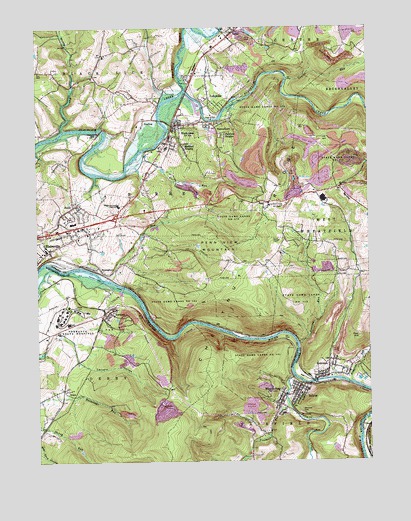
Bolivar, PA USGS Topographic Map
Click on map above to begin viewing in our Map Viewer.

This topographic map contains these locations and features:
Feature Name Type Latitude Longitude GNIS ID View Map
Bear RocksSummitN40.3817°W79.2006°1201369View Map
Black LickPopulated PlaceN40.4792°W79.1998°1169715View Map
Black Lick Census Designated PlaceCensusN40.4715°W79.1883°2389212View Map
Black Lick Post OfficePost OfficeN40.4717°W79.1976°2772604View Map
Black Lick Volunteer Fire Department Station 140BuildingN40.4724°W79.1957°2645537View Map
Blairsville IntersectionCrossingN40.4201°W79.2198°1200842View Map
Blairsville Joint High SchoolSchoolN40.4487°W79.2186°1169801View Map
BolivarPopulated PlaceN40.3970°W79.1517°1169963View Map
Bolivar Post OfficePost OfficeN40.3954°W79.1523°2773080View Map
Bolivar Volunteer Fire CompanyBuildingN40.3961°W79.1520°2645230View Map
Borough of BolivarCivilN40.3953°W79.1521°1215694View Map
Campbells MillPopulated PlaceN40.4690°W79.2292°1203215View Map
Chestnut Ridge Golf CourseLocaleN40.4409°W79.2184°1206133View Map
Conemaugh Water GapGapN40.4103°W79.1725°1201367View Map
CoralPopulated PlaceN40.4992°W79.1739°1172446View Map
Coral Post OfficePost OfficeN40.4997°W79.1736°2772648View Map
Dixon RowLocaleN40.4926°W79.2064°1200892View Map
Dixon SchoolSchoolN40.4773°W79.2181°1200890View Map
Edwards DamDamN40.4934°W79.1631°1194858View Map
Edwards PondReservoirN40.4941°W79.1617°1194857View Map
Evergreen LandfillLocaleN40.4928°W79.1369°2725988View Map
Fairfield HeightsPopulated PlaceN40.4684°W79.1792°1174431View Map
Fort HillSummitN40.4109°W79.1284°1175010View Map
Freeman RunStreamN40.3915°W79.1556°1175213View Map
Graceton DamDamN40.4984°W79.1631°1194867View Map
Gracetown ReservoirReservoirN40.4996°W79.1630°1194866View Map
GraftonPopulated PlaceN40.4734°W79.2089°1175920View Map
GraysPopulated PlaceN40.3959°W79.2398°1176028View Map
Jericho SchoolSchoolN40.4009°W79.1281°1200884View Map
JosephinePopulated PlaceN40.4773°W79.1814°1178174View Map
Laurel RunStreamN40.4851°W79.1550°1179009View Map
Mahan SchoolSchoolN40.4976°W79.2064°1200889View Map
Marshall HeightsPopulated PlaceN40.4642°W79.1931°1180467View Map
Maxwell SchoolSchoolN40.4484°W79.1681°1200886View Map
McCrea RowLocaleN40.4926°W79.2236°1200891View Map
Mount Tabor ChurchChurchN40.4537°W79.1345°1181861View Map
Muddy RunStreamN40.4706°W79.2400°1182057View Map
Old Pennsylvania CanalCanalN40.4290°W79.2325°1214227View Map
PacksaddleLocaleN40.4101°W79.1981°1200841View Map
PalmertownPopulated PlaceN40.4715°W79.1814°1183229View Map
Penn View Lookout TowerTowerN40.4484°W79.1573°1212070View Map
Penn View MountainSummitN40.4359°W79.1773°1183501View Map
Pine Ridge County ParkParkN40.4117°W79.1831°1214204View Map
Reisinger School (historical)SchoolN40.4334°W79.1764°1200885View Map
Richards RunStreamN40.3976°W79.1311°1185003View Map
Ridge SchoolSchoolN40.4542°W79.1359°1200888View Map
Roaring RunStreamN40.4092°W79.1514°1185173View Map
RobinsonPopulated PlaceN40.4042°W79.1395°1185221View Map
Robinson Census Designated PlaceCensusN40.4049°W79.1384°2630035View Map
Robinson Post OfficePost OfficeN40.3991°W79.1442°2772947View Map
SmithPopulated PlaceN40.4484°W79.2359°1187854View Map
State Game Lands Number 153ParkN40.4212°W79.1495°1188455View Map
State Game Lands Number 276ParkN40.4751°W79.1581°1208400View Map
StrangfordPopulated PlaceN40.4301°W79.2209°1188854View Map
Tannery HollowValleyN40.4040°W79.2345°1189267View Map
Toms RunStreamN40.4276°W79.2225°1189649View Map
TorrancePopulated PlaceN40.4173°W79.2228°1189666View Map
Torrance Post OfficePost OfficeN40.4167°W79.2248°2773004View Map
Torrance Post Office (historical)Post OfficeN40.4184°W79.2181°1214199View Map
Torrance State HospitalHospitalN40.4151°W79.2381°1189667View Map
Township of BurrellCivilN40.4506°W79.2083°1216536View Map
Tubmill CreekStreamN40.3992°W79.1531°1189902View Map
Two Lick CreekStreamN40.4820°W79.1928°1190022View Map
Weirs RunStreamN40.4587°W79.2153°1190787View Map
West BolivarPopulated PlaceN40.3940°W79.1564°1190883View Map
Westview CemeteryCemeteryN40.3892°W79.1503°1191182View Map

Note: Coordinates in the location and feature list above are referenced to NAD83 datum.


Copyright (C) 2008-2024 Ryan Niemi / Sunset Dynamics ... All Rights Reserved