TopoQuest Logo
Do you find TopoQuest useful?
Help keep TopoQuest running and adding new maps/features by donating!
Bitcoin:  19c7KJd3qBynnjoSw5npx9KScwjBe4ifkT
Litecoin:  LXs6TkuXGGXo1vDsWCkWVdjQX94eUKd6ui
Home View Maps Find Maps Find Places Resources & Links


Sterlington, Louisiana Topographic Map

USGS Map Title: Sterlington, LA
USGS Map MRC: 32092F1
DRG (GeoTIFF) Download: o32092f1.tif


Neighboring USGS Topographic Map Quads:


  Haile, LA  
32092G2
 

  Harrell Lake, LA  
32092G1
 

  Bastrop, LA  
32091G8
 

  Rocky Branch, LA  
32092F2
 

  Sterlington, LA  
32092F1
 

  Collinston West, LA  
32091F8
 

  West Monroe North, LA  
32092E2
 

  Monroe North, LA  
32092E1
 

  Swartz, LA  
32091E8


Map MRC Location:

N33°
W93°
N33°
W92°
H8 H7 H6 H5 H4 H3 H2 H1
G8 G7 G6 G5 G4 G3 G2 G1
F8 F7 F6 F5 F4 F3 F2 F1
E8 E7 E6 E5 E4 E3 E2 E1
D8 D7 D6 D5 D4 D3 D2 D1
C8 C7 C6 C5 C4 C3 C2 C1
B8 B7 B6 B5 B4 B3 B2 B1
A8 A7 A6 A5 A4 A3 A2 A1
N32°
W93°
N32°
W92°

Sterlington, LA USGS 1:24K Topographic Map Preview:
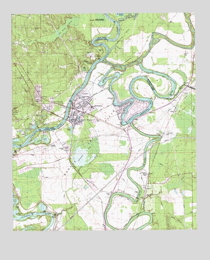
Sterlington, LA USGS Topographic Map
Click on map above to begin viewing in our Map Viewer.

This topographic map contains these locations and features:
Feature Name Type Latitude Longitude GNIS ID View Map
A L Smith Elementary SchoolSchoolN32.6963°W92.0707°556568View Map
Bakers LandingLocaleN32.6343°W92.1182°548284View Map
Bartholomew CemeteryCemeteryN32.7012°W92.0560°540821View Map
Bayou BartholomewStreamN32.7229°W92.0640°76253View Map
Black BayouStreamN32.6251°W92.0190°533167View Map
Burton CemeteryCemeteryN32.6931°W92.0322°533573View Map
Calhoun BrakeSwampN32.6903°W92.0043°533625View Map
CargasPopulated PlaceN32.6940°W92.0146°543057View Map
Cook CemeteryCemeteryN32.7360°W92.1201°554071View Map
Cypress BrakeSwampN32.6259°W92.0720°548335View Map
Davis BendBendN32.7335°W92.0696°540755View Map
De SiardPopulated PlaceN32.7082°W92.0626°543133View Map
Devils HoleLakeN32.6778°W92.1057°556567View Map
Eastern Star Church Number 1ChurchN32.6921°W92.0346°534749View Map
Elders LandingLocaleN32.6924°W92.0349°548374View Map
Evening Star Number 1 ChurchChurchN32.6918°W92.0343°540822View Map
FairbanksPopulated PlaceN32.6443°W92.0365°534876View Map
Fairbanks Baptist ChurchChurchN32.6487°W92.0343°556571View Map
Fairbanks Post OfficePost OfficeN32.6521°W92.0326°1630681View Map
First United ChurchChurchN32.7021°W92.1049°540750View Map
FowlerPopulated PlaceN32.6568°W92.0329°543219View Map
Glendora CemeteryCemeteryN32.6693°W92.1101°540747View Map
Glendora LandingLocaleN32.6843°W92.0935°548394View Map
Glendora PlantationLocaleN32.6743°W92.1004°540819View Map
Grace ChurchChurchN32.6857°W92.0446°556570View Map
GuthriePopulated PlaceN32.6812°W92.0201°543268View Map
Hamilton LandingLocaleN32.7221°W92.0654°549427View Map
HammockPopulated PlaceN32.6365°W92.0379°543272View Map
Jim Nolan BrakeSwampN32.7418°W92.0896°540752View Map
Jones BayouStreamN32.7212°W92.0707°534339View Map
KJLO-FM (Monroe)TowerN32.6601°W92.0876°1633078View Map
KlinePopulated PlaceN32.6696°W92.0882°548427View Map
KNAN-FM (Monroe)TowerN32.6601°W92.0876°1633079View Map
Lock and Dam Number FiveDamN32.7021°W92.0851°555114View Map
Lock ArborLocaleN32.6668°W92.0871°555115View Map
Lone Star ChurchChurchN32.6996°W92.1076°540749View Map
Lone Star ChurchChurchN32.6862°W92.1204°536672View Map
Lonewa BayouStreamN32.6338°W92.0982°555133View Map
Lonewa LandingLocaleN32.6335°W92.0993°548446View Map
Madison LandingLocaleN32.7035°W92.0812°548455View Map
Mill BayouStreamN32.6360°W92.0371°537091View Map
Monroe Gas FieldOilfieldN32.6482°W92.0987°544867View Map
Morehouse PointCapeN32.7232°W92.0640°546711View Map
Mount Ararat ChurchChurchN32.7126°W92.1187°537286View Map
Mount Nebo ChurchChurchN32.7265°W92.0074°537346View Map
Ouachita CityPopulated PlaceN32.7251°W92.0710°555744View Map
Ouachita Parish Fire Protection District 1 Station 9 FairbanksBuildingN32.6480°W92.0533°2673121View Map
Papaw BayouStreamN32.7446°W92.0524°559703View Map
Parish Governing Authority District CCivilN32.6296°W92.0661°1930307View Map
ParkLocaleN32.6921°W92.0896°537968View Map
Paron ChurchChurchN32.7051°W92.1082°537983View Map
PerryvillePopulated PlaceN32.7079°W92.0054°543573View Map
Persimmon BayouSwampN32.7362°W92.0496°538078View Map
PhillipsLocaleN32.6271°W92.0621°538103View Map
Phillips CemeteryCemeteryN32.6439°W92.0671°538108View Map
Pinewood CampLocaleN32.7293°W92.0668°540754View Map
Potts LandingLocaleN32.6993°W92.0565°548537View Map
Rock Row CemeteryCemeteryN32.6348°W92.1219°538660View Map
Saint Andrews Methodist ChurchChurchN32.6849°W92.0512°556569View Map
Saint James Baptist ChurchChurchN32.6879°W92.0799°548564View Map
Shiloh ChurchChurchN32.6799°W92.0251°540823View Map
Siard LandingLocaleN32.6860°W92.0432°548587View Map
Spencer CemeteryCemeteryN32.6958°W92.1246°540748View Map
Spencer West Sterlington Fire DistrictBuildingN32.7214°W92.1187°2672913View Map
SterlingtonPopulated PlaceN32.6962°W92.0860°556146View Map
Sterlington BrakeSwampN32.6699°W92.0756°540820View Map
Sterlington Church of ChristChurchN32.6962°W92.0829°548599View Map
Sterlington First Baptist ChurchChurchN32.6957°W92.0835°548600View Map
Sterlington High SchoolSchoolN32.6464°W92.0630°548601View Map
Sterlington LandingLocaleN32.6910°W92.0874°548602View Map
Sterlington Police DepartmentBuildingN32.6944°W92.0746°2755293View Map
Sterlington Post OfficePost OfficeN32.6938°W92.0743°1630706View Map
Sterlington Rehabilitation HospitalBuildingN32.6954°W92.0832°2674195View Map
Sterlington StationLocaleN32.6876°W92.0857°548603View Map
Stevens LandingLocaleN32.6982°W92.0296°548604View Map
Thompson CemeteryCemeteryN32.7274°W92.0743°540753View Map
Town of SterlingtonCivilN32.6889°W92.0603°2406666View Map
West SterlingtonPopulated PlaceN32.6990°W92.0979°540751View Map
Youngs LandingLocaleN32.6760°W92.1146°548669View Map

Note: Coordinates in the location and feature list above are referenced to NAD83 datum.


Copyright (C) 2008-2025 Ryan Niemi / Sunset Dynamics ... All Rights Reserved