TopoQuest Logo
Do you find TopoQuest useful?
Help keep TopoQuest running and adding new maps/features by donating!
Bitcoin:  19c7KJd3qBynnjoSw5npx9KScwjBe4ifkT
Litecoin:  LXs6TkuXGGXo1vDsWCkWVdjQX94eUKd6ui
Home View Maps Find Maps Find Places Resources & Links


Stitzer, Wisconsin Topographic Map

USGS Map Title: Stitzer, WI
USGS Map MRC: 42090H5
DRG (GeoTIFF) Download: o42090h5.tif


Neighboring USGS Topographic Map Quads:


  Long Hollow, WI  
43090A6
 

  Castle Rock, WI  
43090A5
 

  Highland West, WI  
43090A4
 

  Fennimore, WI  
42090H6
 

  Stitzer, WI  
42090H5
 

  Montfort, WI  
42090H4
 

  Lancaster, WI  
42090G6
 

  Ellenboro, WI  
42090G5
 

  Rewey, WI  
42090G4


Map MRC Location:

N43°
W91°
N43°
W90°
H8 H7 H6 H5 H4 H3 H2 H1
G8 G7 G6 G5 G4 G3 G2 G1
F8 F7 F6 F5 F4 F3 F2 F1
E8 E7 E6 E5 E4 E3 E2 E1
D8 D7 D6 D5 D4 D3 D2 D1
C8 C7 C6 C5 C4 C3 C2 C1
B8 B7 B6 B5 B4 B3 B2 B1
A8 A7 A6 A5 A4 A3 A2 A1
N42°
W91°
N42°
W90°

Stitzer, WI USGS 1:24K Topographic Map Preview:
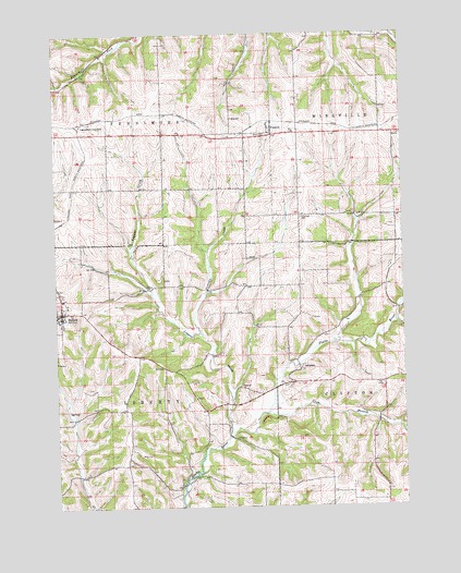
Stitzer, WI USGS Topographic Map
Click on map above to begin viewing in our Map Viewer.

This topographic map contains these locations and features:
Feature Name Type Latitude Longitude GNIS ID View Map
AnnatonPopulated PlaceN42.9114°W90.5376°1560881View Map
Blue SchoolSchoolN42.9778°W90.5610°1561957View Map
Crow BranchStreamN42.8997°W90.5496°1563566View Map
Ebenezer CemeteryCemeteryN42.9516°W90.5365°1564416View Map
Lancaster JunctionPopulated PlaceN42.9769°W90.6140°1577690View Map
Larch Grove FarmLocaleN42.9711°W90.6069°2709172View Map
Leggett CreekStreamN42.8944°W90.5632°1567946View Map
Martinville CreekStreamN42.9230°W90.5035°1577249View Map
Newell CreekStreamN42.9214°W90.5735°1570254View Map
PrestonPopulated PlaceN42.9750°W90.5471°1571923View Map
StitzerPopulated PlaceN42.9267°W90.6232°1574903View Map
Stitzer Volunteer Fire DepartmentBuildingN42.9299°W90.6228°2697688View Map
Town of FennimoreCivilN42.9887°W90.6041°1583198View Map
Town of LibertyCivilN42.9008°W90.6059°1583550View Map

Note: Coordinates in the location and feature list above are referenced to NAD83 datum.


Copyright (C) 2008-2025 Ryan Niemi / Sunset Dynamics ... All Rights Reserved