TopoQuest Logo
Do you find TopoQuest useful?
Help keep TopoQuest running and adding new maps/features by donating!
Bitcoin:  19c7KJd3qBynnjoSw5npx9KScwjBe4ifkT
Litecoin:  LXs6TkuXGGXo1vDsWCkWVdjQX94eUKd6ui
Home View Maps Find Maps Find Places Resources & Links


Stockton, Utah Topographic Map

USGS Map Title: Stockton, UT
USGS Map MRC: 40112D3
DRG (GeoTIFF) Download: o40112d3.tif


Neighboring USGS Topographic Map Quads:


  Grantsville, UT  
40112E4
 

  Tooele, UT  
40112E3
 

  Bingham Canyon, UT  
40112E2
 

  South Mountain, UT  
40112D4
 

  Stockton, UT  
40112D3
 

  Lowe Peak, UT  
40112D2
 

  Saint John, UT  
40112C4
 

  Ophir, UT  
40112C3
 

  Mercur, UT  
40112C2


Map MRC Location:

N41°
W113°
N41°
W112°
H8 H7 H6 H5 H4 H3 H2 H1
G8 G7 G6 G5 G4 G3 G2 G1
F8 F7 F6 F5 F4 F3 F2 F1
E8 E7 E6 E5 E4 E3 E2 E1
D8 D7 D6 D5 D4 D3 D2 D1
C8 C7 C6 C5 C4 C3 C2 C1
B8 B7 B6 B5 B4 B3 B2 B1
A8 A7 A6 A5 A4 A3 A2 A1
N40°
W113°
N40°
W112°

Stockton, UT USGS 1:24K Topographic Map Preview:
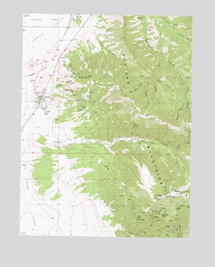
Stockton, UT USGS Topographic Map
Click on map above to begin viewing in our Map Viewer.

This topographic map contains these locations and features:
Feature Name Type Latitude Longitude GNIS ID View Map
Bald MountainSummitN40.3972°W112.2749°1425257View Map
Balsam HollowValleyN40.4519°W112.2538°1425269View Map
BauerPopulated PlaceN40.4719°W112.3622°1425327View Map
Beartrap FlatFlatN40.4661°W112.2574°1425368View Map
Ben Harrison GulchValleyN40.4733°W112.3491°1425416View Map
Ben Harrison MineMineN40.4663°W112.3291°1454661View Map
Bevans GulchValleyN40.4658°W112.2783°1425450View Map
Buckhorn SpringSpringN40.3916°W112.2613°1437297View Map
Calumet MineMineN40.4486°W112.3311°1435238View Map
Commodore PassGapN40.3980°W112.2705°1435341View Map
Edwards ForkValleyN40.4658°W112.2780°1427750View Map
Edwards PassGapN40.4436°W112.2830°1427751View Map
Hidden Treasure MineMineN40.3880°W112.2719°1435672View Map
Honerine MineMineN40.4583°W112.3411°1455325View Map
Jacob CityLocaleN40.3866°W112.2763°1437298View Map
Kelsey CanyonValleyN40.4649°W112.2574°1435815View Map
Left Hand Fork Kelsey CanyonValleyN40.4649°W112.2549°1429566View Map
Left Hand Stump ForkValleyN40.4630°W112.2838°1429574View Map
Legion Park CampgroundLocaleN40.4980°W112.2874°1435856View Map
Lynch RidgeRidgeN40.3780°W112.2599°1430024View Map
North Fork Soldier CreekStreamN40.4305°W112.2533°1436041View Map
Pipe HollowValleyN40.4294°W112.2952°1436140View Map
Queen of the Hills MineMineN40.3849°W112.2836°1436187View Map
Right Hand Dry ForkValleyN40.4649°W112.2794°1431823View Map
Right Hand ForkValleyN40.4769°W112.2719°1454321View Map
Right Hand Fork Kelsey CanyonValleyN40.4649°W112.2549°1431830View Map
Right Hand Stump ForkValleyN40.4630°W112.2838°1431836View Map
Sharp MountainSummitN40.4011°W112.2636°1432362View Map
Shoofly HillSummitN40.3980°W112.2705°1436348View Map
Silcox CanyonValleyN40.4930°W112.3274°1432447View Map
South Fork Soldier CreekStreamN40.4258°W112.2658°1432710View Map
Southport GulchValleyN40.4586°W112.3555°1432776View Map
StocktonPopulated PlaceN40.4527°W112.3608°1432990View Map
Stockton BarRidgeN40.4658°W112.3669°1450518View Map
Stockton CemeteryCemeteryN40.4591°W112.3653°1436436View Map
Stockton Police DepartmentBuildingN40.4515°W112.3599°2730508View Map
Stockton Post OfficePost OfficeN40.4559°W112.3605°2767350View Map
Stockton Volunteer Fire DepartmentBuildingN40.4549°W112.3608°2627399View Map
Tad ParkPopulated PlaceN40.4999°W112.3391°1455155View Map
The Church of Jesus Christ of Latter Day SaintsChurchN40.4572°W112.3586°1437077View Map
Tip Top MineMineN40.4583°W112.3302°1455545View Map
Tooele County Detention CenterBuildingN40.4936°W112.3332°2769026View Map
Tooele County SheriffBuildingN40.4937°W112.3325°2769025View Map
Tooele PeakSummitN40.4997°W112.2505°1437290View Map
Town of StocktonCivilN40.4496°W112.3674°2413337View Map
Water Fork Settlement CanyonValleyN40.4636°W112.2555°1454322View Map

Note: Coordinates in the location and feature list above are referenced to NAD83 datum.


Copyright (C) 2008-2024 Ryan Niemi / Sunset Dynamics ... All Rights Reserved