TopoQuest Logo
Do you find TopoQuest useful?
Help keep TopoQuest running and adding new maps/features by donating!
Bitcoin:  19c7KJd3qBynnjoSw5npx9KScwjBe4ifkT
Litecoin:  LXs6TkuXGGXo1vDsWCkWVdjQX94eUKd6ui
Home View Maps Find Maps Find Places Resources & Links


Stonewall, Virginia Topographic Map

USGS Map Title: Stonewall, VA
USGS Map MRC: 37078D8
DRG (GeoTIFF) Download: o37078d8.tif


Neighboring USGS Topographic Map Quads:


  Amherst, VA  
37079E1
 

  Buffalo Ridge, VA  
37078E8
 

  Gladstone, VA  
37078E7
 

  Kelly, VA  
37079D1
 

  Stonewall, VA  
37078D8
 

  Vera, VA  
37078D7
 

  Rustburg, VA  
37079C1
 

  Concord, VA  
37078C8
 

  Appomattox, VA  
37078C7


Map MRC Location:

N38°
W79°
N38°
W78°
H8 H7 H6 H5 H4 H3 H2 H1
G8 G7 G6 G5 G4 G3 G2 G1
F8 F7 F6 F5 F4 F3 F2 F1
E8 E7 E6 E5 E4 E3 E2 E1
D8 D7 D6 D5 D4 D3 D2 D1
C8 C7 C6 C5 C4 C3 C2 C1
B8 B7 B6 B5 B4 B3 B2 B1
A8 A7 A6 A5 A4 A3 A2 A1
N37°
W79°
N37°
W78°

Stonewall, VA USGS 1:24K Topographic Map Preview:
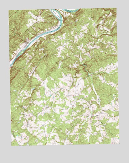
Stonewall, VA USGS Topographic Map
Click on map above to begin viewing in our Map Viewer.

This topographic map contains these locations and features:
Feature Name Type Latitude Longitude GNIS ID View Map
Abbott BranchStreamN37.4696°W78.8950°1462320View Map
BeckhamPopulated PlaceN37.4913°W78.9047°1477102View Map
Bethel ChurchChurchN37.4140°W78.9245°1463179View Map
Beulah ChurchChurchN37.4815°W78.9770°1463269View Map
Blackfoot CreekStreamN37.4401°W78.9089°1463521View Map
Buck CreekStreamN37.4024°W78.9067°1463981View Map
Fairmont Baptist ChurchChurchN37.4849°W78.9725°1466399View Map
Hebron Baptist ChurchChurchN37.4174°W78.9247°1467900View Map
Holts BranchStreamN37.3946°W78.9156°1468180View Map
Lawsons DamDamN37.3785°W78.8864°1489169View Map
Lawsons PondReservoirN37.3785°W78.8864°1489170View Map
Little Wreck Island CreekStreamN37.4526°W78.9195°1469690View Map
Mineral (historical)Populated PlaceN37.4876°W78.9067°1497265View Map
Mount Obed ChurchChurchN37.4113°W78.9603°1470957View Map
Mount Zion CemeteryCemeteryN37.4715°W78.9325°1471111View Map
Mount Zion ChurchChurchN37.4660°W78.9386°1471134View Map
North CreekStreamN37.4179°W78.8981°1471590View Map
Paradise HillSummitN37.3999°W78.9989°1499839View Map
Partridge CreekStreamN37.4688°W78.9764°1472089View Map
Pettyjohn IslandIslandN37.4949°W78.9447°1472243View Map
Rebecca CemeteryCemeteryN37.4599°W78.9283°1473037View Map
Skovhus AirportAirportN37.4138°W78.9643°1498642View Map
StapletonPopulated PlaceN37.4690°W78.9786°1477780View Map
StonewallPopulated PlaceN37.4104°W78.9603°1477783View Map
Stonewall CreekStreamN37.4729°W78.9689°1475195View Map
Stonewall MillsPopulated PlaceN37.4482°W78.9159°1500167View Map
Stonewall School (historical)SchoolN37.3826°W78.9597°1497270View Map
Trinity ChurchChurchN37.4515°W78.9422°1475867View Map
Turner MountainSummitN37.4535°W78.9903°1475985View Map
Walkers Ford CreekStreamN37.4993°W78.9328°1476247View Map
Wreck Island DistrictCivilN37.4028°W78.9335°2391231View Map

Note: Coordinates in the location and feature list above are referenced to NAD83 datum.


Copyright (C) 2008-2025 Ryan Niemi / Sunset Dynamics ... All Rights Reserved