TopoQuest Logo
Do you find TopoQuest useful?
Help keep TopoQuest running and adding new maps/features by donating!
Bitcoin:  19c7KJd3qBynnjoSw5npx9KScwjBe4ifkT
Litecoin:  LXs6TkuXGGXo1vDsWCkWVdjQX94eUKd6ui
Home View Maps Find Maps Find Places Resources & Links


Buffalo Ridge, Virginia Topographic Map

USGS Map Title: Buffalo Ridge, VA
USGS Map MRC: 37078E8
DRG (GeoTIFF) Download: o37078e8.tif


Neighboring USGS Topographic Map Quads:


  Piney River, VA  
37079F1
 

  Arrington, VA  
37078F8
 

  Shipman, VA  
37078F7
 

  Amherst, VA  
37079E1
 

  Buffalo Ridge, VA  
37078E8
 

  Gladstone, VA  
37078E7
 

  Kelly, VA  
37079D1
 

  Stonewall, VA  
37078D8
 

  Vera, VA  
37078D7


Map MRC Location:

N38°
W79°
N38°
W78°
H8 H7 H6 H5 H4 H3 H2 H1
G8 G7 G6 G5 G4 G3 G2 G1
F8 F7 F6 F5 F4 F3 F2 F1
E8 E7 E6 E5 E4 E3 E2 E1
D8 D7 D6 D5 D4 D3 D2 D1
C8 C7 C6 C5 C4 C3 C2 C1
B8 B7 B6 B5 B4 B3 B2 B1
A8 A7 A6 A5 A4 A3 A2 A1
N37°
W79°
N37°
W78°

Buffalo Ridge, VA USGS 1:24K Topographic Map Preview:
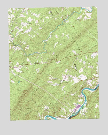
Buffalo Ridge, VA USGS Topographic Map
Click on map above to begin viewing in our Map Viewer.

This topographic map contains these locations and features:
Feature Name Type Latitude Longitude GNIS ID View Map
Amherst WaysideParkN37.5643°W78.9603°1462447View Map
Buffalo RidgeRidgeN37.5813°W78.9153°1464049View Map
Buffalo RiverStreamN37.6226°W78.8970°1482153View Map
Christian IslandIslandN37.5054°W78.9103°1464891View Map
Christian Mill CreekStreamN37.5004°W78.9503°1464892View Map
District 1CivilN37.5384°W78.9956°1927177View Map
Dry BranchStreamN37.5440°W78.8984°1465972View Map
Dyestone RidgeRidgeN37.5321°W78.9128°1466075View Map
Galilee Baptist ChurchChurchN37.5438°W78.9253°1466955View Map
Gladstone Post OfficePost OfficeN37.5719°W78.8961°2766366View Map
Larkin MountainSummitN37.5363°W78.9522°1493178View Map
Middle Branch Rocky CreekStreamN37.5468°W78.9975°1474249View Map
PiedmontPopulated PlaceN37.6110°W78.9217°1477623View Map
Poplar ChurchChurchN37.5599°W78.9967°1472639View Map
RivervillePopulated PlaceN37.5251°W78.8967°1493496View Map
Rocky CreekStreamN37.5729°W78.9767°1473452View Map
Saint James ChurchChurchN37.5282°W78.9103°1473735View Map
Shrader LakeReservoirN37.5427°W78.9867°1474569View Map
Taylors CreekStreamN37.6124°W78.9167°1475516View Map
Turner CreekStreamN37.5976°W78.9981°1488039View Map
Walkers FordPopulated PlaceN37.5026°W78.9356°1477852View Map
Wesleyan ChurchChurchN37.6074°W78.9711°1476467View Map
Wreck IslandIslandN37.5146°W78.8961°1476998View Map
Wreck Island CreekStreamN37.5110°W78.8984°1477000View Map

Note: Coordinates in the location and feature list above are referenced to NAD83 datum.


Copyright (C) 2008-2025 Ryan Niemi / Sunset Dynamics ... All Rights Reserved