TopoQuest Logo
Do you find TopoQuest useful?
Help keep TopoQuest running and adding new maps/features by donating!
Bitcoin:  19c7KJd3qBynnjoSw5npx9KScwjBe4ifkT
Litecoin:  LXs6TkuXGGXo1vDsWCkWVdjQX94eUKd6ui
Home View Maps Find Maps Find Places Resources & Links


Storden, Minnesota Topographic Map

USGS Map Title: Storden, MN
USGS Map MRC: 44095A3
DRG (GeoTIFF) Download: o44095a3.tif


Neighboring USGS Topographic Map Quads:


  Walnut Grove, MN  
44095B4
 

  Lamberton, MN  
44095B3
 

  Sanborn, MN  
44095B2
 

  Westbrook, MN  
44095A4
 

  Storden, MN  
44095A3
 

  Jeffers, MN  
44095A2
 

  Heron Lake NW, MN  
43095H4
 

  Heron Lake NE, MN  
43095H3
 

  Harder Lake, MN  
43095H2


Map MRC Location:

N45°
W96°
N45°
W95°
H8 H7 H6 H5 H4 H3 H2 H1
G8 G7 G6 G5 G4 G3 G2 G1
F8 F7 F6 F5 F4 F3 F2 F1
E8 E7 E6 E5 E4 E3 E2 E1
D8 D7 D6 D5 D4 D3 D2 D1
C8 C7 C6 C5 C4 C3 C2 C1
B8 B7 B6 B5 B4 B3 B2 B1
A8 A7 A6 A5 A4 A3 A2 A1
N44°
W96°
N44°
W95°

Storden, MN USGS 1:24K Topographic Map Preview:
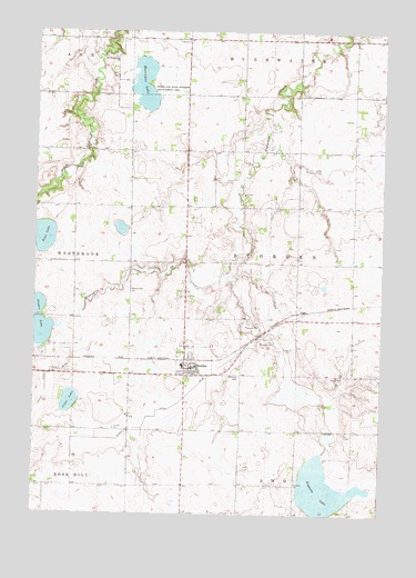
Storden, MN USGS Topographic Map
Click on map above to begin viewing in our Map Viewer.

This topographic map contains these locations and features:
Feature Name Type Latitude Longitude GNIS ID View Map
Augusta LakeLakeN44.0065°W95.2708°639518View Map
Bean LakeLakeN44.0715°W95.3735°639751View Map
Bethany CemeteryCemeteryN44.0355°W95.3011°639994View Map
Bethany Lutheran ChurchChurchN44.0380°W95.3169°2051077View Map
City of StordenCivilN44.0396°W95.3193°2395975View Map
Clear LakeLakeN44.0288°W95.3625°641275View Map
County Ditch Number FortytwoCanalN44.0325°W95.3708°642088View Map
County Ditch Number ThirtysevenCanalN44.0280°W95.3239°642025View Map
Double LakeLakeN44.0469°W95.3725°642901View Map
Highwater ParkParkN44.1244°W95.2622°2051023View Map
Hurricane LakeLakeN44.1081°W95.3364°645310View Map
Hurricane State Wildlife Management AreaParkN44.1113°W95.3369°645311View Map
Old Westbrook CemeteryCemeteryN44.1184°W95.3505°2050997View Map
Old Westbrook ChurchChurchN44.1183°W95.3483°648937View Map
Sara ParkParkN44.0052°W95.2567°2051022View Map
StordenPopulated PlaceN44.0377°W95.3183°652733View Map
Storden (historical)LocaleN44.0400°W95.3206°2051079View Map
Storden Baptist CemeteryCemeteryN44.0580°W95.3417°652699View Map
Storden Baptist ChurchChurchN44.0419°W95.3214°2051078View Map
Storden Post OfficePost OfficeN44.0381°W95.3191°2051080View Map
Storden Volunteer Fire DepartmentBuildingN44.0400°W95.3186°2666670View Map
Township of StordenCivilN44.0652°W95.2805°665723View Map

Note: Coordinates in the location and feature list above are referenced to NAD83 datum.


Copyright (C) 2008-2025 Ryan Niemi / Sunset Dynamics ... All Rights Reserved