TopoQuest Logo
Do you find TopoQuest useful?
Help keep TopoQuest running and adding new maps/features by donating!
Bitcoin:  19c7KJd3qBynnjoSw5npx9KScwjBe4ifkT
Litecoin:  LXs6TkuXGGXo1vDsWCkWVdjQX94eUKd6ui
Home View Maps Find Maps Find Places Resources & Links


Keysville, Georgia Topographic Map

USGS Map Title: Keysville, GA
USGS Map MRC: 33082B2
DRG (GeoTIFF) Download: o33082b2.tif


Neighboring USGS Topographic Map Quads:


  Avondale, GA  
33082C3
 

  Blythe, GA  
33082C2
 

  Hephzibah, GA  
33082C1
 

  Matthews, GA  
33082B3
 

  Keysville, GA  
33082B2
 

  Storys Millpond, GA  
33082B1
 

  Kellys Pond, GA  
33082A3
 

  Gough, GA  
33082A2
 

  Waynesboro, GA  
33082A1


Map MRC Location:

N34°
W83°
N34°
W82°
H8 H7 H6 H5 H4 H3 H2 H1
G8 G7 G6 G5 G4 G3 G2 G1
F8 F7 F6 F5 F4 F3 F2 F1
E8 E7 E6 E5 E4 E3 E2 E1
D8 D7 D6 D5 D4 D3 D2 D1
C8 C7 C6 C5 C4 C3 C2 C1
B8 B7 B6 B5 B4 B3 B2 B1
A8 A7 A6 A5 A4 A3 A2 A1
N33°
W83°
N33°
W82°

Keysville, GA USGS 1:24K Topographic Map Preview:
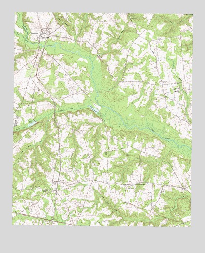
Keysville, GA USGS Topographic Map
Click on map above to begin viewing in our Map Viewer.

This topographic map contains these locations and features:
Feature Name Type Latitude Longitude GNIS ID View Map
Blackburn ChurchChurchN33.1493°W82.1687°354756View Map
Boggs AcademySchoolN33.1482°W82.1671°311598View Map
Brushy CreekStreamN33.1938°W82.1823°354882View Map
Brushy Creek (historical)Populated PlaceN33.1968°W82.2201°347943View Map
Brushy Creek CemeteryCemeteryN33.1474°W82.2340°354883View Map
Brushy Creek ChurchChurchN33.1507°W82.2201°354886View Map
Burke County Emergency Management Agency Engine Company 3BuildingN33.2483°W82.2130°2604850View Map
Camp BranchStreamN33.2357°W82.2062°354959View Map
Carswell School (historical)SchoolN33.2351°W82.1476°347954View Map
City of KeysvilleCivilN33.2374°W82.2289°2404828View Map
Clarks Chapel CemeteryCemeteryN33.2385°W82.1654°347959View Map
Clarks Chapel ChurchChurchN33.2390°W82.1646°355175View Map
Davis PondReservoirN33.1901°W82.2232°341560View Map
Davis Pond DamDamN33.1901°W82.2232°341559View Map
Dyes CrossroadPopulated PlaceN33.2107°W82.1460°355583View Map
Faith ChurchChurchN33.2471°W82.2129°347978View Map
Farmers BridgeBridgeN33.2038°W82.1912°314081View Map
George Palmer CemeteryCemeteryN33.2446°W82.1301°347988View Map
Gresham CemeteryCemeteryN33.1674°W82.1682°314886View Map
Hopeful CemeteryCemeteryN33.2093°W82.1340°348003View Map
Hopeful ChurchChurchN33.2060°W82.1373°315633View Map
Hopeful ChurchChurchN33.2096°W82.1340°315634View Map
Hopeful SchoolSchoolN33.2054°W82.1376°315636View Map
James Grove ChurchChurchN33.1346°W82.2396°316041View Map
Keys Grove ChurchChurchN33.1960°W82.2437°316402View Map
Keys PondReservoirN33.1863°W82.2346°316403View Map
Keys Pond DamDamN33.1863°W82.2346°337237View Map
KeysvillePopulated PlaceN33.2338°W82.2323°316404View Map
Keysville CemeteryCemeteryN33.2354°W82.2307°348007View Map
Keysville Community CemeteryCemeteryN33.2407°W82.2262°348008View Map
Keysville DivisionCivilN33.2029°W82.1778°1936344View Map
Keysville Evangelistic ChurchChurchN33.2351°W82.2307°348009View Map
Keysville Post OfficePost OfficeN33.2351°W82.2321°348010View Map
Le Roy (historical)Populated PlaceN33.1343°W82.1537°348011View Map
Little Brushy CreekStreamN33.1904°W82.2248°316967View Map
Little CreekStreamN33.1724°W82.1337°348012View Map
Marks Mill PondReservoirN33.2260°W82.1889°317704View Map
Mill CreekStreamN33.2496°W82.1254°318211View Map
Palmer BranchStreamN33.2276°W82.2093°320162View Map
Palmer Elementary SchoolSchoolN33.2076°W82.2054°348034View Map
Pol Hill CemeteryCemeteryN33.2471°W82.2143°320965View Map
Reedy CreekStreamN33.2346°W82.2418°321467View Map
Saint ClairPopulated PlaceN33.1510°W82.2179°332955View Map
Saint Clair ChurchChurchN33.1460°W82.2246°322053View Map
Saint Clair SchoolSchoolN33.1454°W82.2248°322054View Map
Section Grove ChurchChurchN33.1810°W82.2057°322698View Map
Spring Hill ChurchChurchN33.2471°W82.1682°323435View Map
Spring Hill School (historical)SchoolN33.2468°W82.1685°348062View Map
Stocking BranchStreamN33.1849°W82.1893°348064View Map
Timmons PondReservoirN33.1935°W82.1936°324185View Map
Travers BranchStreamN33.2218°W82.1948°310361View Map
Walker Grove School (historical)SchoolN33.1501°W82.1629°348074View Map
Walker Grove SettlementPopulated PlaceN33.1493°W82.1665°348075View Map
Walkers Grove ChurchChurchN33.1496°W82.1629°324790View Map

Note: Coordinates in the location and feature list above are referenced to NAD83 datum.


Copyright (C) 2008-2025 Ryan Niemi / Sunset Dynamics ... All Rights Reserved