TopoQuest Logo
Do you find TopoQuest useful?
Help keep TopoQuest running and adding new maps/features by donating!
Bitcoin:  19c7KJd3qBynnjoSw5npx9KScwjBe4ifkT
Litecoin:  LXs6TkuXGGXo1vDsWCkWVdjQX94eUKd6ui
Home View Maps Find Maps Find Places Resources & Links


Strawberry, California Topographic Map

USGS Map Title: Strawberry, CA
USGS Map MRC: 38120B1
DRG (GeoTIFF) Download: o38120b1.tif


Neighboring USGS Topographic Map Quads:


  Boards Crossing, CA  
38120C2
 

  Liberty Hill, CA  
38120C1
 

  Donnell Lake, CA  
38119C8
 

  Crandall Peak, CA  
38120B2
 

  Strawberry, CA  
38120B1
 

  Pinecrest, CA  
38119B8
 

  Twain Harte, CA  
38120A2
 

  Hull Creek, CA  
38120A1
 

  Cherry Lake North, CA  
38119A8


Map MRC Location:

N39°
W121°
N39°
W120°
H8 H7 H6 H5 H4 H3 H2 H1
G8 G7 G6 G5 G4 G3 G2 G1
F8 F7 F6 F5 F4 F3 F2 F1
E8 E7 E6 E5 E4 E3 E2 E1
D8 D7 D6 D5 D4 D3 D2 D1
C8 C7 C6 C5 C4 C3 C2 C1
B8 B7 B6 B5 B4 B3 B2 B1
A8 A7 A6 A5 A4 A3 A2 A1
N38°
W121°
N38°
W120°

Strawberry, CA USGS 1:24K Topographic Map Preview:
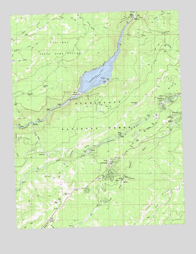
Strawberry, CA USGS Topographic Map
Click on map above to begin viewing in our Map Viewer.

This topographic map contains these locations and features:
Feature Name Type Latitude Longitude GNIS ID View Map
Afterbay DamDamN38.1961°W120.0900°218005View Map
Bald MountainSummitN38.1446°W120.0871°218587View Map
Bald Mountain HeliportAirportN38.1441°W120.0852°1653629View Map
Baptist CampLocaleN38.1394°W120.0607°275146View Map
Beardsley DamDamN38.2041°W120.0752°275137View Map
Beardsley LakeReservoirN38.2148°W120.0608°254593View Map
Beardsley PointCapeN38.2119°W120.0563°218914View Map
Beardsley Point Picnic AreaLocaleN38.2105°W120.0557°275138View Map
Brushy Hollow CreekStreamN38.2371°W120.0432°219951View Map
Bumblebee CreekStreamN38.2355°W120.0177°220142View Map
California Alumni CampLocaleN38.1791°W120.0046°275147View Map
Camp BrayLocaleN38.1880°W120.0246°220444View Map
Camp High SierraLocaleN38.1508°W120.0466°220466View Map
Camp SylvesterLocaleN38.1852°W120.0005°1809343View Map
Chinaman CreekStreamN38.2008°W120.0821°1655229View Map
Cold SpringsPopulated PlaceN38.1624°W120.0532°1658297View Map
Cold Springs Census Designated PlaceCensusN38.1613°W120.0535°2628721View Map
Cow CreekStreamN38.2327°W120.0435°221696View Map
Dodge RidgeRidgeN38.1394°W120.0224°222452View Map
Donnell PowerhouseLocaleN38.2466°W120.0338°1654235View Map
Dry MeadowFlatN38.2235°W120.1232°222658View Map
Fraser FlatFlatN38.1691°W120.0682°223842View Map
Hells Half AcreFlatN38.2469°W120.0344°225134View Map
Helltack BaseLocaleN38.1402°W120.0944°225141View Map
Leland CreekStreamN38.2388°W120.0002°227014View Map
Meadowview CampgroundLocaleN38.1852°W120.0055°228468View Map
Pedro FlatFlatN38.1949°W120.0546°230462View Map
Philadelphia DitchCanalN38.1702°W120.0802°230595View Map
Pinecrest Elementary SchoolSchoolN38.1838°W120.0055°1809373View Map
Pinecrest Treatment PlantLocaleN38.1808°W120.0063°275142View Map
Sierra CampgroundLocaleN38.1544°W120.0446°233084View Map
Sourgrass LakeLakeN38.2080°W120.1037°234917View Map
Sourgrass MeadowFlatN38.2024°W120.1124°234918View Map
Spring GapPopulated PlaceN38.1685°W120.1021°1659844View Map
Spring Gap PowerhouseLocaleN38.1860°W120.1121°1654462View Map
Stanislaus National ForestForestN38.1681°W120.0187°255926View Map
Stoddard SpringSpringN38.1301°W120.1009°235509View Map
StrawberryPopulated PlaceN38.1983°W120.0094°1659884View Map
Strawberry Census Designated PlaceCensusN38.1987°W120.0105°2628792View Map
Strawberry Fire Protection DistrictBuildingN38.1996°W120.0141°2624381View Map
Strawberry Forestry Division Fire StationLocaleN38.1991°W120.0085°275143View Map
Strawberry PeakSummitN38.1963°W120.0321°235586View Map
Strawberry Work CenterLocaleN38.1880°W120.0246°275144View Map
Summit Ranger StationLocaleN38.1880°W120.0080°1682554View Map
Tuolumne County Fire Department Station 55 PinecrestBuildingN38.1881°W120.0044°2624394View Map

Note: Coordinates in the location and feature list above are referenced to NAD83 datum.


Copyright (C) 2008-2024 Ryan Niemi / Sunset Dynamics ... All Rights Reserved