TopoQuest Logo
Do you find TopoQuest useful?
Help keep TopoQuest running and adding new maps/features by donating!
Bitcoin:  19c7KJd3qBynnjoSw5npx9KScwjBe4ifkT
Litecoin:  LXs6TkuXGGXo1vDsWCkWVdjQX94eUKd6ui
Home View Maps Find Maps Find Places Resources & Links


Max Meadows, Virginia Topographic Map

USGS Map Title: Max Meadows, VA
USGS Map MRC: 36080H8
DRG (GeoTIFF) Download: o36080h8.tif


Neighboring USGS Topographic Map Quads:


  Bland, VA  
37081A1
 

  Long Spur, VA  
37080A8
 

  Pulaski, VA  
37080A7
 

  Wytheville, VA  
36081H1
 

  Max Meadows, VA  
36080H8
 

  Fosters Falls, VA  
36080H7
 

  Cripple Creek, VA  
36081G1
 

  Austinville, VA  
36080G8
 

  Sylvatus, VA  
36080G7


Map MRC Location:

N37°
W81°
N37°
W80°
H8 H7 H6 H5 H4 H3 H2 H1
G8 G7 G6 G5 G4 G3 G2 G1
F8 F7 F6 F5 F4 F3 F2 F1
E8 E7 E6 E5 E4 E3 E2 E1
D8 D7 D6 D5 D4 D3 D2 D1
C8 C7 C6 C5 C4 C3 C2 C1
B8 B7 B6 B5 B4 B3 B2 B1
A8 A7 A6 A5 A4 A3 A2 A1
N36°
W81°
N36°
W80°

Max Meadows, VA USGS 1:24K Topographic Map Preview:
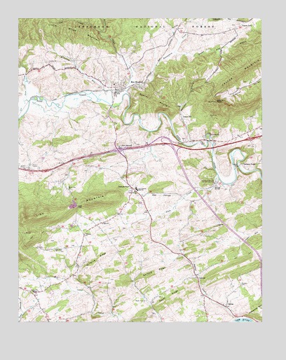
Max Meadows, VA USGS Topographic Map
Click on map above to begin viewing in our Map Viewer.

This topographic map contains these locations and features:
Feature Name Type Latitude Longitude GNIS ID View Map
Beaverdam CreekStreamN36.9743°W80.9412°1481568View Map
Boiling SpringSpringN36.9306°W80.8963°1481908View Map
Brown Lick BranchStreamN36.9862°W80.9192°1482038View Map
Carter WaysideParkN36.9512°W80.9023°1482353View Map
Clarkes SummitPopulated PlaceN36.9960°W80.8890°1501285View Map
Cleveland Mill (historical)LocaleN36.9404°W80.8865°1501286View Map
Coal CreekStreamN36.9948°W80.9579°1482602View Map
Coleman StorePopulated PlaceN36.8862°W80.9915°1501287View Map
ConnersPopulated PlaceN36.9735°W80.9042°1501288View Map
Connor Valley School (historical)SchoolN36.9748°W80.8756°1501289View Map
Cove CreekStreamN36.9657°W80.9945°1482737View Map
Covenant Christian AcademySchoolN36.9365°W80.9450°2498399View Map
Dividing RidgeRidgeN36.9010°W80.9595°1483032View Map
Dungeon BranchStreamN36.8773°W80.9981°1483172View Map
East Piney ChurchChurchN36.9046°W80.9809°1483216View Map
Eastwood BranchStreamN36.8773°W80.9987°1483225View Map
Factory Merchants Mall Shopping CenterLocaleN36.9468°W80.9231°1501296View Map
Farmers StorePopulated PlaceN36.9298°W80.9409°1483380View Map
Fort ChiswellPopulated PlaceN36.9471°W80.9415°1495556View Map
Fort Chiswell Census Designated PlaceCensusN36.9444°W80.9577°2389103View Map
Fort Chiswell ChurchChurchN36.9287°W80.9398°1483494View Map
Fort Chiswell DistrictCivilN36.9648°W80.9182°1927321View Map
Fort Chiswell High SchoolSchoolN36.9297°W80.9392°1483495View Map
Fort Chiswell Middle SchoolSchoolN36.9302°W80.9384°2085813View Map
GalenaPopulated PlaceN36.8812°W80.8931°1483576View Map
Galena CreekStreamN36.8762°W80.8873°1483577View Map
Galena Presbyterian ChurchChurchN36.8823°W80.8948°1501306View Map
Glade CreekStreamN36.9354°W80.8973°1483652View Map
Graham BranchStreamN36.9990°W80.9126°1483735View Map
Grahams ForgePopulated PlaceN36.9398°W80.8848°1495603View Map
Grahams Forge United Methodist ChurchChurchN36.9398°W80.8859°1501310View Map
Gravley ChurchChurchN36.9148°W80.8970°1483771View Map
Hamilton KnobSummitN36.9657°W80.8976°1495647View Map
Horseshoe BendBendN36.9523°W80.9026°1501317View Map
Interchange 32CrossingN36.9482°W80.9212°1501320View Map
Interchange 80CrossingN36.9460°W80.9492°1501325View Map
Interchange 81CrossingN36.9482°W80.9212°1501326View Map
Interchange 84CrossingN36.9504°W80.8812°1501327View Map
Jacob McGavock CemeteryCemeteryN36.9740°W80.9559°1501330View Map
James McGavock CemeteryCemeteryN36.9476°W80.9245°1501331View Map
Keesline BridgeBridgeN36.9487°W80.9159°1501332View Map
Kessling School (historical)SchoolN36.9493°W80.9148°1501334View Map
LaswellPopulated PlaceN36.8943°W80.9090°1484669View Map
Lead Mines DistrictCivilN36.8800°W80.8893°1927370View Map
Lead Mines Rescue SquadBuildingN36.9228°W80.9355°2085809View Map
Little Brush MountainSummitN36.9965°W80.9731°1495845View Map
Locust HillPopulated PlaceN36.9585°W80.9151°1495858View Map
Locust Hill United Methodist ChurchChurchN36.9607°W80.9165°1501341View Map
Lots GapGapN36.9226°W80.9695°1485093View Map
Mathews School (historical)SchoolN36.9193°W80.9106°1501343View Map
Max MeadowsPopulated PlaceN36.9704°W80.9495°1485232View Map
Max Meadows Census Designated PlaceCensusN36.9798°W80.9678°2390137View Map
Max Meadows Elementary SchoolSchoolN36.9730°W80.9512°1501344View Map
Max Meadows Post OfficePost OfficeN36.9702°W80.9493°2780809View Map
Max Meadows Volunteer Fire DepartmentBuildingN36.9529°W80.9507°2085844View Map
McGavock RunStreamN36.9660°W80.9545°1485296View Map
Miller CreekStreamN36.9693°W80.9440°1485467View Map
Mount Vale ChurchChurchN36.9296°W80.9740°1485647View Map
PoletownPopulated PlaceN36.9640°W80.9167°1501354View Map
Poletown BranchStreamN36.9482°W80.9092°1486318View Map
Ramsay MountainSummitN36.9657°W80.9298°1496127View Map
Raper RidgeRidgeN36.8857°W80.9231°1486507View Map
Red HollowValleyN36.9268°W80.9152°1486537View Map
Saint Pauls ChurchChurchN36.9154°W80.9573°1486877View Map
Sanders CemeteryCemeteryN36.8898°W80.8856°1486926View Map
Sanders RidgeRidgeN36.8960°W80.9287°1486929View Map
Sheffey Elementary SchoolSchoolN36.8874°W80.9922°1487172View Map
SiloamPopulated PlaceN36.9107°W80.9662°1487242View Map
Siloam Gospel TabernacleChurchN36.9112°W80.9662°1501367View Map
Summit Hill Church (historical)ChurchN36.9973°W80.8865°1501372View Map
Virginia State Police Division 4 HeadquartersBuildingN36.9387°W80.9974°2773438View Map
Walton FurnacePopulated PlaceN36.8837°W80.9345°1496372View Map
Walton School (historical)SchoolN36.8862°W80.9359°1501376View Map
Wytheville National Fish Hatchery Number 2LocaleN36.9323°W80.8987°1491248View Map

Note: Coordinates in the location and feature list above are referenced to NAD83 datum.


Copyright (C) 2008-2025 Ryan Niemi / Sunset Dynamics ... All Rights Reserved