TopoQuest Logo
Do you find TopoQuest useful?
Help keep TopoQuest running and adding new maps/features by donating!
Bitcoin:  19c7KJd3qBynnjoSw5npx9KScwjBe4ifkT
Litecoin:  LXs6TkuXGGXo1vDsWCkWVdjQX94eUKd6ui
Home View Maps Find Maps Find Places Resources & Links


Summerfield, Ohio Topographic Map

USGS Map Title: Summerfield, OH
USGS Map MRC: 39081G3
DRG (GeoTIFF) Download: o39081g3.tif


Neighboring USGS Topographic Map Quads:


  Senecaville, OH  
39081H4
 

  Quaker City, OH  
39081H3
 

  Barnesville, OH  
39081H2
 

  Sarahsville, OH  
39081G4
 

  Summerfield, OH  
39081G3
 

  Lewisville, OH  
39081G2
 

  Macksburg, OH  
39081F4
 

  Stafford, OH  
39081F3
 

  Graysville, OH  
39081F2


Map MRC Location:

N40°
W82°
N40°
W81°
H8 H7 H6 H5 H4 H3 H2 H1
G8 G7 G6 G5 G4 G3 G2 G1
F8 F7 F6 F5 F4 F3 F2 F1
E8 E7 E6 E5 E4 E3 E2 E1
D8 D7 D6 D5 D4 D3 D2 D1
C8 C7 C6 C5 C4 C3 C2 C1
B8 B7 B6 B5 B4 B3 B2 B1
A8 A7 A6 A5 A4 A3 A2 A1
N39°
W82°
N39°
W81°

Summerfield, OH USGS 1:24K Topographic Map Preview:
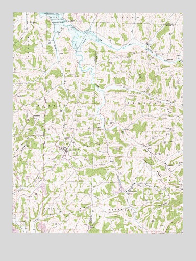
Summerfield, OH USGS Topographic Map
Click on map above to begin viewing in our Map Viewer.

This topographic map contains these locations and features:
Feature Name Type Latitude Longitude GNIS ID View Map
Aaron CemeteryCemeteryN39.8411°W81.2929°1075241View Map
Bates Hill ChurchChurchN39.8692°W81.3615°1075316View Map
Berne Compressor StationLocaleN39.7734°W81.2918°1075350View Map
Bethesda CemeteryCemeteryN39.8695°W81.3331°1075368View Map
Bishop RunStreamN39.7962°W81.3057°1075387View Map
Bracken ChurchChurchN39.7745°W81.2634°1075431View Map
Bracken RidgeRidgeN39.7856°W81.2748°1075432View Map
Bracken Ridge CemeteryCemeteryN39.7748°W81.2632°1963749View Map
BristerPopulated PlaceN39.7976°W81.2762°1075444View Map
Brister CemeteryCemeteryN39.8253°W81.2626°1963750View Map
Brister Post Office (historical)Post OfficeN39.7973°W81.2762°2037280View Map
BurkhartPopulated PlaceN39.7892°W81.2629°1075484View Map
Burkhart Post Office (historical)Post OfficeN39.7890°W81.2623°2037282View Map
CalaisPopulated PlaceN39.8570°W81.2762°1075505View Map
Calais CemeteryCemeteryN39.8492°W81.2747°1075506View Map
Calais Post Office (historical)Post OfficeN39.8570°W81.2771°2037285View Map
Chapel Hill CemeteryCemeteryN39.8091°W81.2583°1075563View Map
Christman QuarryMineN39.7842°W81.2997°2543882View Map
Clagg School (historical)SchoolN39.8359°W81.2601°1051004View Map
Curtis Church (historical)ChurchN39.7565°W81.3382°1050969View Map
Curtis RidgeRidgeN39.7634°W81.3282°1075665View Map
Curtis Ridge CemeteryCemeteryN39.7548°W81.3418°1075666View Map
Danford CemeteryCemeteryN39.8120°W81.3037°1075677View Map
Danford School (historical)SchoolN39.8515°W81.3637°1050995View Map
Days School (historical)SchoolN39.7931°W81.2926°1050999View Map
Death RunStreamN39.7717°W81.2921°1075693View Map
DeVoa RunStreamN39.7778°W81.2862°1075687View Map
Dimmerling Dairy FarmLocaleN39.7503°W81.3567°2634698View Map
DohertyPopulated PlaceN39.8090°W81.3093°1079944View Map
Doherty Post Office (historical)Post OfficeN39.8084°W81.3096°2037298View Map
EthelLocaleN39.7901°W81.3046°1077420View Map
Fendley School (historical)SchoolN39.8209°W81.3676°1050970View Map
Glady CemeteryCemeteryN39.8578°W81.3496°1075924View Map
Glady Church (historical)ChurchN39.8578°W81.3498°1050972View Map
Glady School (historical)SchoolN39.8462°W81.3407°1050971View Map
Haga School (historical)SchoolN39.8262°W81.2959°1051000View Map
Hamilton School (historical)SchoolN39.7648°W81.2571°1051002View Map
Hannash CemeteryCemeteryN39.8465°W81.3019°1075997View Map
HerlanPopulated PlaceN39.8087°W81.2937°1076038View Map
Lexington RidgeRidgeN39.7845°W81.3487°1076238View Map
Markle School (historical)SchoolN39.8167°W81.2651°1051003View Map
Mud RunStreamN39.8103°W81.3098°1076479View Map
Paynes ForkStreamN39.8481°W81.2540°1076606View Map
Ranker KnobSummitN39.7981°W81.3009°1076712View Map
Robinson RunStreamN39.7576°W81.2848°1076749View Map
Saint Joseph Catholic ChurchChurchN39.7890°W81.2626°1073267View Map
Seneca Valley ChurchChurchN39.8478°W81.2623°1076861View Map
Skin CreekStreamN39.8315°W81.3093°1076903View Map
South ForkStreamN39.8651°W81.3290°1076936View Map
SteamtownPopulated PlaceN39.8165°W81.3598°1076961View Map
SummerfieldPopulated PlaceN39.7967°W81.3359°1076998View Map
Summerfield Post OfficePost OfficeN39.7973°W81.3359°2041292View Map
Summerfield Volunteer Fire DepartmentBuildingN39.7967°W81.3352°2550419View Map
SwazeyPopulated PlaceN39.7640°W81.2876°1077011View Map
Swazey Methodist CemeteryCemeteryN39.7662°W81.2887°1963806View Map
Swazey Post Office (historical)Post OfficeN39.7640°W81.2873°2037377View Map
Township of MarionCivilN39.8151°W81.3571°1086747View Map
Township of SenecaCivilN39.8298°W81.2786°1086658View Map
Trots School (historical)SchoolN39.8242°W81.3271°1050974View Map
Union Chapel (historical)SchoolN39.8192°W81.3104°1051001View Map
Valley Store (historical)LocaleN39.8590°W81.3321°1050975View Map
Vernon School (historical)SchoolN39.8503°W81.2909°1051005View Map
Village of SummerfieldCivilN39.7969°W81.3355°2399928View Map
WhigvillePopulated PlaceN39.8276°W81.3737°1077174View Map
Whigville CemeteryCemeteryN39.8273°W81.3750°1963701View Map
Whigville Post Office (historical)Post OfficeN39.8278°W81.3735°2041286View Map
Whiteoak School (historical)SchoolN39.7654°W81.3182°1050973View Map
Wise CemeteryCemeteryN39.7753°W81.2504°1963810View Map

Note: Coordinates in the location and feature list above are referenced to NAD83 datum.


Copyright (C) 2008-2024 Ryan Niemi / Sunset Dynamics ... All Rights Reserved