TopoQuest Logo
Do you find TopoQuest useful?
Help keep TopoQuest running and adding new maps/features by donating!
Bitcoin:  19c7KJd3qBynnjoSw5npx9KScwjBe4ifkT
Litecoin:  LXs6TkuXGGXo1vDsWCkWVdjQX94eUKd6ui
Home View Maps Find Maps Find Places Resources & Links


Sunnyhill, Tennessee Topographic Map

USGS Map Title: Sunnyhill, TN
USGS Map MRC: 35089E2
DRG (GeoTIFF) Download: o35089e2.tif


Neighboring USGS Topographic Map Quads:


  Tibbs, TN  
35089F3
 

  Jones, TN  
35089F2
 

  Bells, TN  
35089F1
 

  Brownsville, TN  
35089E3
 

  Sunnyhill, TN  
35089E2
 

  Denmark, TN  
35089E1
 

  Dancyville, TN  
35089D3
 

  Hillville, TN  
35089D2
 

  Mercer, TN  
35089D1


Map MRC Location:

N36°
W90°
N36°
W89°
H8 H7 H6 H5 H4 H3 H2 H1
G8 G7 G6 G5 G4 G3 G2 G1
F8 F7 F6 F5 F4 F3 F2 F1
E8 E7 E6 E5 E4 E3 E2 E1
D8 D7 D6 D5 D4 D3 D2 D1
C8 C7 C6 C5 C4 C3 C2 C1
B8 B7 B6 B5 B4 B3 B2 B1
A8 A7 A6 A5 A4 A3 A2 A1
N35°
W90°
N35°
W89°

Sunnyhill, TN USGS 1:24K Topographic Map Preview:
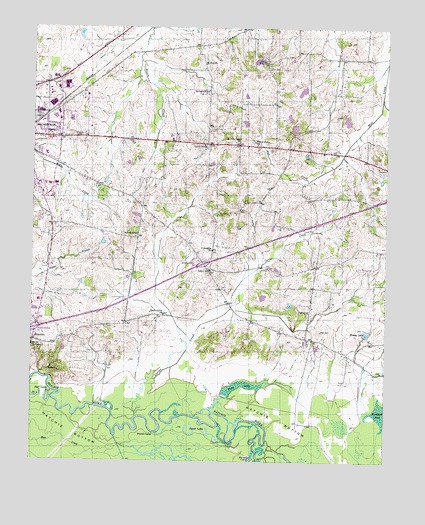
Sunnyhill, TN USGS Topographic Map
Click on map above to begin viewing in our Map Viewer.

This topographic map contains these locations and features:
Feature Name Type Latitude Longitude GNIS ID View Map
Beech Grove CemeteryCemeteryN35.5423°W89.2037°1318952View Map
Beech Grove ChurchChurchN35.5423°W89.2034°1276828View Map
Browns Creek ChurchChurchN35.5920°W89.1776°1305463View Map
Brownsville - Haywood County Ambulance AuthorityBuildingN35.6009°W89.2383°2697407View Map
Brownsville - Haywood County Fire Department District 2BuildingN35.5604°W89.1269°2653854View Map
Brownsville Fire Department Station 2BuildingN35.6002°W89.2399°2653776View Map
Cane CreekStreamN35.6101°W89.1262°1269416View Map
Carter CreekStreamN35.5129°W89.2128°1279811View Map
Chestnut Grove CemeteryCemeteryN35.5953°W89.1534°1280384View Map
Cliff CemeteryCemeteryN35.5428°W89.1514°1318965View Map
Cliff Creek ChurchChurchN35.5431°W89.1520°1305968View Map
Cliff School (historical)SchoolN35.5545°W89.1562°1318966View Map
Cobb Creek LakeReservoirN35.6069°W89.1552°1301955View Map
Cobb Creek Tributary Dam Number 15m-28-2DamN35.6084°W89.1534°1301954View Map
Commissioner District 3CivilN35.5852°W89.2239°2464155View Map
Commissioner District 7CivilN35.5378°W89.1472°2464616View Map
Dezern School (historical)SchoolN35.5898°W89.1876°1318971View Map
East Side Elementary SchoolSchoolN35.5884°W89.2453°1318972View Map
Friendship ChurchChurchN35.5609°W89.1865°1284935View Map
Hart Lake Number TwoLakeN35.5172°W89.2446°1287048View Map
Haywood County Farm (historical)LocaleN35.5906°W89.1892°1318982View Map
Haywood County Memorial GardensCemeteryN35.5917°W89.2187°1318980View Map
Haywood County Sheriff's OfficeBuildingN35.5919°W89.2390°2765838View Map
Haywood High SchoolSchoolN35.6006°W89.2473°1318984View Map
Haywood Park Community HospitalHospitalN35.6105°W89.2430°1318986View Map
Holt DamDamN35.6151°W89.1717°1301966View Map
Holt LakeReservoirN35.6156°W89.1707°1301967View Map
Interchange 56CrossingN35.5381°W89.2487°1311324View Map
Interchange 60CrossingN35.5570°W89.1895°1311325View Map
Knights of Pythias CemeteryCemeteryN35.5992°W89.2484°1290374View Map
Lester SchoolSchoolN35.5554°W89.1873°1291044View Map
Magnolia CemeteryCemeteryN35.5940°W89.2451°1292501View Map
Marvin ChapelChurchN35.5651°W89.2131°1292854View Map
Massey LakeReservoirN35.5374°W89.1320°1292912View Map
Mount Zion ChurchChurchN35.6145°W89.1898°1294881View Map
Powell CampLocaleN35.5081°W89.2070°1298397View Map
Powell DamDamN35.5967°W89.1384°1301949View Map
Powell LakeReservoirN35.5988°W89.1395°1301948View Map
Powell LakesLakeN35.5079°W89.1937°1298420View Map
Richards CemeteryCemeteryN35.5937°W89.2348°1299329View Map
Saint Paul CemeteryCemeteryN35.5329°W89.2498°1319010View Map
Saint Pauls ChurchChurchN35.5331°W89.2498°1300509View Map
Salem CemeteryCemeteryN35.5548°W89.1870°1319012View Map
Salem Church (historical)ChurchN35.5551°W89.1870°1319013View Map
Shaw LakeSwampN35.5225°W89.1743°1269940View Map
Springfield SchoolSchoolN35.6070°W89.1881°1271146View Map
Stokely DamDamN35.5484°W89.1701°1301913View Map
Stokely LakeReservoirN35.5474°W89.1685°1301914View Map
Sunny Hill Middle SchoolSchoolN35.5462°W89.2478°1319023View Map
SunnyhillPopulated PlaceN35.5348°W89.2492°1271863View Map
Upper Zion ChurchChurchN35.6154°W89.1681°1273312View Map
Walker DamDamN35.5317°W89.1501°1301902View Map
Walker LakeReservoirN35.5332°W89.1494°1301901View Map
WBHT-AM (Brownsville)TowerN35.6084°W89.2445°1639871View Map
Willow GrovePopulated PlaceN35.5915°W89.1773°1647498View Map
Willow Grove SchoolSchoolN35.5915°W89.1709°1274762View Map
Woodland Division (historical)CensusN35.5645°W89.1440°1648771View Map
WTBG-FM (Brownsville)TowerN35.6084°W89.2445°1640055View Map
Zion CemeteryCemeteryN35.6137°W89.1673°1304719View Map

Note: Coordinates in the location and feature list above are referenced to NAD83 datum.


Copyright (C) 2008-2025 Ryan Niemi / Sunset Dynamics ... All Rights Reserved