TopoQuest Logo
Do you find TopoQuest useful?
Help keep TopoQuest running and adding new maps/features by donating!
Bitcoin:  19c7KJd3qBynnjoSw5npx9KScwjBe4ifkT
Litecoin:  LXs6TkuXGGXo1vDsWCkWVdjQX94eUKd6ui
Home View Maps Find Maps Find Places Resources & Links


Dancyville, Tennessee Topographic Map

USGS Map Title: Dancyville, TN
USGS Map MRC: 35089D3
DRG (GeoTIFF) Download: o35089d3.tif


Neighboring USGS Topographic Map Quads:


  Turnpike, TN  
35089E4
 

  Brownsville, TN  
35089E3
 

  Sunnyhill, TN  
35089E2
 

  Stanton, TN  
35089D4
 

  Dancyville, TN  
35089D3
 

  Hillville, TN  
35089D2
 

  Lambert, TN  
35089C4
 

  Laconia, TN  
35089C3
 

  Whiteville, TN  
35089C2


Map MRC Location:

N36°
W90°
N36°
W89°
H8 H7 H6 H5 H4 H3 H2 H1
G8 G7 G6 G5 G4 G3 G2 G1
F8 F7 F6 F5 F4 F3 F2 F1
E8 E7 E6 E5 E4 E3 E2 E1
D8 D7 D6 D5 D4 D3 D2 D1
C8 C7 C6 C5 C4 C3 C2 C1
B8 B7 B6 B5 B4 B3 B2 B1
A8 A7 A6 A5 A4 A3 A2 A1
N35°
W90°
N35°
W89°

Dancyville, TN USGS 1:24K Topographic Map Preview:
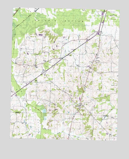
Dancyville, TN USGS Topographic Map
Click on map above to begin viewing in our Map Viewer.

This topographic map contains these locations and features:
Feature Name Type Latitude Longitude GNIS ID View Map
AntiochPopulated PlaceN35.4448°W89.3470°1314587View Map
AsburyPopulated PlaceN35.4495°W89.3323°1314602View Map
Big Ditch BranchStreamN35.4817°W89.2934°1277287View Map
Big Muddy BottomBasinN35.3792°W89.3417°1269339View Map
Big Muddy CanalCanalN35.4067°W89.3506°1277348View Map
Brownsville - Haywood County Fire Department District 10BuildingN35.4291°W89.3438°2654042View Map
Commissioner District 8CivilN35.4492°W89.2797°2464678View Map
DancyvillePopulated PlaceN35.4079°W89.2940°1282015View Map
Dancyville CemeteryCemeteryN35.4173°W89.3065°1318969View Map
Dancyville CemeteryCemeteryN35.4048°W89.2948°1326482View Map
Dancyville School (historical)SchoolN35.4067°W89.2942°1318970View Map
Dancyville United Methodist ChurchChurchN35.4054°W89.2956°1326483View Map
Douglass ChapelChurchN35.4440°W89.3473°1282746View Map
Douglass SchoolSchoolN35.4309°W89.3453°1282750View Map
Hickory PointPopulated PlaceN35.4451°W89.2965°1315231View Map
Interchange 47CrossingN35.4387°W89.3367°1311322View Map
Interchange 52CrossingN35.4790°W89.2745°1311323View Map
Jeter CreekStreamN35.4676°W89.3101°1289417View Map
Jeter HillSummitN35.4279°W89.2540°1289418View Map
Jones CemeteryCemeteryN35.3970°W89.2551°1289715View Map
Ko KoPopulated PlaceN35.4790°W89.2717°1290405View Map
McKenzie ChapelChurchN35.4490°W89.3351°1293361View Map
Morton HillPopulated PlaceN35.4715°W89.2887°1315539View Map
North Fork Price BranchStreamN35.3817°W89.3148°1295909View Map
Pat Mann DamDamN35.4017°W89.3234°1301804View Map
Pat Mann LakeReservoirN35.4036°W89.3219°1301803View Map
Poplar CreekStreamN35.4998°W89.2726°1298182View Map
Prairie CreekStreamN35.4845°W89.3053°1298446View Map
Price BranchStreamN35.3895°W89.3387°1298493View Map
ProspectPopulated PlaceN35.4565°W89.2756°1311332View Map
Prospect CemeteryCemeteryN35.4537°W89.2756°1319005View Map
Prospect ChurchChurchN35.4534°W89.2759°1298580View Map
Reeves SchoolSchoolN35.3901°W89.3617°1299191View Map
Richmond HillSummitN35.4492°W89.2806°1299373View Map
Saint JohnPopulated PlaceN35.4392°W89.2845°1311333View Map
Saint John CemeteryCemeteryN35.4398°W89.2867°1319008View Map
Saint John ChurchChurchN35.4404°W89.2867°1651140View Map
Saint Johns SchoolSchoolN35.4401°W89.2859°1300454View Map
Scratchunder CemeteryCemeteryN35.4990°W89.2940°1300970View Map
Spring HillPopulated PlaceN35.4509°W89.2770°1314325View Map
Spring Hill CemeteryCemeteryN35.4506°W89.2728°1319020View Map
Spring Hill ChurchChurchN35.4504°W89.2723°1319021View Map
Stanton Division (historical)CensusN35.4573°W89.3676°1648770View Map
Wilkinson CornerPopulated PlaceN35.4523°W89.3184°1314510View Map
Willett School (historical)SchoolN35.3895°W89.2695°1319937View Map
WillisPopulated PlaceN35.4787°W89.2773°1314514View Map
Willis School (historical)SchoolN35.4790°W89.2776°1319029View Map
Zu ZuPopulated PlaceN35.3904°W89.3567°1647508View Map

Note: Coordinates in the location and feature list above are referenced to NAD83 datum.


Copyright (C) 2008-2025 Ryan Niemi / Sunset Dynamics ... All Rights Reserved