TopoQuest Logo
Do you find TopoQuest useful?
Help keep TopoQuest running and adding new maps/features by donating!
Bitcoin:  19c7KJd3qBynnjoSw5npx9KScwjBe4ifkT
Litecoin:  LXs6TkuXGGXo1vDsWCkWVdjQX94eUKd6ui
Home View Maps Find Maps Find Places Resources & Links


Brownsville, Tennessee Topographic Map

USGS Map Title: Brownsville, TN
USGS Map MRC: 35089E3
DRG (GeoTIFF) Download: o35089e3.tif


Neighboring USGS Topographic Map Quads:


  Durhamville, TN  
35089F4
 

  Tibbs, TN  
35089F3
 

  Jones, TN  
35089F2
 

  Turnpike, TN  
35089E4
 

  Brownsville, TN  
35089E3
 

  Sunnyhill, TN  
35089E2
 

  Stanton, TN  
35089D4
 

  Dancyville, TN  
35089D3
 

  Hillville, TN  
35089D2


Map MRC Location:

N36°
W90°
N36°
W89°
H8 H7 H6 H5 H4 H3 H2 H1
G8 G7 G6 G5 G4 G3 G2 G1
F8 F7 F6 F5 F4 F3 F2 F1
E8 E7 E6 E5 E4 E3 E2 E1
D8 D7 D6 D5 D4 D3 D2 D1
C8 C7 C6 C5 C4 C3 C2 C1
B8 B7 B6 B5 B4 B3 B2 B1
A8 A7 A6 A5 A4 A3 A2 A1
N35°
W90°
N35°
W89°

Brownsville, TN USGS 1:24K Topographic Map Preview:
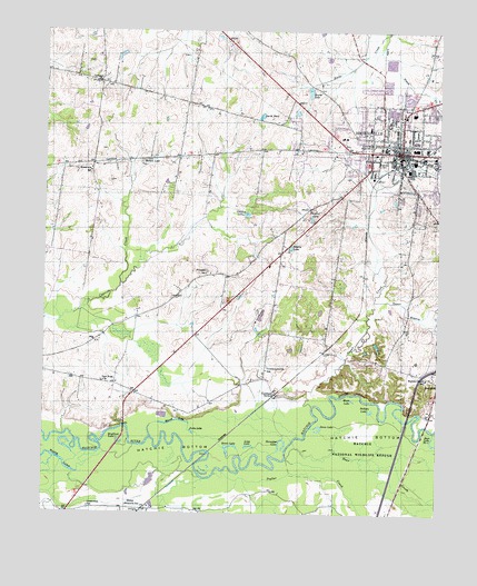
Brownsville, TN USGS Topographic Map
Click on map above to begin viewing in our Map Viewer.

This topographic map contains these locations and features:
Feature Name Type Latitude Longitude GNIS ID View Map
A C Veirs DamDamN35.6201°W89.3501°1301971View Map
A C Veirs LakeReservoirN35.6189°W89.3506°1301970View Map
Anderson Grammar SchoolSchoolN35.5912°W89.2706°1318949View Map
B W Cobb LakeReservoirN35.6101°W89.2701°1301960View Map
B W Cobb Lake DamDamN35.6101°W89.2701°1301961View Map
Bear CreekStreamN35.5142°W89.2978°1269322View Map
Berson LakeLakeN35.5911°W89.3446°1277067View Map
Bomer City ParkParkN35.5954°W89.2506°1318956View Map
Bomer LakeReservoirN35.6093°W89.2914°1277922View Map
Bradford LakeLakeN35.5184°W89.3511°1278169View Map
Bradford Square Shopping CenterLocaleN35.5948°W89.2576°1318957View Map
BrownsvillePopulated PlaceN35.5940°W89.2623°1278634View Map
Brownsville - Haywood County Fire Department District 5BuildingN35.5849°W89.3595°2654224View Map
Brownsville Baptist ChurchChurchN35.5942°W89.2642°1318959View Map
Brownsville City HallBuildingN35.5954°W89.2628°1647989View Map
Brownsville Country ClubLocaleN35.5917°W89.3045°1318960View Map
Brownsville Division (historical)CensusN35.5951°W89.2606°1648765View Map
Brownsville Fire Department Station 1BuildingN35.5950°W89.2624°2653676View Map
Brownsville Fire Department Station 3BuildingN35.5933°W89.2887°2654098View Map
Brownsville Police DepartmentBuildingN35.5951°W89.2627°2765851View Map
Brownsville Post OfficePost OfficeN35.5926°W89.2518°1651128View Map
Brownsville-Haywood County LibraryBuildingN35.5942°W89.2637°1318961View Map
Bucks CreekStreamN35.6245°W89.2673°1278889View Map
Bullpen LakeLakeN35.5266°W89.2712°1278974View Map
Calvary Baptist ChurchChurchN35.5870°W89.2595°1647990View Map
Carver High School (historical)SchoolN35.5923°W89.2556°1647991View Map
Christ Episcopal ChurchChurchN35.5956°W89.2620°1647992View Map
Church of ChristChurchN35.5956°W89.2634°1647993View Map
Church of ChristChurchN35.5929°W89.2598°1647994View Map
Church of God in ChristChurchN35.5931°W89.2603°1647995View Map
City of BrownsvilleCivilN35.5881°W89.2575°2403941View Map
College Hill Community CenterBuildingN35.5959°W89.2717°1318967View Map
College Hill Historic DistrictParkN35.5940°W89.2717°1326481View Map
Commissioner District 1CivilN35.6067°W89.2621°2464243View Map
Commissioner District 4CivilN35.6031°W89.2731°2464046View Map
Cuthbert SwitchLocaleN35.5309°W89.3017°1306248View Map
Cuthbert Switch SchoolSchoolN35.5373°W89.3048°1281909View Map
Drain LakeLakeN35.5158°W89.3164°1282770View Map
Farmers Chapel Christian Methodist Episcopal ChurchChurchN35.5951°W89.2642°1647996View Map
First Baptist Church of BrownsvilleChurchN35.5929°W89.2590°1647997View Map
First Methodist ChurchChurchN35.5954°W89.2609°1647998View Map
First Presbyterian Church of BrownsvilleChurchN35.5962°W89.2634°1647999View Map
Greenwood SchoolSchoolN35.5017°W89.3603°1286210View Map
Harris CemeteryCemeteryN35.5906°W89.3448°1647493View Map
Hart Lake Number OneLakeN35.5183°W89.2507°1287047View Map
Haynes Chapel SchoolSchoolN35.5354°W89.2537°1287232View Map
Haywood CountyCivilN35.5832°W89.2838°1639753View Map
Haywood County CourthouseBuildingN35.5937°W89.2626°1318981View Map
Haywood County JailBuildingN35.5920°W89.2615°1648000View Map
Haywood County Memorial HospitalHospitalN35.5965°W89.2667°1648001View Map
Haywood Elementary SchoolSchoolN35.6001°W89.2723°1318983View Map
Haywood HeightsPopulated PlaceN35.5909°W89.2715°1648002View Map
Haywood Junior High SchoolSchoolN35.5976°W89.2806°1318985View Map
Horseshoe LakeLakeN35.5175°W89.2985°1288447View Map
Israel CemeteryCemeteryN35.6037°W89.2503°1289110View Map
Jacks LakeLakeN35.5212°W89.3277°1289176View Map
Johnson LakeLakeN35.5776°W89.3111°1289641View Map
LebanonPopulated PlaceN35.6117°W89.3576°1311327View Map
Lebanon CemeteryCemeteryN35.6115°W89.3587°1318994View Map
Lebanon ChurchChurchN35.6117°W89.3581°1290849View Map
Lebanon School (historical)SchoolN35.6129°W89.3578°1318995View Map
Long LakeLakeN35.5176°W89.3098°1291984View Map
MacedoniaPopulated PlaceN35.5906°W89.3598°1647494View Map
Macedonia ChurchChurchN35.5892°W89.3606°1318999View Map
Macedonia SchoolSchoolN35.5884°W89.3606°1292426View Map
Moon LakeLakeN35.5296°W89.2769°1294227View Map
Moores LakeLakeN35.5240°W89.3334°1294317View Map
New Hope ChurchChurchN35.5342°W89.3559°1295528View Map
Oakwood CemeteryCemeteryN35.5906°W89.2681°1296211View Map
Patton SchoolSchoolN35.6070°W89.3303°1296987View Map
Prospect CemeteryCemeteryN35.5629°W89.3237°1319006View Map
Prospect ChurchChurchN35.5623°W89.3226°1319007View Map
Prospect SchoolSchoolN35.5623°W89.3240°1298586View Map
Rosenwald CemeteryCemeteryN35.5919°W89.2501°1300103View Map
Saint Johns Roman Catholic ChurchChurchN35.6020°W89.2615°1648003View Map
Selaris LakeLakeN35.5690°W89.2970°1301038View Map
Shaws Chapel SchoolSchoolN35.5434°W89.2870°1269943View Map
SheppPopulated PlaceN35.5012°W89.3465°1303567View Map
Shepp School (historical)SchoolN35.5012°W89.3395°1319017View Map
Smith PondReservoirN35.6030°W89.3068°1270703View Map
Sonny Jernigen DamDamN35.5484°W89.3067°1301916View Map
Sonny Jernigen LakeReservoirN35.5484°W89.3067°1301915View Map
Sugar BranchStreamN35.5554°W89.2706°1271640View Map
Sugar CreekStreamN35.5281°W89.2895°1271671View Map
Swan LakeLakeN35.5219°W89.2872°1271941View Map
Temple Adas IsraelChurchN35.5956°W89.2617°1326484View Map
Turpine LakeReservoirN35.5767°W89.2904°1273104View Map
Wesley LakesLakeN35.5144°W89.3705°1274125View Map
Wilson School (historical)SchoolN35.5937°W89.3212°1319030View Map
Zion ChurchChurchN35.5956°W89.2626°1326485View Map

Note: Coordinates in the location and feature list above are referenced to NAD83 datum.


Copyright (C) 2008-2024 Ryan Niemi / Sunset Dynamics ... All Rights Reserved