TopoQuest Logo
Do you find TopoQuest useful?
Help keep TopoQuest running and adding new maps/features by donating!
Bitcoin:  19c7KJd3qBynnjoSw5npx9KScwjBe4ifkT
Litecoin:  LXs6TkuXGGXo1vDsWCkWVdjQX94eUKd6ui
Home View Maps Find Maps Find Places Resources & Links


Sunset Crater West, Arizona Topographic Map

USGS Map Title: Sunset Crater West, AZ
USGS Map MRC: 35111C5
DRG (GeoTIFF) Download: o35111c5.tif


Neighboring USGS Topographic Map Quads:


  White Horse Hills, AZ  
35111D6
 

  O'Leary Peak, AZ  
35111D5
 

  Strawberry Crater, AZ  
35111D4
 

  Humphreys Peak, AZ  
35111C6
 

  Sunset Crater West, AZ  
35111C5
 

  Sunset Crater East, AZ  
35111C4
 

  Flagstaff West, AZ  
35111B6
 

  Flagstaff East, AZ  
35111B5
 

  Winona, AZ  
35111B4


Map MRC Location:

N36°
W112°
N36°
W111°
H8 H7 H6 H5 H4 H3 H2 H1
G8 G7 G6 G5 G4 G3 G2 G1
F8 F7 F6 F5 F4 F3 F2 F1
E8 E7 E6 E5 E4 E3 E2 E1
D8 D7 D6 D5 D4 D3 D2 D1
C8 C7 C6 C5 C4 C3 C2 C1
B8 B7 B6 B5 B4 B3 B2 B1
A8 A7 A6 A5 A4 A3 A2 A1
N35°
W112°
N35°
W111°

Sunset Crater West, AZ USGS 1:24K Topographic Map Preview:
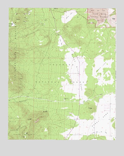
Sunset Crater West, AZ USGS Topographic Map
Click on map above to begin viewing in our Map Viewer.

This topographic map contains these locations and features:
Feature Name Type Latitude Longitude GNIS ID View Map
Black Bill ParkFlatN35.3128°W111.5443°26368View Map
Black Bill TankReservoirN35.2681°W111.5668°37651View Map
Bonita Lava FlowLavaN35.3721°W111.5218°2088974View Map
Bonito Lava FlowLavaN35.3714°W111.5229°26599View Map
Bonito ParkFlatN35.3683°W111.5552°26601View Map
Bonito Recreation SiteLocaleN35.3692°W111.5424°37657View Map
Calvary Chapel of FlagstaffChurchN35.2508°W111.5576°2670673View Map
Carden of the Peaks SchoolSchoolN35.2801°W111.5104°2543574View Map
Cinder LakeFlatN35.3197°W111.5171°27656View Map
City of Flagstaff Cinder Lakes LandfillLocaleN35.3085°W111.5172°2671957View Map
Cromer Elementary SchoolSchoolN35.2686°W111.5221°2543568View Map
Deer HillSummitN35.2981°W111.5857°42644View Map
Doney ParkFlatN35.2700°W111.5174°28533View Map
Doney Park Census Designated PlaceCensusN35.2687°W111.5053°2582772View Map
East Valley Baptist ChurchChurchN35.2932°W111.5412°2670877View Map
Eighty-nine TankReservoirN35.3444°W111.5877°42649View Map
Fort Valley Experimental ForestForestN35.2770°W111.5388°42645View Map
Government TankReservoirN35.2886°W111.5602°29457View Map
Interior ValleyValleyN35.3636°W111.6218°30398View Map
J and H Recreational Vehicle ParkLocaleN35.2531°W111.5552°2670188View Map
Jack Smith Spring Number TwoSpringN35.3572°W111.5999°37854View Map
Jack Smith TankReservoirN35.3743°W111.5728°30461View Map
Kachina Peaks WildernessReserveN35.3328°W111.6194°2090081View Map
Lava Flow TrailTrailN35.3622°W111.5154°2025448View Map
Lennox TankReservoirN35.3361°W111.5927°42650View Map
Lenoux TankReservoirN35.3363°W111.5763°37898View Map
Lenox CraterCraterN35.3603°W111.5299°30946View Map
Lenox ParkFlatN35.3431°W111.5640°30947View Map
Lenox TrailTrailN35.3614°W111.5238°2025452View Map
Little Elden MountainSummitN35.2692°W111.5976°31062View Map
Little Elden Sping Horse CampLocaleN35.2792°W111.5790°2089533View Map
Little Elden SpringSpringN35.2769°W111.5795°31063View Map
Little Elden Spring Horse CampLocaleN35.2792°W111.5790°2089778View Map
Locket Meadow TankReservoirN35.3588°W111.6184°42654View Map
Lockett Meadow SpringSpringN35.3603°W111.6208°31164View Map
Lord of Life Lutheran ChurchChurchN35.2687°W111.5220°2671560View Map
Northland Baptist ChurchChurchN35.2548°W111.5561°2671602View Map
NPS VIS CenterLocaleN35.3678°W111.5443°42653View Map
Old Caves CraterCraterN35.2800°W111.5271°32493View Map
Oldham ParkFlatN35.2528°W111.6049°32520View Map
Peaks Ranger DistrictForestN35.3000°W111.6167°2076441View Map
Railroad TankReservoirN35.3136°W111.5662°38024View Map
Silver Saddle Mobile Home ParkPopulated PlaceN35.2708°W111.5466°2669680View Map
Sugarloaf PeakSummitN35.3633°W111.6146°34917View Map
Summit Fire District Station 32BuildingN35.2681°W111.5242°2672637View Map
Summit Fire District Station 33BuildingN35.3111°W111.5420°2672367View Map
Summit TankReservoirN35.3283°W111.5769°42651View Map
Sunset CraterCraterN35.3642°W111.5040°34967View Map
Sunset Crater Volcano National MonumentParkN35.3711°W111.5104°34968View Map
Sunset Crater Volcano National Monument Visitor CenterBuildingN35.3711°W111.5468°2025449View Map
Sunset ParkFlatN35.2561°W111.6046°34973View Map
Thompson TankReservoirN35.2755°W111.5523°38109View Map
Weatherford CanyonValleyN35.2900°W111.5773°35928View Map
Wheel Inn Mobile Home ParkPopulated PlaceN35.2555°W111.5438°2669842View Map

Note: Coordinates in the location and feature list above are referenced to NAD83 datum.


Copyright (C) 2008-2024 Ryan Niemi / Sunset Dynamics ... All Rights Reserved