TopoQuest Logo
Do you find TopoQuest useful?
Help keep TopoQuest running and adding new maps/features by donating!
Bitcoin:  19c7KJd3qBynnjoSw5npx9KScwjBe4ifkT
Litecoin:  LXs6TkuXGGXo1vDsWCkWVdjQX94eUKd6ui
Home View Maps Find Maps Find Places Resources & Links


O'Leary Peak, Arizona Topographic Map

USGS Map Title: O'Leary Peak, AZ
USGS Map MRC: 35111D5
DRG (GeoTIFF) Download: o35111d5.tif


Neighboring USGS Topographic Map Quads:


  S P Mountain, AZ  
35111E6
 

  East of S P Mountain, AZ  
35111E5
 

  Wupatki SW, AZ  
35111E4
 

  White Horse Hills, AZ  
35111D6
 

  O'Leary Peak, AZ  
35111D5
 

  Strawberry Crater, AZ  
35111D4
 

  Humphreys Peak, AZ  
35111C6
 

  Sunset Crater West, AZ  
35111C5
 

  Sunset Crater East, AZ  
35111C4


Map MRC Location:

N36°
W112°
N36°
W111°
H8 H7 H6 H5 H4 H3 H2 H1
G8 G7 G6 G5 G4 G3 G2 G1
F8 F7 F6 F5 F4 F3 F2 F1
E8 E7 E6 E5 E4 E3 E2 E1
D8 D7 D6 D5 D4 D3 D2 D1
C8 C7 C6 C5 C4 C3 C2 C1
B8 B7 B6 B5 B4 B3 B2 B1
A8 A7 A6 A5 A4 A3 A2 A1
N35°
W112°
N35°
W111°

O'Leary Peak, AZ USGS 1:24K Topographic Map Preview:
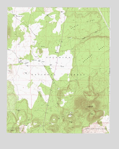
O'Leary Peak, AZ USGS Topographic Map
Click on map above to begin viewing in our Map Viewer.

This topographic map contains these locations and features:
Feature Name Type Latitude Longitude GNIS ID View Map
Alto SpringSpringN35.3775°W111.6206°25612View Map
Bear Jaw CanyonValleyN35.4106°W111.6085°26095View Map
Bedground RidgeRidgeN35.4439°W111.5432°41193View Map
Boswell TankReservoirN35.4348°W111.6006°26630View Map
Carr TankReservoirN35.4391°W111.5699°27302View Map
Cedar RidgeRidgeN35.4839°W111.5346°27432View Map
Chavez TankReservoirN35.4920°W111.5748°27534View Map
Chicos TankReservoirN35.4171°W111.5862°37708View Map
Darton DomeSummitN35.3942°W111.5196°28283View Map
Deadman FlatFlatN35.4603°W111.5632°28335View Map
Deadman MesaSummitN35.4475°W111.5379°28339View Map
Deadman TankReservoirN35.4470°W111.5946°28343View Map
Dove TankReservoirN35.4698°W111.5471°28582View Map
Espil RanchLocaleN35.4453°W111.6088°28920View Map
French TankReservoirN35.4958°W111.5604°2088971View Map
Hostetter TankReservoirN35.3983°W111.6119°30221View Map
Lost TankReservoirN35.3827°W111.5997°31319View Map
Lucky TankReservoirN35.4610°W111.5844°31398View Map
Medicine ValleyValleyN35.3825°W111.5743°37934View Map
O'Leary PeakSummitN35.4017°W111.5263°32421View Map
O'Leary Peak Lookout TowerTowerN35.4017°W111.5265°41196View Map
Old Grand Canyon TankReservoirN35.4920°W111.6148°32504View Map
Osborne TankReservoirN35.4427°W111.5735°32574View Map
Pete TankReservoirN35.4414°W111.5599°32817View Map
Pierre TankReservoirN35.4960°W111.5604°32885View Map
Robinson CraterCraterN35.3928°W111.5474°33681View Map
Robinson MountainSummitN35.3861°W111.5443°33683View Map
Sacred Mountain Trading PostLocaleN35.4550°W111.5632°33922View Map
Sawmill TankReservoirN35.3986°W111.5635°2088973View Map
Sinagua ValleyValleyN35.4314°W111.5810°34459View Map
Stagg TankReservoirN35.4462°W111.5876°34793View Map
Tank EightReservoirN35.4191°W111.5634°35127View Map
Tank FourReservoirN35.4631°W111.6113°35124View Map
Tank SevenReservoirN35.4028°W111.5813°35126View Map
Tank SixReservoirN35.3881°W111.5993°35125View Map

Note: Coordinates in the location and feature list above are referenced to NAD83 datum.


Copyright (C) 2008-2024 Ryan Niemi / Sunset Dynamics ... All Rights Reserved