TopoQuest Logo
Do you find TopoQuest useful?
Help keep TopoQuest running and adding new maps/features by donating!
Bitcoin:  19c7KJd3qBynnjoSw5npx9KScwjBe4ifkT
Litecoin:  LXs6TkuXGGXo1vDsWCkWVdjQX94eUKd6ui
Home View Maps Find Maps Find Places Resources & Links


White Horse Hills, Arizona Topographic Map

USGS Map Title: White Horse Hills, AZ
USGS Map MRC: 35111D6
DRG (GeoTIFF) Download: o35111d6.tif


Neighboring USGS Topographic Map Quads:


  Chapel Mountain, AZ  
35111E7
 

  S P Mountain, AZ  
35111E6
 

  East of S P Mountain, AZ  
35111E5
 

  Kendrick Peak, AZ  
35111D7
 

  White Horse Hills, AZ  
35111D6
 

  O'Leary Peak, AZ  
35111D5
 

  Wing Mountain, AZ  
35111C7
 

  Humphreys Peak, AZ  
35111C6
 

  Sunset Crater West, AZ  
35111C5


Map MRC Location:

N36°
W112°
N36°
W111°
H8 H7 H6 H5 H4 H3 H2 H1
G8 G7 G6 G5 G4 G3 G2 G1
F8 F7 F6 F5 F4 F3 F2 F1
E8 E7 E6 E5 E4 E3 E2 E1
D8 D7 D6 D5 D4 D3 D2 D1
C8 C7 C6 C5 C4 C3 C2 C1
B8 B7 B6 B5 B4 B3 B2 B1
A8 A7 A6 A5 A4 A3 A2 A1
N35°
W112°
N35°
W111°

White Horse Hills, AZ USGS 1:24K Topographic Map Preview:
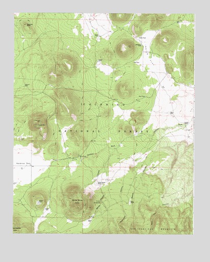
White Horse Hills, AZ USGS Topographic Map
Click on map above to begin viewing in our Map Viewer.

This topographic map contains these locations and features:
Feature Name Type Latitude Longitude GNIS ID View Map
Aubineau CanyonValleyN35.4167°W111.6721°25840View Map
Badger TankReservoirN35.4727°W111.6922°25884View Map
Black TankReservoirN35.3819°W111.6624°37654View Map
Bonita TankReservoirN35.4872°W111.6917°26596View Map
Borrego Trick TankReservoirN35.4489°W111.6993°37659View Map
Deep TankReservoirN35.4859°W111.7327°37742View Map
Elizabeth TankReservoirN35.3856°W111.6938°41214View Map
Geyler TankReservoirN35.3888°W111.7283°29312View Map
Goat TankReservoirN35.4957°W111.6356°29363View Map
Hall TankReservoirN35.4723°W111.6677°29697View Map
Howard SeepSpringN35.4588°W111.7426°30255View Map
Howard Seep TankReservoirN35.4591°W111.7429°37845View Map
Indian FlatFlatN35.4750°W111.6571°30339View Map
Indian TankReservoirN35.4858°W111.6641°30384View Map
Kelly TankReservoirN35.4186°W111.7047°30730View Map
Kendrick Park Forest Service StationBuildingN35.4225°W111.7377°41215View Map
Kendrick TankReservoirN35.4113°W111.7296°37876View Map
Lavin TankReservoirN35.4437°W111.6421°30909View Map
Lookout TankReservoirN35.4375°W111.6296°31281View Map
Maverick ButteSummitN35.4931°W111.7421°31576View Map
McKinney TankReservoirN35.4819°W111.6623°31677View Map
Pat SpringSpringN35.3926°W111.6899°32724View Map
Pat TankReservoirN35.3851°W111.6946°32725View Map
Pat TankReservoirN35.3906°W111.6901°37981View Map
Pete Number One TankReservoirN35.4178°W111.6604°37985View Map
Potato TankReservoirN35.3827°W111.6984°33147View Map
Reese CanyonValleyN35.4364°W111.6313°33556View Map
Reese TanksReservoirN35.3925°W111.6693°33557View Map
Road TankReservoirN35.4525°W111.6595°33660View Map
Saddle MountainSummitN35.4361°W111.7346°33927View Map
Saddle Trick TankReservoirN35.4395°W111.7240°2088970View Map
Tub Number OneReservoirN35.3933°W111.6896°35484View Map
Tub Number ThreeReservoirN35.4322°W111.6635°35486View Map
Tub Number TwoReservoirN35.4056°W111.6835°35485View Map
Walker LakeLakeN35.3926°W111.7326°35829View Map
White Horse CanyonValleyN35.4250°W111.6763°36074View Map
White Horse HillsSummitN35.3895°W111.7043°36075View Map
Yellow Jacket TankReservoirN35.4035°W111.6918°36464View Map

Note: Coordinates in the location and feature list above are referenced to NAD83 datum.


Copyright (C) 2008-2024 Ryan Niemi / Sunset Dynamics ... All Rights Reserved