TopoQuest Logo
Do you find TopoQuest useful?
Help keep TopoQuest running and adding new maps/features by donating!
Bitcoin:  19c7KJd3qBynnjoSw5npx9KScwjBe4ifkT
Litecoin:  LXs6TkuXGGXo1vDsWCkWVdjQX94eUKd6ui
Home View Maps Find Maps Find Places Resources & Links


Suwannee, Florida Topographic Map

USGS Map Title: Suwannee, FL
USGS Map MRC: 29083C2
DRG (GeoTIFF) Download: o29083c2.tif


Neighboring USGS Topographic Map Quads:


  Horseshoe Beach, FL  
29083D3
 

  Shired Island, FL  
29083D2
 

  Vista, FL  
29083D1


  Suwannee, FL  
29083C2
 

  East Pass, FL  
29083C1


  Cedar Key, FL  
29083B1


Map MRC Location:

N30°
W84°
N30°
W83°
H8 H7 H6 H5 H4 H3 H2 H1
G8 G7 G6 G5 G4 G3 G2 G1
F8 F7 F6 F5 F4 F3 F2 F1
E8 E7 E6 E5 E4 E3 E2 E1
D8 D7 D6 D5 D4 D3 D2 D1
C8 C7 C6 C5 C4 C3 C2 C1
B8 B7 B6 B5 B4 B3 B2 B1
A8 A7 A6 A5 A4 A3 A2 A1
N29°
W84°
N29°
W83°

Suwannee, FL USGS 1:24K Topographic Map Preview:
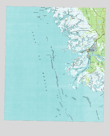
Suwannee, FL USGS Topographic Map
Click on map above to begin viewing in our Map Viewer.

This topographic map contains these locations and features:
Feature Name Type Latitude Longitude GNIS ID View Map
Alligator PassChannelN29.2997°W83.1596°277799View Map
Axe IslandIslandN29.3133°W83.1735°278010View Map
Barbree IslandIslandN29.3263°W83.1521°278100View Map
Big Magnesia CreekStreamN29.3161°W83.1290°278708View Map
Bird Island CreekStreamN29.2930°W83.1532°278806View Map
Boiler GapChannelN29.3183°W83.1901°279185View Map
Bradford IslandIslandN29.3169°W83.1521°279314View Map
Bumblebee CreekStreamN29.3552°W83.1849°279663View Map
Bumblebee IslandIslandN29.3630°W83.1674°279665View Map
Cat IslandIslandN29.3283°W83.1768°280129View Map
Coon IslandIslandN29.3650°W83.2026°280757View Map
Crutchman IslandIslandN29.3638°W83.2065°281112View Map
Demory CreekStreamN29.3252°W83.1390°281495View Map
Goodson IslandIslandN29.3180°W83.1601°283181View Map
Halfmoon ReefBarN29.2733°W83.1437°283605View Map
Harden CreekStreamN29.3108°W83.1429°283726View Map
Harris CreekStreamN29.3277°W83.1649°283764View Map
Harris IslandIslandN29.3269°W83.1612°283766View Map
Hog IslandIslandN29.3069°W83.1340°284087View Map
Hog Island CreekStreamN29.2866°W83.1410°284088View Map
Little Bird IslandIslandN29.3688°W83.2085°285602View Map
Little Bradford IslandIslandN29.3100°W83.1665°285622View Map
Little Bumblebee IslandIslandN29.3616°W83.1724°285629View Map
Little Harden CreekStreamN29.3147°W83.1423°285705View Map
Little Magnesia CreekStreamN29.3166°W83.1326°285735View Map
Little Pine IslandIslandN29.3713°W83.2012°285758View Map
Lock CreekStreamN29.3225°W83.1287°285904View Map
Magnesia PassChannelN29.3180°W83.1346°286286View Map
Mitchell CreekStreamN29.2789°W83.1298°304915View Map
Moccasin CreekStreamN29.2844°W83.1354°287034View Map
Monden CampLocaleN29.3436°W83.1273°298054View Map
North Double Barrel CreekStreamN29.3475°W83.1743°287804View Map
Northern PassChannelN29.3133°W83.1637°287882View Map
Odulund IslandIslandN29.3141°W83.1618°288056View Map
Palm IslandIslandN29.3322°W83.1696°288405View Map
Perpetual Wildlife Management AreaParkN29.3552°W83.1462°304922View Map
Ranch Bar GapChannelN29.2552°W83.1843°293069View Map
Salt CreekStreamN29.3252°W83.1590°290430View Map
Salt Creek ChurchChurchN29.3288°W83.1482°300243View Map
Sanders CreekStreamN29.3730°W83.2015°290592View Map
South Double Barrel CreekStreamN29.3455°W83.1718°291368View Map
SuwanneePopulated PlaceN29.3288°W83.1443°291907View Map
Suwannee Post OfficePost OfficeN29.3292°W83.1475°2783385View Map
Suwannee ReefBarN29.2689°W83.1762°291912View Map
Suwannee RiverStreamN29.2883°W83.1660°308455View Map
Wadley PassChannelN29.3052°W83.1685°299067View Map
West PassChannelN29.3152°W83.1446°293104View Map

Note: Coordinates in the location and feature list above are referenced to NAD83 datum.


Copyright (C) 2008-2025 Ryan Niemi / Sunset Dynamics ... All Rights Reserved