TopoQuest Logo
Do you find TopoQuest useful?
Help keep TopoQuest running and adding new maps/features by donating!
Bitcoin:  19c7KJd3qBynnjoSw5npx9KScwjBe4ifkT
Litecoin:  LXs6TkuXGGXo1vDsWCkWVdjQX94eUKd6ui
Home View Maps Find Maps Find Places Resources & Links


East Pass, Florida Topographic Map

USGS Map Title: East Pass, FL
USGS Map MRC: 29083C1
DRG (GeoTIFF) Download: o29083c1.tif


Neighboring USGS Topographic Map Quads:


  Shired Island, FL  
29083D2
 

  Vista, FL  
29083D1
 

  Manatee Springs, FL  
29082D8
 

  Suwannee, FL  
29083C2
 

  East Pass, FL  
29083C1
 

  Chiefland SW, FL  
29082C8


  Cedar Key, FL  
29083B1
 

  Sumner, FL  
29082B8


Map MRC Location:

N30°
W84°
N30°
W83°
H8 H7 H6 H5 H4 H3 H2 H1
G8 G7 G6 G5 G4 G3 G2 G1
F8 F7 F6 F5 F4 F3 F2 F1
E8 E7 E6 E5 E4 E3 E2 E1
D8 D7 D6 D5 D4 D3 D2 D1
C8 C7 C6 C5 C4 C3 C2 C1
B8 B7 B6 B5 B4 B3 B2 B1
A8 A7 A6 A5 A4 A3 A2 A1
N29°
W84°
N29°
W83°

East Pass, FL USGS 1:24K Topographic Map Preview:
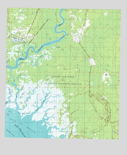
East Pass, FL USGS Topographic Map
Click on map above to begin viewing in our Map Viewer.

This topographic map contains these locations and features:
Feature Name Type Latitude Longitude GNIS ID View Map
Barnett CreekStreamN29.2700°W83.0987°278118View Map
Beech Creek (historical)Populated PlaceN29.3336°W83.0498°294561View Map
Big Trout CreekStreamN29.2672°W83.0832°278765View Map
Bull CreekStreamN29.2916°W83.1118°279638View Map
Dan May CreekStreamN29.2777°W83.1104°281273View Map
Dead Boy CreekStreamN29.3211°W83.1112°281375View Map
Dixie County Fire and Rescue Station 71BuildingN29.3473°W83.1247°2644351View Map
East PassChannelN29.3008°W83.1146°282009View Map
Flag CreekStreamN29.3436°W83.0762°282535View Map
Fletcher LandingLocaleN29.3508°W83.0587°295284View Map
Gopher RiverStreamN29.3277°W83.1018°283215View Map
Little Trout CreekStreamN29.2580°W83.0771°285843View Map
McCormick CreekStreamN29.2872°W83.0823°286585View Map
Monden CreekStreamN29.3308°W83.1032°287057View Map
Pitt CreekStreamN29.3058°W83.1148°289000View Map
Raulerson CreekStreamN29.2851°W83.1208°287007View Map
Ridgeway CreekStreamN29.3222°W83.1246°289693View Map
Sand CreekStreamN29.2969°W83.1098°290517View Map
Sandfly CreekStreamN29.3394°W83.0771°290598View Map
Shingle CreekStreamN29.3275°W83.1085°291053View Map
Tiger IslandIslandN29.3111°W83.0160°292280View Map
Turkey CreekStreamN29.3594°W83.0701°292519View Map
Turkey IslandIslandN29.3744°W83.0629°292532View Map
U-Lee BendBendN29.3316°W83.0918°303897View Map
Weeks Fisher CreekStreamN29.2705°W83.1073°292988View Map
Wisher CreekStreamN29.3363°W83.0937°293438View Map

Note: Coordinates in the location and feature list above are referenced to NAD83 datum.


Copyright (C) 2008-2025 Ryan Niemi / Sunset Dynamics ... All Rights Reserved