TopoQuest Logo
Do you find TopoQuest useful?
Help keep TopoQuest running and adding new maps/features by donating!
Bitcoin:  19c7KJd3qBynnjoSw5npx9KScwjBe4ifkT
Litecoin:  LXs6TkuXGGXo1vDsWCkWVdjQX94eUKd6ui
Home View Maps Find Maps Find Places Resources & Links


Cedar Key, Florida Topographic Map

USGS Map Title: Cedar Key, FL
USGS Map MRC: 29083B1
DRG (GeoTIFF) Download: o29083b1.tif


Neighboring USGS Topographic Map Quads:


  Suwannee, FL  
29083C2
 

  East Pass, FL  
29083C1
 

  Chiefland SW, FL  
29082C8


  Cedar Key, FL  
29083B1
 

  Sumner, FL  
29082B8


  Seahorse Key, FL  
29083A1


Map MRC Location:

N30°
W84°
N30°
W83°
H8 H7 H6 H5 H4 H3 H2 H1
G8 G7 G6 G5 G4 G3 G2 G1
F8 F7 F6 F5 F4 F3 F2 F1
E8 E7 E6 E5 E4 E3 E2 E1
D8 D7 D6 D5 D4 D3 D2 D1
C8 C7 C6 C5 C4 C3 C2 C1
B8 B7 B6 B5 B4 B3 B2 B1
A8 A7 A6 A5 A4 A3 A2 A1
N29°
W84°
N29°
W83°

Cedar Key, FL USGS 1:24K Topographic Map Preview:
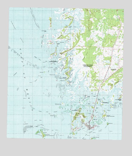
Cedar Key, FL USGS Topographic Map
Click on map above to begin viewing in our Map Viewer.

This topographic map contains these locations and features:
Feature Name Type Latitude Longitude GNIS ID View Map
Black PointCapeN29.1808°W83.0632°278925View Map
Black Point SwampSwampN29.2105°W83.0368°278929View Map
Buck IslandIslandN29.2161°W83.0793°279566View Map
Candy IslandIslandN29.1661°W83.0390°279968View Map
Cedar KeyParkN29.1486°W83.0185°304927View Map
Cedar KeyPopulated PlaceN29.1386°W83.0351°280208View Map
Cedar Key Museum State ParkParkN29.1530°W83.0471°304928View Map
Cedar Key Police DepartmentBuildingN29.1364°W83.0320°2333168View Map
Cedar Key Post OfficePost OfficeN29.1362°W83.0326°2768135View Map
Cedar Key SchoolSchoolN29.1398°W83.0387°298410View Map
Cedar Key Scrub State ReserveParkN29.1891°W83.0346°304926View Map
Cedar Key State MemorialParkN29.1461°W83.0526°299066View Map
Cedar Key State MuseumBuildingN29.1461°W83.0526°1853492View Map
Cedar Key Volunteer Fire DepartmentBuildingN29.1361°W83.0318°2644294View Map
Cedar KeysIslandN29.1580°W83.0465°280209View Map
Cedar PointCapeN29.1591°W83.0093°280216View Map
City of Cedar KeyCivilN29.1452°W83.0385°2404014View Map
Clark CreekStreamN29.2341°W83.0640°280495View Map
Clark IslandIslandN29.2416°W83.0612°304969View Map
Daughtry BayouBayN29.1351°W83.0428°293980View Map
Deer IslandIslandN29.2358°W83.0790°281441View Map
Dennis CreekStreamN29.1969°W83.0685°281503View Map
Derrick KeyIslandN29.1886°W83.0851°281510View Map
Derrick Key GapChannelN29.1847°W83.0854°281511View Map
Dog IslandIslandN29.1405°W83.0154°281653View Map
Ericson CreekStreamN29.2469°W83.0651°282243View Map
Garden IslandIslandN29.2155°W83.0715°282926View Map
George T Lewis AirportAirportN29.1356°W83.0487°304909View Map
Giger CreekStreamN29.2439°W83.0696°283068View Map
Gomez KeysIslandN29.1472°W83.0715°294020View Map
Goose CreekStreamN29.1747°W83.0540°283190View Map
Gulf HammockIslandN29.1789°W83.0082°283491View Map
Havens IslandIslandN29.1611°W83.0271°283818View Map
Hodgson HillSummitN29.1461°W83.0515°284069View Map
Hog IslandIslandN29.2069°W83.0746°284085View Map
Horse IslandIslandN29.2175°W83.0626°284279View Map
Horse Island CreekStreamN29.2250°W83.0521°294415View Map
Levy County Emergency Medical Services Station 5BuildingN29.1829°W83.0191°2661724View Map
Live Oak KeyIslandN29.1669°W83.0007°285873View Map
Lone Cabbage IslandIslandN29.2277°W83.0835°285937View Map
Lone Cabbage ReefBarN29.2422°W83.0987°285938View Map
Long Cabbage IslandIslandN29.2227°W83.0823°304973View Map
Lukens CreekStreamN29.1747°W83.0435°286207View Map
McClamory KeyIslandN29.1875°W83.0723°294074View Map
McCrary CoveBayN29.1294°W83.0887°286594View Map
North BankBarN29.1419°W83.0912°287777View Map
North KeyIslandN29.1311°W83.0865°287828View Map
Northwest ChannelChannelN29.1397°W83.0951°287889View Map
Number Four ChannelChannelN29.1508°W83.0787°287911View Map
Number Three ChannelChannelN29.1522°W83.0248°287912View Map
Pelican ReefBarN29.1672°W83.0787°288680View Map
Piney PointCapeN29.1266°W83.0535°288957View Map
Preacher HoleBayN29.2315°W83.0571°289293View Map
Prodie CreekStreamN29.1730°W83.0093°289333View Map
Raleigh IslandsIslandN29.2247°W83.0662°289450View Map
Rattlesnake KeyIslandN29.1586°W83.0643°294127View Map
Richards IslandIslandN29.1875°W83.0610°289675View Map
Rye KeyIslandN29.1544°W83.0454°290096View Map
Sand CreekStreamN29.1811°W83.0610°290512View Map
Scale KeyIslandN29.1483°W83.0190°290737View Map
Seabreeze CreekStreamN29.1869°W83.0657°290786View Map
Seabreeze IslandIslandN29.1972°W83.0607°290787View Map
Shell MoundSummitN29.2069°W83.0673°290987View Map
South BankBarN29.1369°W83.0957°291335View Map
Spanish Bayonet IslandIslandN29.1958°W83.0793°298051View Map
Steamboat GapChannelN29.1916°W83.1104°291660View Map
Sunset PointCapeN29.1552°W83.0287°291879View Map
Suwannee ReefBarN29.2011°W83.1079°291911View Map
Wakasassa (historical)Populated PlaceN29.2002°W83.0165°294529View Map
Way KeyIslandN29.1491°W83.0446°292955View Map
White Shell BarBarN29.2141°W83.1246°293901View Map

Note: Coordinates in the location and feature list above are referenced to NAD83 datum.


Copyright (C) 2008-2025 Ryan Niemi / Sunset Dynamics ... All Rights Reserved