TopoQuest Logo
Do you find TopoQuest useful?
Help keep TopoQuest running and adding new maps/features by donating!
Bitcoin:  19c7KJd3qBynnjoSw5npx9KScwjBe4ifkT
Litecoin:  LXs6TkuXGGXo1vDsWCkWVdjQX94eUKd6ui
Home View Maps Find Maps Find Places Resources & Links


Swift Run Gap, Virginia Topographic Map

USGS Map Title: Swift Run Gap, VA
USGS Map MRC: 38078C5
DRG (GeoTIFF) Download: o38078c5.tif


Neighboring USGS Topographic Map Quads:


  Elkton West, VA  
38078D6
 

  Elkton East, VA  
38078D5
 

  Fletcher, VA  
38078D4
 

  McGaheysville, VA  
38078C6
 

  Swift Run Gap, VA  
38078C5
 

  Stanardsville, VA  
38078C4
 

  Browns Cove, VA  
38078B6
 

  Free Union, VA  
38078B5
 

  Earlysville, VA  
38078B4


Map MRC Location:

N39°
W79°
N39°
W78°
H8 H7 H6 H5 H4 H3 H2 H1
G8 G7 G6 G5 G4 G3 G2 G1
F8 F7 F6 F5 F4 F3 F2 F1
E8 E7 E6 E5 E4 E3 E2 E1
D8 D7 D6 D5 D4 D3 D2 D1
C8 C7 C6 C5 C4 C3 C2 C1
B8 B7 B6 B5 B4 B3 B2 B1
A8 A7 A6 A5 A4 A3 A2 A1
N38°
W79°
N38°
W78°

Swift Run Gap, VA USGS 1:24K Topographic Map Preview:
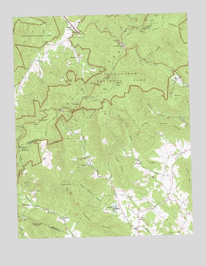
Swift Run Gap, VA USGS Topographic Map
Click on map above to begin viewing in our Map Viewer.

This topographic map contains these locations and features:
Feature Name Type Latitude Longitude GNIS ID View Map
Bacon HollowLocaleN38.2915°W78.5717°1462664View Map
Bacon HollowValleyN38.2819°W78.5580°1462665View Map
Bacon Hollow OverlookLocaleN38.3215°W78.5817°1462666View Map
Beazley (historical)Populated PlaceN38.2965°W78.5067°1706326View Map
Beazley Mill (historical)LocaleN38.3132°W78.5067°1706325View Map
Beazley Post Office (historical)Post OfficeN38.3132°W78.5067°1706327View Map
BeldorPopulated PlaceN38.3501°W78.6072°1499110View Map
Beldor ChurchChurchN38.3457°W78.6139°1463018View Map
Beldor Hollow OverlookLocaleN38.3126°W78.6197°1463019View Map
Beldor Ridge TrailTrailN38.3687°W78.6086°1463020View Map
Big Bend School (historical)SchoolN38.3524°W78.5258°1706328View Map
Blue Ridge LakeReservoirN38.2673°W78.5550°1489923View Map
Blue Ridge SchoolSchoolN38.2649°W78.5551°1475561View Map
Blue Ridge School DamDamN38.2668°W78.5547°1489922View Map
Brokenback MountainSummitN38.2540°W78.5595°1499164View Map
Bryson HollowValleyN38.2726°W78.5673°1463966View Map
Bush MountainSummitN38.3377°W78.5848°1464160View Map
Cedarmere (historical)Populated PlaceN38.2524°W78.5831°1706335View Map
Cedarmere Post Office (historical)Post OfficeN38.2524°W78.5831°1706336View Map
Chesley CreekStreamN38.2596°W78.5461°1464798View Map
Christian CemeteryCemeteryN38.2735°W78.5461°1464889View Map
Cotta Hospital (historical)HospitalN38.3376°W78.5108°1706339View Map
County Line MountainSummitN38.2571°W78.6125°1465313View Map
Daniels MountainSummitN38.3119°W78.5135°1465595View Map
Deep HollowValleyN38.3161°W78.5746°1465706View Map
Dunns Mill (historical)LocaleN38.3446°W78.5150°1706344View Map
DykePopulated PlaceN38.2537°W78.5397°1499366View Map
Dyke Post OfficePost OfficeN38.2536°W78.5397°2766194View Map
Dyke Post Office (historical)Post OfficeN38.2515°W78.5400°1706346View Map
Dyke SchoolSchoolN38.2604°W78.5367°1466076View Map
Dyke Volunteer Fire Company Station 3BuildingN38.2612°W78.5381°2075392View Map
Eaton HollowValleyN38.3490°W78.6072°1466129View Map
Eaton Hollow OverlookLocaleN38.3221°W78.6036°1466130View Map
Evergreen ChurchChurchN38.2718°W78.5447°1466369View Map
FernhillLocaleN38.3571°W78.5442°1477049View Map
Fernhill Post Office (historical)Post OfficeN38.3571°W78.5442°1706352View Map
Flatgut RunStreamN38.3046°W78.5767°1466668View Map
Flattop MountainSummitN38.2944°W78.6047°1499423View Map
Fork HollowValleyN38.2763°W78.6238°1466777View Map
Geer School (historical)SchoolN38.2962°W78.5081°1707460View Map
Gibson ChapelChurchN38.2668°W78.5564°1467067View Map
Goose PondLakeN38.3286°W78.5111°1467260View Map
Gum Spring BranchStreamN38.3432°W78.5078°1706355View Map
HaneytownPopulated PlaceN38.2904°W78.5353°1499520View Map
Haneytown CreekStreamN38.2768°W78.5108°1467705View Map
Hensley Hollow OverlookLocaleN38.3676°W78.5361°1467942View Map
Hensley RidgeRidgeN38.3739°W78.5506°1467944View Map
HightopSummitN38.3364°W78.5514°1468037View Map
Hightop School (historical)SchoolN38.3201°W78.5589°1706360View Map
Hightop ShelterLocaleN38.3332°W78.5578°1468039View Map
Hunt MountainSummitN38.2904°W78.5277°1499586View Map
Industrial School (historical)SchoolN38.2868°W78.5186°1706361View Map
Ivy CreekStreamN38.2679°W78.6111°1468553View Map
Jewel ChapelChurchN38.3376°W78.5108°1706362View Map
Little MountainSummitN38.2829°W78.5256°1469603View Map
Lydia ChurchChurchN38.3376°W78.5083°1469943View Map
Lydia Mennonite ChurchChurchN38.3376°W78.5089°1706368View Map
March (historical)LocaleN38.2654°W78.5289°1706370View Map
March Post Office (historical)Post OfficeN38.2654°W78.5289°1706371View Map
Mission HomeLocaleN38.2679°W78.6206°1470632View Map
Mission Home CemeteryCemeteryN38.2615°W78.6206°1470633View Map
Monroe DistrictCivilN38.2654°W78.5174°1927409View Map
Mount Olivet ChurchChurchN38.2599°W78.5372°1471008View Map
Mountain Grove ChapelChurchN38.2949°W78.5742°1471169View Map
Mutton HollowValleyN38.3154°W78.5059°1471292View Map
Nimrod (historical)LocaleN38.2821°W78.5581°1706375View Map
Nimrod Post Office (historical)Post OfficeN38.2821°W78.5581°1706376View Map
Parker MountainSummitN38.2860°W78.5004°1472062View Map
Parrotts FordCrossingN38.2626°W78.5036°1706383View Map
PirkeyPopulated PlaceN38.2737°W78.5542°1706378View Map
Pirkey Post Office (historical)Post OfficeN38.2737°W78.5542°1706379View Map
Powell GapGapN38.3212°W78.5920°1472736View Map
Powell Gap HollowValleyN38.3085°W78.5778°1472737View Map
Rocky Mount OverlookLocaleN38.3168°W78.6058°1473471View Map
RoundtopSummitN38.3260°W78.5809°1473597View Map
Saddleback MountainSummitN38.3651°W78.5036°1473684View Map
Saddleback Mountain TrailTrailN38.3696°W78.5167°1473685View Map
Saint GeorgePopulated PlaceN38.2679°W78.5525°1707467View Map
Saint George Post Office (historical)Post OfficeN38.2640°W78.5450°1706392View Map
Saint James MissionLocaleN38.3376°W78.5108°1706393View Map
Sandy BottomPopulated PlaceN38.3510°W78.5772°1500024View Map
Sandy Bottom OverlookLocaleN38.3362°W78.5650°1474007View Map
School Number 4 (historical)SchoolN38.2637°W78.5997°1706395View Map
Shady GrovePopulated PlaceN38.2604°W78.5925°1500059View Map
Shiffett HollowValleyN38.2618°W78.5925°1706394View Map
Simmons GapPopulated PlaceN38.2968°W78.6220°1477056View Map
Simmons GapGapN38.3021°W78.6225°1474608View Map
Simmons Gap Mission (historical)LocaleN38.2990°W78.6225°1706396View Map
Simmons Gap Post Office (historical)Post OfficeN38.2968°W78.6220°1706397View Map
Simmons Gap Ranger StationLocaleN38.3001°W78.6206°1474609View Map
Slaters MountainSummitN38.2962°W78.5563°1500120View Map
Smith Roach GapGapN38.3287°W78.5745°1474775View Map
Snow MountainRidgeN38.3118°W78.5354°1474814View Map
South River ShelterLocaleN38.3748°W78.5214°1474895View Map
Sullivan (historical)Populated PlaceN38.2751°W78.6117°1706399View Map
Sullivan Post Office (historical)Post OfficeN38.2751°W78.6117°1706400View Map
Swift RunPopulated PlaceN38.3685°W78.5808°1500201View Map
Swift Run GapGapN38.3571°W78.5450°1475392View Map
Swift Run OverlookLocaleN38.3404°W78.5583°1475393View Map
Temple Hill CemeteryCemeteryN38.3340°W78.5006°1707473View Map
Temple Hill ChurchChurchN38.3340°W78.5006°1475536View Map
Temple Hill Methodist Episcopal Church (historical)ChurchN38.3337°W78.5003°1706402View Map
Victory SchoolSchoolN38.2940°W78.5770°1706406View Map
Waterfall HollowValleyN38.3160°W78.5749°1476371View Map
White Oak Spring BranchStreamN38.3007°W78.5422°1476622View Map
Williams ForkPopulated PlaceN38.2701°W78.5164°1706411View Map
Willis HollowValleyN38.3127°W78.5776°1476782View Map
Wyatt MountainSummitN38.2765°W78.5867°1474312View Map
Wyatt Mountain ChurchChurchN38.2801°W78.5878°1474313View Map
Yellow BranchStreamN38.2818°W78.5578°1474335View Map

Note: Coordinates in the location and feature list above are referenced to NAD83 datum.


Copyright (C) 2008-2025 Ryan Niemi / Sunset Dynamics ... All Rights Reserved