TopoQuest Logo
Do you find TopoQuest useful?
Help keep TopoQuest running and adding new maps/features by donating!
Bitcoin:  19c7KJd3qBynnjoSw5npx9KScwjBe4ifkT
Litecoin:  LXs6TkuXGGXo1vDsWCkWVdjQX94eUKd6ui
Home View Maps Find Maps Find Places Resources & Links


Elkton West, Virginia Topographic Map

USGS Map Title: Elkton West, VA
USGS Map MRC: 38078D6
DRG (GeoTIFF) Download: o38078d6.tif


Neighboring USGS Topographic Map Quads:


  Broadway, VA  
38078E7
 

  Tenth Legion, VA  
38078E6
 

  Stanley, VA  
38078E5
 

  Harrisonburg, VA  
38078D7
 

  Elkton West, VA  
38078D6
 

  Elkton East, VA  
38078D5
 

  Grottoes, VA  
38078C7
 

  McGaheysville, VA  
38078C6
 

  Swift Run Gap, VA  
38078C5


Map MRC Location:

N39°
W79°
N39°
W78°
H8 H7 H6 H5 H4 H3 H2 H1
G8 G7 G6 G5 G4 G3 G2 G1
F8 F7 F6 F5 F4 F3 F2 F1
E8 E7 E6 E5 E4 E3 E2 E1
D8 D7 D6 D5 D4 D3 D2 D1
C8 C7 C6 C5 C4 C3 C2 C1
B8 B7 B6 B5 B4 B3 B2 B1
A8 A7 A6 A5 A4 A3 A2 A1
N38°
W79°
N38°
W78°

Elkton West, VA USGS 1:24K Topographic Map Preview:
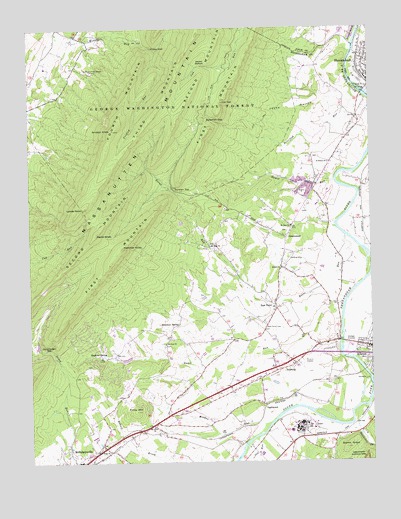
Elkton West, VA USGS Topographic Map
Click on map above to begin viewing in our Map Viewer.

This topographic map contains these locations and features:
Feature Name Type Latitude Longitude GNIS ID View Map
Bethel ChurchChurchN38.4307°W78.6572°1481667View Map
Bloomer SpringPopulated PlaceN38.4146°W78.6972°1494184View Map
Boone RunStreamN38.4398°W78.6342°1481934View Map
Boone Run ShelterLocaleN38.4615°W78.7053°1488520View Map
Brethren of the Woods CampLocaleN38.4873°W78.7259°1481979View Map
East PointPopulated PlaceN38.4193°W78.6597°1483217View Map
East Point CemeteryCemeteryN38.4137°W78.6636°1483218View Map
Elk RunStreamN38.4054°W78.6325°1483282View Map
Elkton Airport (historical)AirportN38.4335°W78.6553°1498660View Map
Elkton Volunteer Fire CompanyBuildingN38.4021°W78.6624°2086018View Map
First MountainSummitN38.4340°W78.7195°1494220View Map
First MountainSummitN38.4369°W78.7156°1499413View Map
Fourth MountainSummitN38.4710°W78.7184°1494223View Map
Fridley GapGapN38.4943°W78.7028°1483543View Map
Fridley RunStreamN38.4937°W78.7020°1483544View Map
Gap RunStreamN38.3823°W78.6664°1483585View Map
Giants GraveSummitN38.3792°W78.6341°1483612View Map
Golden Valley DairyLocaleN38.3925°W78.6417°2676001View Map
GreenwoodPopulated PlaceN38.4393°W78.6556°1494228View Map
Grubbs KnobSummitN38.4704°W78.7180°1494229View Map
Harshberger GapGapN38.4076°W78.7425°1483959View Map
Hartman KnobSummitN38.4369°W78.7156°1483961View Map
Hawksbill CreekStreamN38.3868°W78.6317°1483978View Map
Hopkins SpringPopulated PlaceN38.4076°W78.7259°1494234View Map
Humes RunStreamN38.4560°W78.6378°1484273View Map
InglewoodPopulated PlaceN38.3904°W78.6647°1494237View Map
Jayho HollowValleyN38.4787°W78.6423°1484403View Map
Kaylor KnobSummitN38.4415°W78.7250°1494240View Map
Lairds KnobSummitN38.4482°W78.7303°1484644View Map
Little GapGapN38.4787°W78.6789°1484910View Map
Martin BottomBendN38.4893°W78.6856°1485203View Map
MassanuttenPopulated PlaceN38.4096°W78.7378°1867594View Map
Massanutten Census Designated PlaceCensusN38.4115°W78.7270°2390129View Map
Massanutten Police DepartmentBuildingN38.4057°W78.7193°2766987View Map
McGaheysville Volunteer Fire DepartmentBuildingN38.3767°W78.7291°2086024View Map
Monger RunStreamN38.3857°W78.6628°1485516View Map
Mount Olivet ChurchChurchN38.3854°W78.7053°1485623View Map
Mount Sinai ChurchChurchN38.4373°W78.6836°1485641View Map
Mount Zion ChurchChurchN38.4090°W78.7006°1485668View Map
Mount Zion ChurchChurchN38.4429°W78.6536°1485669View Map
New Hope Baptist ChurchChurchN38.3782°W78.7214°1485848View Map
Peterfish GapGapN38.4732°W78.6811°1486158View Map
Peterfish RunStreamN38.4843°W78.6314°1486159View Map
Piney MountainSummitN38.3896°W78.7114°1486254View Map
Quail RunStreamN38.4268°W78.6375°1486461View Map
Runkles GapGapN38.4532°W78.6961°1486816View Map
Saint Peters ChurchChurchN38.4612°W78.6400°1486885View Map
Second MountainSummitN38.4410°W78.7252°1494264View Map
ShenandoahPopulated PlaceN38.4851°W78.6250°1494269View Map
Shenandoah DamDamN38.4801°W78.6264°1490538View Map
Shenandoah ReservoirReservoirN38.4801°W78.6264°1490539View Map
Shuler IslandIslandN38.4982°W78.6297°1487232View Map
Snag RunStreamN38.4198°W78.6603°1779343View Map
SolsburgPopulated PlaceN38.4032°W78.6531°1494274View Map

Note: Coordinates in the location and feature list above are referenced to NAD83 datum.


Copyright (C) 2008-2025 Ryan Niemi / Sunset Dynamics ... All Rights Reserved