TopoQuest Logo
Do you find TopoQuest useful?
Help keep TopoQuest running and adding new maps/features by donating!
Bitcoin:  19c7KJd3qBynnjoSw5npx9KScwjBe4ifkT
Litecoin:  LXs6TkuXGGXo1vDsWCkWVdjQX94eUKd6ui
Home View Maps Find Maps Find Places Resources & Links


Sycamore Flat, California Topographic Map

USGS Map Title: Sycamore Flat, CA
USGS Map MRC: 36121C4
DRG (GeoTIFF) Download: o36121c4.tif


Neighboring USGS Topographic Map Quads:


  Rana Creek, CA  
36121D5
 

  Palo Escrito Peak, CA  
36121D4
 

  Soledad, CA  
36121D3
 

  Chews Ridge, CA  
36121C5
 

  Sycamore Flat, CA  
36121C4
 

  Paraiso Springs, CA  
36121C3
 

  Zigzag Creek, CA  
36121B5
 

  Junipero Serra Peak, CA  
36121B4
 

  Reliz Canyon, CA  
36121B3


Map MRC Location:

N37°
W122°
N37°
W121°
H8 H7 H6 H5 H4 H3 H2 H1
G8 G7 G6 G5 G4 G3 G2 G1
F8 F7 F6 F5 F4 F3 F2 F1
E8 E7 E6 E5 E4 E3 E2 E1
D8 D7 D6 D5 D4 D3 D2 D1
C8 C7 C6 C5 C4 C3 C2 C1
B8 B7 B6 B5 B4 B3 B2 B1
A8 A7 A6 A5 A4 A3 A2 A1
N36°
W122°
N36°
W121°

Sycamore Flat, CA USGS 1:24K Topographic Map Preview:
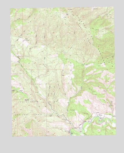
Sycamore Flat, CA USGS Topographic Map
Click on map above to begin viewing in our Map Viewer.

This topographic map contains these locations and features:
Feature Name Type Latitude Longitude GNIS ID View Map
Basin CreekStreamN36.2836°W121.4308°239029View Map
Big Sand CreekStreamN36.3252°W121.4894°239305View Map
Calaboose CreekStreamN36.2955°W121.4949°239996View Map
Corral CanyonValleyN36.2858°W121.4591°240938View Map
Ell PeakSummitN36.3650°W121.4344°1660613View Map
Fritch RanchLocaleN36.3433°W121.4849°242516View Map
George RanchLocaleN36.3739°W121.4008°242679View Map
Grandmas FlatFlatN36.2614°W121.3874°242899View Map
Hermits CabinLocaleN36.3272°W121.3772°243379View Map
Hicks RanchLocaleN36.3686°W121.4330°243408View Map
Horse CanyonValleyN36.2511°W121.4141°243649View Map
Horse CreekStreamN36.2527°W121.4160°243651View Map
Little Sand CreekStreamN36.3364°W121.4991°244950View Map
Long CanyonValleyN36.2755°W121.4513°245062View Map
Lower Piney Creek CampgroundLocaleN36.2766°W121.4680°275490View Map
Millers RanchPopulated PlaceN36.2519°W121.4299°1661029View Map
Paloma CreekStreamN36.2730°W121.4499°247187View Map
Paloma Creek School (historical)SchoolN36.3280°W121.4930°1873446View Map
Paloma RidgeRidgeN36.3594°W121.4160°247190View Map
Piney CreekStreamN36.2519°W121.4188°247526View Map
Piney Creek CampgroundLocaleN36.2864°W121.4799°247527View Map
Piney Creek CampgroundLocaleN36.2825°W121.4708°275489View Map
Purd CampLocaleN36.3519°W121.3988°247829View Map
Rio Alto Gun ClubLocaleN36.2711°W121.4524°248207View Map
Sand CreekStreamN36.2633°W121.4313°248990View Map
Soledad DivisionCivilN36.3692°W121.4216°1935311View Map
Sycamore FlatPopulated PlaceN36.2666°W121.3935°1661537View Map
Tash CreekStreamN36.3011°W121.4749°250265View Map
The BasinBasinN36.3186°W121.4124°250365View Map
The Dry LakeLakeN36.2742°W121.4247°250374View Map
Twin PeaksSummitN36.3716°W121.4269°250747View Map

Note: Coordinates in the location and feature list above are referenced to NAD83 datum.


Copyright (C) 2008-2025 Ryan Niemi / Sunset Dynamics ... All Rights Reserved