TopoQuest Logo
Do you find TopoQuest useful?
Help keep TopoQuest running and adding new maps/features by donating!
Bitcoin:  19c7KJd3qBynnjoSw5npx9KScwjBe4ifkT
Litecoin:  LXs6TkuXGGXo1vDsWCkWVdjQX94eUKd6ui
Home View Maps Find Maps Find Places Resources & Links


Tar Heel, North Carolina Topographic Map

USGS Map Title: Tar Heel, NC
USGS Map MRC: 34078F7
DRG (GeoTIFF) Download: o34078f7.tif


Neighboring USGS Topographic Map Quads:


  Saint Pauls, NC  
34078G8
 

  Duart, NC  
34078G7
 

  Jerome, NC  
34078G6
 

  Northeast Lumberton, NC  
34078F8
 

  Tar Heel, NC  
34078F7
 

  Dublin, NC  
34078F6
 

  Southeast Lumberton, NC  
34078E8
 

  Bladenboro, NC  
34078E7
 

  Abbottsburg, NC  
34078E6


Map MRC Location:

N35°
W79°
N35°
W78°
H8 H7 H6 H5 H4 H3 H2 H1
G8 G7 G6 G5 G4 G3 G2 G1
F8 F7 F6 F5 F4 F3 F2 F1
E8 E7 E6 E5 E4 E3 E2 E1
D8 D7 D6 D5 D4 D3 D2 D1
C8 C7 C6 C5 C4 C3 C2 C1
B8 B7 B6 B5 B4 B3 B2 B1
A8 A7 A6 A5 A4 A3 A2 A1
N34°
W79°
N34°
W78°

Tar Heel, NC USGS 1:24K Topographic Map Preview:
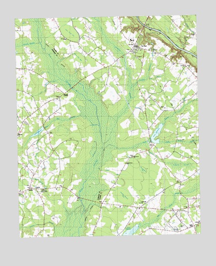
Tar Heel, NC USGS Topographic Map
Click on map above to begin viewing in our Map Viewer.

This topographic map contains these locations and features:
Feature Name Type Latitude Longitude GNIS ID View Map
ABE Branch ChurchChurchN34.6699°W78.7956°1026236View Map
Allen CemeteryCemeteryN34.6554°W78.7639°980099View Map
Allen CemeteryCemeteryN34.6691°W78.7564°1026235View Map
Allen Pocket CanalCanalN34.6602°W78.8056°980113View Map
Beth Car ChurchChurchN34.7313°W78.7814°981060View Map
Bethel Light ChurchChurchN34.6432°W78.7897°1007495View Map
Black SwampStreamN34.6724°W78.8167°981544View Map
Black Swamp ChurchChurchN34.6663°W78.7997°981547View Map
Bryan CemeteryCemeteryN34.6757°W78.7825°1007494View Map
Bryan MillpondReservoirN34.6798°W78.7829°998106View Map
Bryan Millpond DamDamN34.6802°W78.7831°998107View Map
Buck BranchStreamN34.7460°W78.8197°1025192View Map
Burney CemeteryCemeteryN34.6977°W78.7756°1007493View Map
Buzzard BaySwampN34.6607°W78.8678°982349View Map
Byrd CemeteryCemeteryN34.6263°W78.8561°982366View Map
Calvary ChurchChurchN34.7057°W78.8459°982439View Map
Center RoadPopulated PlaceN34.6299°W78.7542°1005914View Map
Center Road ChurchChurchN34.6318°W78.7509°982942View Map
Clark ChapelChurchN34.7341°W78.7936°983214View Map
Crooked Bay BranchStreamN34.7102°W78.7950°983761View Map
Davis CemeteryCemeteryN34.7040°W78.8464°983990View Map
Double BranchStreamN34.6821°W78.8606°984278View Map
Double Branch BaySwampN34.6493°W78.8039°984281View Map
East Robeson Lookout TowerTowerN34.6527°W78.8597°1023638View Map
Fishpond BranchStreamN34.6743°W78.7847°985122View Map
Fishpond SwampSwampN34.6638°W78.7675°985123View Map
Freewill ChurchChurchN34.7274°W78.7922°985398View Map
Goodman SwampStreamN34.6777°W78.8159°1025335View Map
Grimes CemeteryCemeteryN34.7213°W78.7542°1007492View Map
Gum Flat BaySwampN34.7274°W78.8331°986215View Map
Hester MillpondReservoirN34.6266°W78.7986°1025869View Map
Huckleberry SwampGutN34.7252°W78.7803°1025408View Map
Hursey CemeteryCemeteryN34.6703°W78.7952°987286View Map
Lewis Mill BranchStreamN34.7152°W78.8450°1025471View Map
Love Grove ChurchChurchN34.7324°W78.7909°1007491View Map
Mayville CrossingPopulated PlaceN34.7071°W78.8425°989510View Map
Mill SwampStreamN34.6374°W78.8406°1025542View Map
New Pait CemeteryCemeteryN34.6279°W78.7653°1007497View Map
Oakdale ChurchChurchN34.7493°W78.7684°991459View Map
Old Pait CemeteryCemeteryN34.6296°W78.7642°1007496View Map
Penderdam BaySwampN34.6629°W78.7884°992016View Map
Phillips CreekStreamN34.7310°W78.7595°992144View Map
Plain View SchoolSchoolN34.7379°W78.8409°992447View Map
Reedy Meadow SwampStreamN34.6779°W78.7772°1025645View Map
Rocking A Farm AirportAirportN34.7370°W78.7503°2679281View Map
Shady Grove ChurchChurchN34.7293°W78.8267°994539View Map
Sims Pond BaySwampN34.7421°W78.8364°994856View Map
SmithsPopulated PlaceN34.6529°W78.8675°994998View Map
Smiths BridgeBridgeN34.6474°W78.8328°994999View Map
Smiths MillpondReservoirN34.6852°W78.8603°995009View Map
Tar HeelPopulated PlaceN34.7332°W78.7900°995863View Map
Tar Heel ChurchChurchN34.7271°W78.7914°1007490View Map
Tar Heel LandingLocaleN34.7449°W78.7867°1022887View Map
Tar Heel Post OfficePost OfficeN34.7332°W78.7900°2774366View Map
Tar Heel Rural Volunteer Fire DepartmentBuildingN34.7377°W78.7907°2639162View Map
Tar Heel Volunteer Rescue SquadBuildingN34.7353°W78.7953°2720452View Map
Tenmile SwampStreamN34.7363°W78.8589°1025744View Map
Town of Tar HeelCivilN34.7331°W78.7903°2406713View Map
Township of East HowellsvilleCivilN34.6771°W78.8674°1027105View Map
White Oak SwampStreamN34.6882°W78.8186°1025790View Map
Wilson CemeteryCemeteryN34.7024°W78.8445°997435View Map
Zion Hill ChurchChurchN34.6535°W78.8628°1007498View Map
Zion TabernacleChurchN34.6838°W78.8745°1025816View Map

Note: Coordinates in the location and feature list above are referenced to NAD83 datum.


Copyright (C) 2008-2024 Ryan Niemi / Sunset Dynamics ... All Rights Reserved