TopoQuest Logo
Do you find TopoQuest useful?
Help keep TopoQuest running and adding new maps/features by donating!
Bitcoin:  19c7KJd3qBynnjoSw5npx9KScwjBe4ifkT
Litecoin:  LXs6TkuXGGXo1vDsWCkWVdjQX94eUKd6ui
Home View Maps Find Maps Find Places Resources & Links


Morrow, Louisiana Topographic Map

USGS Map Title: Morrow, LA
USGS Map MRC: 30092G1
DRG (GeoTIFF) Download: o30092g1.tif


Neighboring USGS Topographic Map Quads:


  Bunkie, LA  
30092H2
 

  Cottonport, LA  
30092H1
 

  Plaucheville, LA  
30091H8
 

  Whiteville, LA  
30092G2
 

  Morrow, LA  
30092G1
 

  Bayou Jack, LA  
30091G8
 

  Tate Cove, LA  
30092F2
 

  Beggs, LA  
30092F1
 

  Palmetto, LA  
30091F8


Map MRC Location:

N31°
W93°
N31°
W92°
H8 H7 H6 H5 H4 H3 H2 H1
G8 G7 G6 G5 G4 G3 G2 G1
F8 F7 F6 F5 F4 F3 F2 F1
E8 E7 E6 E5 E4 E3 E2 E1
D8 D7 D6 D5 D4 D3 D2 D1
C8 C7 C6 C5 C4 C3 C2 C1
B8 B7 B6 B5 B4 B3 B2 B1
A8 A7 A6 A5 A4 A3 A2 A1
N30°
W93°
N30°
W92°

Morrow, LA USGS 1:24K Topographic Map Preview:
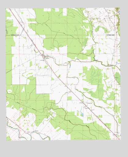
Morrow, LA USGS Topographic Map
Click on map above to begin viewing in our Map Viewer.

This topographic map contains these locations and features:
Feature Name Type Latitude Longitude GNIS ID View Map
Antioch ChurchChurchN30.8657°W92.0112°553306View Map
Big CanePopulated PlaceN30.8205°W92.0096°560174View Map
Big Cane ChurchChurchN30.8096°W92.0060°560175View Map
Big Cane ChurchChurchN30.8246°W92.0262°560176View Map
Big Cane Gas FieldOilfieldN30.8080°W92.0360°552571View Map
BorettaPopulated PlaceN30.7524°W92.1098°552574View Map
Burn School (historical)SchoolN30.8599°W92.1051°549398View Map
Dry BayouStreamN30.8255°W92.0273°560657View Map
DubuissonPopulated PlaceN30.7596°W92.0943°560660View Map
GoudeauPopulated PlaceN30.8719°W92.0143°554560View Map
Goudeau CemeteryCemeteryN30.8732°W92.0112°535296View Map
Goudeau School (historical)SchoolN30.8652°W92.0112°549403View Map
Gum RidgeRidgeN30.8671°W92.0185°535459View Map
Gum Ridge (historical)Populated PlaceN30.8688°W92.0251°545523View Map
Hebert CemeteryCemeteryN30.8238°W92.0557°560950View Map
Le MoyenPopulated PlaceN30.7855°W92.0404°1627460View Map
Le Moyen Post OfficePost OfficeN30.7849°W92.0410°1631984View Map
Lincoln SchoolSchoolN30.8260°W92.0840°1627483View Map
Little Rock ChurchChurchN30.8621°W92.1062°536606View Map
Macedonia ChurchChurchN30.7805°W92.0362°1627587View Map
MorrowPopulated PlaceN30.8299°W92.0801°1627700View Map
Morrow CemeteryCemeteryN30.8655°W92.0243°537239View Map
Morrow Elementary SchoolSchoolN30.8260°W92.0837°552628View Map
Morrow Post OfficePost OfficeN30.8299°W92.0838°1631991View Map
Morrow StripAirportN30.8020°W92.0604°2676755View Map
Prairie Du Bayou RougeFlatN30.8460°W92.0154°552654View Map
Richards SpurLocaleN30.7858°W92.0360°1628051View Map
Robinson CemeteryCemeteryN30.8677°W92.0121°538651View Map
RosaPopulated PlaceN30.7552°W92.0073°1628072View Map
Rosa Post OfficePost OfficeN30.7549°W92.0065°1632003View Map
Rosa School (historical)SchoolN30.7671°W92.0037°552657View Map
Saint Catherines ChurchChurchN30.7569°W92.0032°1628104View Map
Saint James CemeteryCemeteryN30.7785°W92.0326°552666View Map
Saint James ChurchChurchN30.7788°W92.0323°1628119View Map
Saint Josephs ChurchChurchN30.7577°W92.1012°1628131View Map
Saint Landry Parish Fire District Morrow Volunteer Fire StationBuildingN30.7962°W92.0541°2691637View Map
Saint Luke ChurchChurchN30.8096°W92.0504°1628134View Map
Saint Lukes CemeteryCemeteryN30.8091°W92.0496°552675View Map
Saint Marks CemeteryCemeteryN30.7957°W92.0534°552676View Map
Saint Marks ChurchChurchN30.7963°W92.0529°1628137View Map
Saint Peters Catholic ChurchChurchN30.8292°W92.0801°2602755View Map
Snowden CemeteryCemeteryN30.8741°W92.0279°539464View Map
State CanalCanalN30.8577°W92.0771°1958778View Map
Zion Traveler ChurchChurchN30.8655°W92.0326°540608View Map

Note: Coordinates in the location and feature list above are referenced to NAD83 datum.


Copyright (C) 2008-2025 Ryan Niemi / Sunset Dynamics ... All Rights Reserved