TopoQuest Logo
Do you find TopoQuest useful?
Help keep TopoQuest running and adding new maps/features by donating!
Bitcoin:  19c7KJd3qBynnjoSw5npx9KScwjBe4ifkT
Litecoin:  LXs6TkuXGGXo1vDsWCkWVdjQX94eUKd6ui
Home View Maps Find Maps Find Places Resources & Links


Rockmart North, Georgia Topographic Map

USGS Map Title: Rockmart North, GA
USGS Map MRC: 34085A1
DRG (GeoTIFF) Download: o34085a1.tif


Neighboring USGS Topographic Map Quads:


  Rome South, GA  
34085B2
 

  Wax, GA  
34085B1
 

  Kingston, GA  
34084B8
 

  Cedartown East, GA  
34085A2
 

  Rockmart North, GA  
34085A1
 

  Taylorsville, GA  
34084A8
 

  Felton, GA  
33085H2
 

  Rockmart South, GA  
33085H1
 

  Yorkville, GA  
33084H8


Map MRC Location:

N35°
W86°
N35°
W85°
H8 H7 H6 H5 H4 H3 H2 H1
G8 G7 G6 G5 G4 G3 G2 G1
F8 F7 F6 F5 F4 F3 F2 F1
E8 E7 E6 E5 E4 E3 E2 E1
D8 D7 D6 D5 D4 D3 D2 D1
C8 C7 C6 C5 C4 C3 C2 C1
B8 B7 B6 B5 B4 B3 B2 B1
A8 A7 A6 A5 A4 A3 A2 A1
N34°
W86°
N34°
W85°

Rockmart North, GA USGS 1:24K Topographic Map Preview:
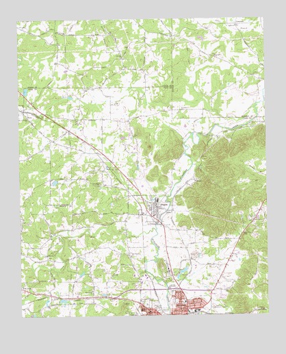
Rockmart North, GA USGS Topographic Map
Click on map above to begin viewing in our Map Viewer.

This topographic map contains these locations and features:
Feature Name Type Latitude Longitude GNIS ID View Map
AragonPopulated PlaceN34.0457°W85.0561°354383View Map
Aragon Baptist ChurchChurchN34.0470°W85.0577°343520View Map
Aragon City Fire DepartmentBuildingN34.0438°W85.0596°2603881View Map
Aragon DivisionCivilN34.0520°W85.0456°1936083View Map
Aragon Police DepartmentBuildingN34.0437°W85.0596°2733506View Map
Aragon StationLocaleN34.0440°W85.0483°343521View Map
Bellview African Methodist Episcopal ChurchChurchN34.0468°W85.1052°311065View Map
Bellview Baptist ChurchChurchN34.0257°W85.1113°354537View Map
Bethel ChurchChurchN34.1218°W85.0144°354638View Map
Bethel ChurchChurchN34.0840°W85.1208°311208View Map
Bethel Crossroads CemeteryCemeteryN34.1230°W85.0150°2358010View Map
Bethlehem Church (historical)ChurchN34.0868°W85.0422°334239View Map
Bethlehem Methodist Church CemeteryCemeteryN34.0868°W85.0427°311228View Map
Brewers (historical)Populated PlaceN34.0084°W85.1097°343527View Map
City of AragonCivilN34.0457°W85.0571°2403105View Map
City of RockmartCivilN34.0103°W85.0442°2404639View Map
CrossroadsPopulated PlaceN34.1226°W85.0141°331483View Map
Crossroads ChurchChurchN34.0748°W85.1058°343540View Map
Culver Chapel CemeteryCemeteryN34.1040°W85.0680°353602View Map
Culvers Chapel (historical)ChurchN34.1040°W85.0683°353603View Map
Davette SpringSpringN34.0729°W85.0416°343542View Map
David ChapelChurchN34.1020°W85.0030°334266View Map
Davis Chapel CemeteryCemeteryN34.1019°W85.0033°2358450View Map
Davitte (historical)Populated PlaceN34.0628°W85.0334°2677682View Map
Deaton MineMineN34.0765°W85.0147°343543View Map
Deaton SpringSpringN34.0754°W85.0294°343544View Map
Dickerson Family CemeteryCemeteryN34.0922°W85.0119°2358549View Map
Eastside Elementary SchoolSchoolN34.0168°W85.0674°2545569View Map
Elm Street SchoolSchoolN34.0026°W85.0641°355680View Map
Euharlee SchoolSchoolN34.0020°W85.0602°355720View Map
Fish CreekStreamN34.0362°W85.0563°355802View Map
Flint Hill CemeteryCemeteryN34.1087°W85.0733°353663View Map
Flint Hill ChurchChurchN34.1084°W85.0719°355847View Map
Flint Hill School (historical)SchoolN34.1193°W85.0577°353664View Map
Goodyear Elementary SchoolSchoolN34.0017°W85.0407°343562View Map
Hamlet (historical)Populated PlaceN34.0687°W85.0861°343565View Map
Harmony School (historical)SchoolN34.1182°W85.1058°353705View Map
Hills Creek ChurchChurchN34.0401°W85.0074°315434View Map
Jones CemeteryCemeteryN34.0759°W85.0672°316218View Map
Jones School (historical)SchoolN34.0820°W85.0780°343572View Map
Live Oak ChurchChurchN34.0815°W85.0958°356367View Map
Morning View ChurchChurchN34.0107°W85.0891°318479View Map
Mount Tabor ChurchChurchN34.1090°W85.0249°318893View Map
Mount Tabor Church CemeteryCemeteryN34.1094°W85.0250°2359249View Map
New Euharlee ChurchChurchN34.0387°W85.0552°319309View Map
New Hope ChurchChurchN34.0782°W85.1011°343579View Map
New Prospect ChurchChurchN34.0251°W85.0691°356424View Map
Oak Ridge ChurchChurchN34.0554°W85.0838°356438View Map
Pepper LakeReservoirN34.0065°W85.1040°337640View Map
Pepper Lake DamDamN34.0068°W85.1049°337639View Map
Piedmont Avenue Baptist ChurchChurchN34.0034°W85.0408°343583View Map
Pine Hill ChurchChurchN34.0884°W85.1227°320605View Map
Pine Hill LakeReservoirN34.0950°W85.1215°339798View Map
Pine Hill Lake DamDamN34.0951°W85.1216°339797View Map
Pineville (historical)BuildingN34.0076°W85.0780°343584View Map
Polk County Fire Department Aragon StationBuildingN34.0440°W85.0638°2603999View Map
Polk Medical CenterHospitalN34.0057°W85.0419°343588View Map
PortlandPopulated PlaceN34.0573°W85.0363°356479View Map
Posco (historical)Populated PlaceN34.0754°W85.0247°343589View Map
Ravenel (historical)Populated PlaceN34.0570°W85.0699°343591View Map
Red Ore (historical)Populated PlaceN34.0282°W85.0408°343592View Map
RockmartPopulated PlaceN34.0026°W85.0416°356502View Map
Rockmart Fire DepartmentBuildingN34.0024°W85.0395°2603959View Map
Rockmart High SchoolSchoolN34.0191°W85.0202°343594View Map
Rockmart Memorial GardensCemeteryN34.0032°W85.0280°321775View Map
Rockmart Middle SchoolSchoolN34.0202°W85.0157°2545602View Map
Rockmart QuarryMineN34.0192°W85.0553°2559503View Map
Rose Hill CemeteryCemeteryN34.0018°W85.0549°321917View Map
Ross CemeteryCemeteryN34.1065°W85.0777°353861View Map
SeneyPopulated PlaceN34.0848°W85.1211°333006View Map
Seney ChurchChurchN34.0843°W85.1211°343599View Map
Shady Grove ChurchChurchN34.0620°W85.0766°322770View Map
West Aragon ChurchChurchN34.0582°W85.0911°343608View Map
WZOT-AM (Rockmart)TowerN34.0040°W85.0561°352527View Map

Note: Coordinates in the location and feature list above are referenced to NAD83 datum.


Copyright (C) 2008-2024 Ryan Niemi / Sunset Dynamics ... All Rights Reserved