TopoQuest Logo
Do you find TopoQuest useful?
Help keep TopoQuest running and adding new maps/features by donating!
Bitcoin:  19c7KJd3qBynnjoSw5npx9KScwjBe4ifkT
Litecoin:  LXs6TkuXGGXo1vDsWCkWVdjQX94eUKd6ui
Home View Maps Find Maps Find Places Resources & Links


Tchula, Mississippi Topographic Map

USGS Map Title: Tchula, MS
USGS Map MRC: 33090B2
DRG (GeoTIFF) Download: o33090b2.tif


Neighboring USGS Topographic Map Quads:


  Montgomery, MS  
33090C3
 

  Cruger, MS  
33090C2
 

  Black Hawk, MS  
33090C1
 

  Marcella, MS  
33090B3
 

  Tchula, MS  
33090B2
 

  Lexington North, MS  
33090B1
 

  Thornton, MS  
33090A3
 

  Howard, MS  
33090A2
 

  Lexington South, MS  
33090A1


Map MRC Location:

N34°
W91°
N34°
W90°
H8 H7 H6 H5 H4 H3 H2 H1
G8 G7 G6 G5 G4 G3 G2 G1
F8 F7 F6 F5 F4 F3 F2 F1
E8 E7 E6 E5 E4 E3 E2 E1
D8 D7 D6 D5 D4 D3 D2 D1
C8 C7 C6 C5 C4 C3 C2 C1
B8 B7 B6 B5 B4 B3 B2 B1
A8 A7 A6 A5 A4 A3 A2 A1
N33°
W91°
N33°
W90°

Tchula, MS USGS 1:24K Topographic Map Preview:
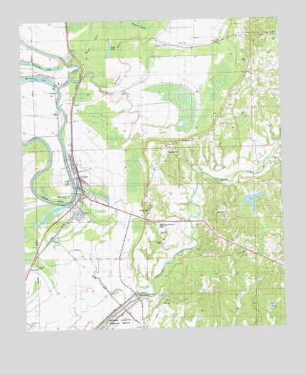
Tchula, MS USGS Topographic Map
Click on map above to begin viewing in our Map Viewer.

This topographic map contains these locations and features:
Feature Name Type Latitude Longitude GNIS ID View Map
Albino CemeteryCemeteryN33.2135°W90.2315°666883View Map
Albino Landing (historical)LocaleN33.2096°W90.2281°706576View Map
Albino SchoolSchoolN33.2215°W90.2320°666175View Map
Bethlehem ChurchChurchN33.2218°W90.2329°684280View Map
Black Watershed Y-36-11 DamDamN33.1351°W90.1868°681870View Map
Black Watershed Y-36-12 DamDamN33.1801°W90.1451°681902View Map
Black Watershed Y-36-25 DamDamN33.1301°W90.1301°681865View Map
Broughman CemeteryCemeteryN33.1929°W90.1376°706591View Map
Calvary CemeteryCemeteryN33.2146°W90.1401°706595View Map
Calvary Episcopal Church (historical)ChurchN33.2148°W90.1401°706596View Map
Canewood Plantation (historical)LocaleN33.1432°W90.2001°684284View Map
Clifton CemeteryCemeteryN33.1360°W90.1834°668606View Map
Cunliff CemeteryCemeteryN33.1923°W90.1676°706608View Map
Cypress SwampSwampN33.2157°W90.1747°684290View Map
Dewberry Landing (historical)LocaleN33.1773°W90.2390°706609View Map
Dollar LakeLakeN33.2391°W90.2068°684293View Map
Dunbar Plantation (historical)LocaleN33.1932°W90.1501°684294View Map
Garden ChapelLocaleN33.2376°W90.1848°670316View Map
GwinPopulated PlaceN33.1737°W90.2234°670811View Map
Gwin Landing (historical)LocaleN33.1776°W90.2256°706633View Map
Horseshoe Bend Landing (historical)LocaleN33.2326°W90.2234°706641View Map
Johnson CemeteryCemeteryN33.1596°W90.1840°684306View Map
Long CreekStreamN33.1935°W90.1295°672817View Map
Lynchfield Landing (historical)LocaleN33.2323°W90.2281°706651View Map
Millstone BayouStreamN33.2268°W90.2259°673661View Map
Morgan Brake National Wildlife RefugeParkN33.2129°W90.1828°684311View Map
Mount Zion ChurchChurchN33.1390°W90.1956°674375View Map
Mount Zion SchoolSchoolN33.1401°W90.1968°674413View Map
New Zion CemeteryCemeteryN33.2173°W90.2209°674865View Map
New Zion ChurchChurchN33.2173°W90.2209°674886View Map
Oregon Landing (historical)LocaleN33.2354°W90.2295°706671View Map
OswegoPopulated PlaceN33.2171°W90.2245°684316View Map
Oswego Landing (historical)LocaleN33.2157°W90.2329°706672View Map
Pinecrest CemeteryCemeteryN33.1726°W90.1895°684318View Map
Providence ChurchChurchN33.2462°W90.1415°676385View Map
Rose Bank CemeteryCemeteryN33.1960°W90.1795°684321View Map
Rose Bank ChurchChurchN33.2012°W90.1693°676840View Map
Rose Bank SchoolSchoolN33.2012°W90.1693°676841View Map
Rose Hill ChurchChurchN33.1685°W90.1848°676863View Map
Rose Hill SchoolSchoolN33.1685°W90.1848°676868View Map
Saint Johns CemeteryCemeteryN33.1504°W90.2434°677070View Map
Saint Johns ChurchChurchN33.1504°W90.2434°677083View Map
ShacklefordPopulated PlaceN33.1473°W90.2365°692221View Map
Sharp SchoolSchoolN33.1293°W90.1359°677623View Map
Southland Flying Service IncAirportN33.2256°W90.2445°680372View Map
Spring BranchStreamN33.2429°W90.1848°678075View Map
Supervisor District 5CivilN33.2322°W90.2262°711884View Map
TchulaPopulated PlaceN33.1829°W90.2229°678607View Map
Tchula City Landing (historical)LocaleN33.1862°W90.2259°706698View Map
Tchula Junction (historical)LocaleN33.1610°W90.2334°684325View Map
Tchula Police DepartmentBuildingN33.1828°W90.2232°2754287View Map
Tchula Post OfficePost OfficeN33.1837°W90.2231°2768682View Map
Tchula Sewage Lagoon DamDamN33.1818°W90.2334°681903View Map
Tchula Volunteer Fire DepartmentBuildingN33.1824°W90.2242°2665727View Map
Town of TchulaCivilN33.1831°W90.2232°2406723View Map
WyattPopulated PlaceN33.2332°W90.2204°692334View Map
Wyatt CemeteryCemeteryN33.1732°W90.1784°706714View Map
Zion Hill CemeteryCemeteryN33.1546°W90.1434°680011View Map
Zion Hill ChurchChurchN33.1546°W90.1431°680028View Map

Note: Coordinates in the location and feature list above are referenced to NAD83 datum.


Copyright (C) 2008-2025 Ryan Niemi / Sunset Dynamics ... All Rights Reserved