TopoQuest Logo
Do you find TopoQuest useful?
Help keep TopoQuest running and adding new maps/features by donating!
Bitcoin:  19c7KJd3qBynnjoSw5npx9KScwjBe4ifkT
Litecoin:  LXs6TkuXGGXo1vDsWCkWVdjQX94eUKd6ui
Home View Maps Find Maps Find Places Resources & Links


Lexington South, Mississippi Topographic Map

USGS Map Title: Lexington South, MS
USGS Map MRC: 33090A1
DRG (GeoTIFF) Download: o33090a1.tif


Neighboring USGS Topographic Map Quads:


  Tchula, MS  
33090B2
 

  Lexington North, MS  
33090B1
 

  Bowling Green, MS  
33089B8
 

  Howard, MS  
33090A2
 

  Lexington South, MS  
33090A1
 

  Owens Wells, MS  
33089A8
 

  Zeiglerville, MS  
32090H2
 

  Ebenezer, MS  
32090H1
 

  Goodman, MS  
32089H8


Map MRC Location:

N34°
W91°
N34°
W90°
H8 H7 H6 H5 H4 H3 H2 H1
G8 G7 G6 G5 G4 G3 G2 G1
F8 F7 F6 F5 F4 F3 F2 F1
E8 E7 E6 E5 E4 E3 E2 E1
D8 D7 D6 D5 D4 D3 D2 D1
C8 C7 C6 C5 C4 C3 C2 C1
B8 B7 B6 B5 B4 B3 B2 B1
A8 A7 A6 A5 A4 A3 A2 A1
N33°
W91°
N33°
W90°

Lexington South, MS USGS 1:24K Topographic Map Preview:
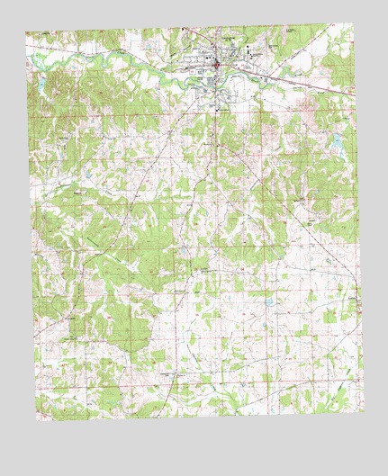
Lexington South, MS USGS Topographic Map
Click on map above to begin viewing in our Map Viewer.

This topographic map contains these locations and features:
Feature Name Type Latitude Longitude GNIS ID View Map
Beulah ChurchChurchN33.0899°W90.0918°667047View Map
Black Watershed Y-36-37 DamDamN33.0901°W90.0051°681840View Map
Bob Gillforth Lake DamDamN33.0385°W90.0418°681803View Map
BrozvillePopulated PlaceN33.0332°W90.1123°667655View Map
Buck CemeteryCemeteryN33.0751°W90.0620°706592View Map
Butterworth CreekStreamN33.0699°W90.1226°667868View Map
Central Holmes AcademySchoolN33.1151°W90.0393°684286View Map
Central Mississippi Female College (historical)SchoolN33.1154°W90.0562°706599View Map
Chestnut Ridge ChurchChurchN33.0265°W90.1084°668379View Map
Chestnut Ridge SchoolSchoolN33.0265°W90.1084°668380View Map
City of LexingtonCivilN33.1163°W90.0497°2404922View Map
Epworth ChurchChurchN33.1079°W90.0523°684297View Map
FranklinPopulated PlaceN33.0360°W90.0020°670157View Map
Galilee ChurchChurchN33.0140°W90.0704°670298View Map
Gourdvine CreekStreamN33.1046°W90.0359°670555View Map
Guy Brown Pond DamDamN33.0901°W90.0001°681839View Map
Hickory Springs CemeteryCemeteryN33.0476°W90.0606°671176View Map
Hickory Springs ChurchChurchN33.0476°W90.0606°671178View Map
Hickory Springs SchoolSchoolN33.0476°W90.0606°671179View Map
Holmes - Humphreys County / Regional Correctional FacilityBuildingN33.1060°W90.0251°2739797View Map
Holmes CountyCivilN33.1235°W90.0921°695749View Map
Holmes County CourthouseBuildingN33.1129°W90.0526°706637View Map
Holmes County Sheriff's OfficeBuildingN33.1060°W90.0248°2754109View Map
LexingtonPopulated PlaceN33.1132°W90.0531°672434View Map
Lexington City Police DepartmentBuildingN33.1165°W90.0534°2754115View Map
Lexington Elementary SchoolSchoolN33.1151°W90.0562°706648View Map
Lexington Fire DepartmentBuildingN33.1148°W90.0531°2665708View Map
Lexington Post OfficePost OfficeN33.1141°W90.0532°2768705View Map
Liberty Grove CemeteryCemeteryN33.0907°W90.1084°672459View Map
Liberty Grove ChurchChurchN33.0907°W90.1084°672460View Map
Liberty Hill CemeteryCemeteryN33.0307°W90.0740°684309View Map
Methodist Hospital of Middle MississippiHospitalN33.1121°W90.0640°706661View Map
Moccasin CreekStreamN33.1082°W90.0493°673721View Map
Newport SchoolSchoolN33.0037°W90.0459°674909View Map
Oak Grove CemeteryCemeteryN33.0923°W90.0701°706666View Map
Odd Fellows CemeteryCemeteryN33.1168°W90.0340°684312View Map
Owens BranchStreamN33.1115°W90.0737°675348View Map
Saints CollegeSchoolN33.0982°W90.0529°684323View Map
Spoll CemeteryCemeteryN33.0340°W90.0779°706694View Map
Springhill CemeteryCemeteryN33.0687°W90.0212°678180View Map
Springhill ChurchChurchN33.0690°W90.0212°678182View Map
Springhill SchoolSchoolN33.0690°W90.0198°678186View Map
Stigler CemeteryCemeteryN33.0779°W90.0879°706695View Map
Sweethome ChurchChurchN33.0871°W90.0545°684324View Map
Tarrey CreekStreamN33.1062°W90.0304°678575View Map
University Hospital and ClinicHospitalN33.1115°W90.0306°2672748View Map
West Grove CemeteryCemeteryN33.0401°W90.0698°679494View Map
West Grove ChurchChurchN33.0401°W90.0698°679495View Map
WLTD-FM (Lexington)TowerN33.1040°W90.0029°680231View Map
WXTN-AM (Lexington)TowerN33.1110°W90.0393°680125View Map

Note: Coordinates in the location and feature list above are referenced to NAD83 datum.


Copyright (C) 2008-2024 Ryan Niemi / Sunset Dynamics ... All Rights Reserved