TopoQuest Logo
Do you find TopoQuest useful?
Help keep TopoQuest running and adding new maps/features by donating!
Bitcoin:  19c7KJd3qBynnjoSw5npx9KScwjBe4ifkT
Litecoin:  LXs6TkuXGGXo1vDsWCkWVdjQX94eUKd6ui
Home View Maps Find Maps Find Places Resources & Links


Teague North, Texas Topographic Map

USGS Map Title: Teague North, TX
USGS Map MRC: 31096F3
DRG (GeoTIFF) Download: o31096f3.tif


Neighboring USGS Topographic Map Quads:


  Wortham, TX  
31096G4
 

  Kirvin, TX  
31096G3
 

  Stewards Mill, TX  
31096G2
 

  Mexia, TX  
31096F4
 

  Teague North, TX  
31096F3
 

  Fairfield, TX  
31096F2
 

  Fallon, TX  
31096E4
 

  Teague South, TX  
31096E3
 

  Dew, TX  
31096E2


Map MRC Location:

N32°
W97°
N32°
W96°
H8 H7 H6 H5 H4 H3 H2 H1
G8 G7 G6 G5 G4 G3 G2 G1
F8 F7 F6 F5 F4 F3 F2 F1
E8 E7 E6 E5 E4 E3 E2 E1
D8 D7 D6 D5 D4 D3 D2 D1
C8 C7 C6 C5 C4 C3 C2 C1
B8 B7 B6 B5 B4 B3 B2 B1
A8 A7 A6 A5 A4 A3 A2 A1
N31°
W97°
N31°
W96°

Teague North, TX USGS 1:24K Topographic Map Preview:
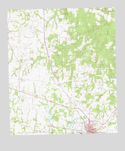
Teague North, TX USGS Topographic Map
Click on map above to begin viewing in our Map Viewer.

This topographic map contains these locations and features:
Feature Name Type Latitude Longitude GNIS ID View Map
Antioch CemeteryCemeteryN31.6404°W96.2861°1351188View Map
Bi-Stone Oil FieldOilfieldN31.6479°W96.3347°1351997View Map
Booker T Washington SchoolSchoolN31.6254°W96.2922°1352675View Map
Burlington-Rock Island Railroad MuseumBuildingN31.6263°W96.2853°2014158View Map
Church of ChristChurchN31.6352°W96.2783°2018796View Map
City Lake DamDamN31.6352°W96.3269°1855591View Map
City of TeagueCivilN31.6296°W96.2803°2412039View Map
Cotton GinPopulated PlaceN31.6810°W96.3605°1355045View Map
Crescent ChapelChurchN31.6266°W96.3253°1355346View Map
Furney-Richardson SchoolSchoolN31.6285°W96.3405°1357806View Map
Gibson ChapelChurchN31.6635°W96.3636°1357997View Map
Gregory FieldParkN31.6296°W96.2911°1358427View Map
Hausler CreekStreamN31.7277°W96.2586°1358899View Map
Hopewell CemeteryCemeteryN31.6613°W96.2950°1359543View Map
Jones LakeReservoirN31.6402°W96.2502°1864130View Map
Jones Lake DamDamN31.6402°W96.2502°1864129View Map
Lower Club LakeReservoirN31.6335°W96.3049°1361906View Map
Lower Club Lake DamDamN31.6302°W96.3069°1855587View Map
Saint Marys Catholic ChurchChurchN31.6279°W96.2814°2018795View Map
Sallie Mounger Elementary SchoolSchoolN31.6299°W96.2769°2005714View Map
Shanks CemeteryCemeteryN31.7324°W96.3311°1368054View Map
SimsboroPopulated PlaceN31.6743°W96.3161°1380546View Map
TeaguePopulated PlaceN31.6271°W96.2839°1376403View Map
Teague City HallBuildingN31.6265°W96.2837°2753608View Map
Teague City LakeReservoirN31.6428°W96.3284°1855592View Map
Teague District Emergency Medical ServicesBuildingN31.6362°W96.2775°2655943View Map
Teague Municipal AirportAirportN31.6631°W96.3097°1387616View Map
Teague Police DepartmentBuildingN31.6264°W96.2837°2739243View Map
Teague Post OfficePost OfficeN31.6270°W96.2842°2731335View Map
Teague Volunteer Fire DepartmentBuildingN31.6279°W96.2837°2552310View Map
Tidus ChapelChurchN31.6282°W96.3347°1369920View Map
Trinity and Brazos Valley Railroad Depot and Office BuildingBuildingN31.6257°W96.2853°2032328View Map
Union Prim ChurchChurchN31.6507°W96.3630°1370467View Map
Upper Club LakeReservoirN31.6404°W96.2981°1370499View Map
Upper Club Lake DamDamN31.6385°W96.3019°1855589View Map
Wesley ChurchChurchN31.6774°W96.2964°1371050View Map
Westside Church of ChristChurchN31.6254°W96.2878°2018797View Map

Note: Coordinates in the location and feature list above are referenced to NAD83 datum.


Copyright (C) 2008-2025 Ryan Niemi / Sunset Dynamics ... All Rights Reserved