TopoQuest Logo
Do you find TopoQuest useful?
Help keep TopoQuest running and adding new maps/features by donating!
Bitcoin:  19c7KJd3qBynnjoSw5npx9KScwjBe4ifkT
Litecoin:  LXs6TkuXGGXo1vDsWCkWVdjQX94eUKd6ui
Home View Maps Find Maps Find Places Resources & Links


Thompson Point, Idaho Topographic Map

USGS Map Title: Thompson Point, ID
USGS Map MRC: 46115G6
DRG (GeoTIFF) Download: o46115g6.tif


Neighboring USGS Topographic Map Quads:


  Little Goat Mountains, ID  
46115H7
 

  Buzzard Roost, ID  
46115H6
 

  Mallard Peak, ID  
46115H5
 

  Bertha Hill, ID  
46115G7
 

  Thompson Point, ID  
46115G6
 

  Sheep Mountain, ID  
46115G5
 

  Headquarters, ID  
46115F7
 

  Browns Rock, ID  
46115F6
 

  Clarke Mountain, ID  
46115F5


Map MRC Location:

N47°
W116°
N47°
W115°
H8 H7 H6 H5 H4 H3 H2 H1
G8 G7 G6 G5 G4 G3 G2 G1
F8 F7 F6 F5 F4 F3 F2 F1
E8 E7 E6 E5 E4 E3 E2 E1
D8 D7 D6 D5 D4 D3 D2 D1
C8 C7 C6 C5 C4 C3 C2 C1
B8 B7 B6 B5 B4 B3 B2 B1
A8 A7 A6 A5 A4 A3 A2 A1
N46°
W116°
N46°
W115°

Thompson Point, ID USGS 1:24K Topographic Map Preview:
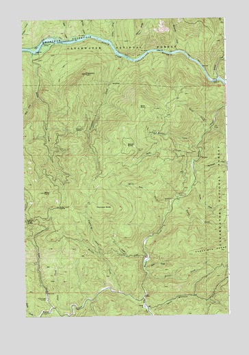
Thompson Point, ID USGS Topographic Map
Click on map above to begin viewing in our Map Viewer.

This topographic map contains these locations and features:
Feature Name Type Latitude Longitude GNIS ID View Map
Beaver ButteSummitN46.8216°W115.6874°377230View Map
Bingo CreekStreamN46.7530°W115.7329°377642View Map
Bingo Creek LandingPopulated PlaceN46.7571°W115.7368°397440View Map
Bingo SaddleGapN46.7907°W115.7490°377643View Map
Bonner CreekStreamN46.7674°W115.6751°378021View Map
Butte CreekStreamN46.8613°W115.7438°378602View Map
Butte Creek LandingLocaleN46.8646°W115.7382°397508View Map
Butte Creek SaddleGapN46.7955°W115.7288°378605View Map
CampLocaleN46.7541°W115.6776°378751View Map
Charlie CreekStreamN46.8041°W115.6485°399824View Map
Cooper CreekStreamN46.7760°W115.6760°379671View Map
Doyle CreekStreamN46.7707°W115.6776°380744View Map
East Fork Beaver CreekStreamN46.7582°W115.6776°381047View Map
Falls CreekStreamN46.7546°W115.7213°381568View Map
Hanson SaddleGapN46.8230°W115.7182°393976View Map
Harlan CreekStreamN46.7602°W115.6938°382911View Map
Idaho CreekStreamN46.8152°W115.6465°383601View Map
Isabella CreekStreamN46.8491°W115.6307°383775View Map
Isabella LandingPopulated PlaceN46.8496°W115.6290°397813View Map
Kauffman SaddleGapN46.8282°W115.7185°399941View Map
Lightning CreekStreamN46.7752°W115.7049°384631View Map
Marquette CreekStreamN46.8613°W115.6563°386475View Map
Micky PointSummitN46.8019°W115.7382°386778View Map
Milk CreekStreamN46.8657°W115.7227°386907View Map
Montana CreekStreamN46.8227°W115.6424°387095View Map
Old Camp JLocaleN46.8271°W115.6690°387924View Map
Salmon CreekStreamN46.8657°W115.6985°389850View Map
Sheep Mountain CreekStreamN46.7538°W115.6765°390246View Map
Sourdough CreekStreamN46.8149°W115.6454°390842View Map
Sousie CreekStreamN46.8007°W115.6535°390847View Map
Sousie Creek CampgroundLocaleN46.7999°W115.6560°395964View Map
Steep CreekStreamN46.8294°W115.6354°391412View Map
Swan PointSummitN46.8380°W115.6796°398206View Map
Syringa CreekStreamN46.8680°W115.7127°397234View Map
Thompson ButteSummitN46.7955°W115.7010°398237View Map
Thompson CreekStreamN46.8591°W115.6877°392031View Map
Thompson PointSummitN46.8521°W115.7127°392043View Map
West Fork Butte CreekStreamN46.8427°W115.7418°393063View Map
White Pine CreekStreamN46.7985°W115.6604°393357View Map

Note: Coordinates in the location and feature list above are referenced to NAD83 datum.


Copyright (C) 2008-2025 Ryan Niemi / Sunset Dynamics ... All Rights Reserved