TopoQuest Logo
Do you find TopoQuest useful?
Help keep TopoQuest running and adding new maps/features by donating!
Bitcoin:  19c7KJd3qBynnjoSw5npx9KScwjBe4ifkT
Litecoin:  LXs6TkuXGGXo1vDsWCkWVdjQX94eUKd6ui
Home View Maps Find Maps Find Places Resources & Links


Thorntown, Indiana Topographic Map

USGS Map Title: Thorntown, IN
USGS Map MRC: 40086B5
DRG (GeoTIFF) Download: o40086b5.tif


Neighboring USGS Topographic Map Quads:


  Mulberry, IN  
40086C6
 

  Frankfort, IN  
40086C5
 

  Michigantown, IN  
40086C4
 

  Colfax, IN  
40086B6
 

  Thorntown, IN  
40086B5
 

  Mechanicsburg, IN  
40086B4
 

  Shannondale, IN  
40086A6
 

  Hazelrigg, IN  
40086A5
 

  Lebanon, IN  
40086A4


Map MRC Location:

N41°
W87°
N41°
W86°
H8 H7 H6 H5 H4 H3 H2 H1
G8 G7 G6 G5 G4 G3 G2 G1
F8 F7 F6 F5 F4 F3 F2 F1
E8 E7 E6 E5 E4 E3 E2 E1
D8 D7 D6 D5 D4 D3 D2 D1
C8 C7 C6 C5 C4 C3 C2 C1
B8 B7 B6 B5 B4 B3 B2 B1
A8 A7 A6 A5 A4 A3 A2 A1
N40°
W87°
N40°
W86°

Thorntown, IN USGS 1:24K Topographic Map Preview:
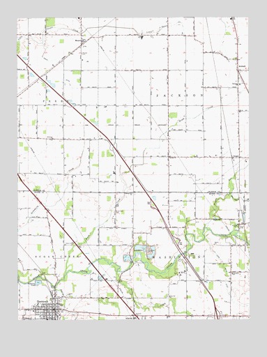
Thorntown, IN USGS Topographic Map
Click on map above to begin viewing in our Map Viewer.

This topographic map contains these locations and features:
Feature Name Type Latitude Longitude GNIS ID View Map
AntiochPopulated PlaceN40.2281°W86.5058°430198View Map
Bethel Hill CemeteryCemeteryN40.1345°W86.5444°430953View Map
Brush CreekStreamN40.1442°W86.5989°431679View Map
Brush Creek CemeteryCemeteryN40.1695°W86.5725°431682View Map
Clark Airport (historical)AirportN40.1945°W86.5231°449172View Map
Garden ParkParkN40.1270°W86.5625°434945View Map
Gipson CemeteryCemeteryN40.1567°W86.5947°435090View Map
Harr Wills DitchCanalN40.1409°W86.5131°435771View Map
Kinder ChurchChurchN40.1923°W86.5431°437314View Map
MansonPopulated PlaceN40.2400°W86.5903°438535View Map
Manson CemeteryCemeteryN40.2351°W86.5900°438536View Map
Maple Lawn CemeteryCemeteryN40.1253°W86.6164°438569View Map
Midstate Aggregate PitMineN40.1539°W86.5586°2649593View Map
Nagle DitchCanalN40.2309°W86.6003°439926View Map
New Hope ChurchChurchN40.2000°W86.6061°440068View Map
Oxidation PondReservoirN40.1405°W86.6142°440820View Map
Pleasant Hill ChurchChurchN40.1775°W86.5628°441280View Map
Prairie CreekStreamN40.1387°W86.6050°441549View Map
ReaganPopulated PlaceN40.1920°W86.5094°441809View Map
Reagan RunStreamN40.1634°W86.5239°441810View Map
Spring CreekStreamN40.1481°W86.5747°443972View Map
ThorntownPopulated PlaceN40.1295°W86.6067°444737View Map
Thorntown Police DepartmentBuildingN40.1292°W86.6067°2758355View Map
Town of ThorntownCivilN40.1293°W86.6101°2397695View Map
Township of JacksonCivilN40.2172°W86.5064°453437View Map
Township of WashingtonCivilN40.1342°W86.5270°453983View Map

Note: Coordinates in the location and feature list above are referenced to NAD83 datum.


Copyright (C) 2008-2025 Ryan Niemi / Sunset Dynamics ... All Rights Reserved