TopoQuest Logo
Do you find TopoQuest useful?
Help keep TopoQuest running and adding new maps/features by donating!
Bitcoin:  19c7KJd3qBynnjoSw5npx9KScwjBe4ifkT
Litecoin:  LXs6TkuXGGXo1vDsWCkWVdjQX94eUKd6ui
Home View Maps Find Maps Find Places Resources & Links


Tie Plant, Mississippi Topographic Map

USGS Map Title: Tie Plant, MS
USGS Map MRC: 33089F7
DRG (GeoTIFF) Download: o33089f7.tif


Neighboring USGS Topographic Map Quads:


  Holcomb, MS  
33089G8
 

  Grenada, MS  
33089G7
 

  Kincaid, MS  
33089G6
 

  Jefferson, MS  
33089F8
 

  Tie Plant, MS  
33089F7
 

  Duck Hill, MS  
33089F6
 

  North Carrollton, MS  
33089E8
 

  McCarley, MS  
33089E7
 

  Eskridge, MS  
33089E6


Map MRC Location:

N34°
W90°
N34°
W89°
H8 H7 H6 H5 H4 H3 H2 H1
G8 G7 G6 G5 G4 G3 G2 G1
F8 F7 F6 F5 F4 F3 F2 F1
E8 E7 E6 E5 E4 E3 E2 E1
D8 D7 D6 D5 D4 D3 D2 D1
C8 C7 C6 C5 C4 C3 C2 C1
B8 B7 B6 B5 B4 B3 B2 B1
A8 A7 A6 A5 A4 A3 A2 A1
N33°
W90°
N33°
W89°

Tie Plant, MS USGS 1:24K Topographic Map Preview:
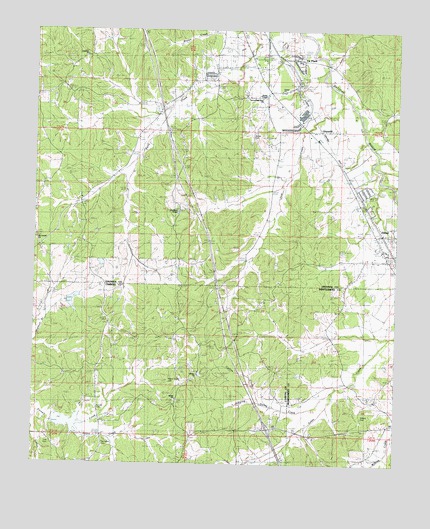
Tie Plant, MS USGS Topographic Map
Click on map above to begin viewing in our Map Viewer.

This topographic map contains these locations and features:
Feature Name Type Latitude Longitude GNIS ID View Map
Bethel CemeteryCemeteryN33.6429°W89.8276°666886View Map
Bethel CemeteryCemeteryN33.7212°W89.8026°666887View Map
Bethel ChurchChurchN33.6435°W89.8270°666937View Map
Bolton BranchStreamN33.7062°W89.7543°683050View Map
Calvary CemeteryCemeteryN33.6507°W89.8201°667925View Map
Calvary ChurchChurchN33.6504°W89.8198°667942View Map
Calvary SchoolSchoolN33.6498°W89.8237°667952View Map
Collins Gulley CreekStreamN33.6462°W89.7720°668705View Map
Elliot ChurchChurchN33.6868°W89.7562°669733View Map
Elliott Baptist ChurchChurchN33.6915°W89.7548°683064View Map
Elliott Census Designated PlaceCensusN33.6913°W89.7525°2586591View Map
Elliott Church of ChristChurchN33.6915°W89.7531°683065View Map
Elliott Volunteer Fire DepartmentBuildingN33.6912°W89.7547°2665894View Map
GlenwildPopulated PlaceN33.7210°W89.7820°670438View Map
Grenada Fire Department Station 3BuildingN33.7354°W89.7972°2665940View Map
Hardiman CemeteryCemeteryN33.6982°W89.8276°670902View Map
Hardiman ChapelChurchN33.6985°W89.8279°670903View Map
Interchange 195CrossingN33.6351°W89.7940°691448View Map
Jack CreekStreamN33.7326°W89.7704°683083View Map
Jumping CreekStreamN33.6426°W89.7979°672055View Map
Lott CemeteryCemeteryN33.6312°W89.8712°672888View Map
New Hope Second Baptist ChurchChurchN33.7304°W89.7981°677491View Map
Old Salem CemeteryCemeteryN33.6304°W89.8529°675247View Map
Payne Chapel CemeteryCemeteryN33.6493°W89.8295°675519View Map
Potacocawa Structure Y-31a-34 DamDamN33.6718°W89.8568°682291View Map
Potacocawa Watershed Y-31a-13 DamDamN33.6368°W89.8701°682260View Map
Primitive ChurchChurchN33.7429°W89.8579°683101View Map
Purnell CemeteryCemeteryN33.6401°W89.8551°676420View Map
Salem CreekStreamN33.6357°W89.8648°677296View Map
Simpson (historical)LocaleN33.7121°W89.7704°683106View Map
Supervisor District 1CivilN33.7127°W89.8505°711863View Map
Tie PlantPopulated PlaceN33.7415°W89.7901°678754View Map
Tie Plant Elementary SchoolSchoolN33.7412°W89.7843°705801View Map
United ChurchChurchN33.7329°W89.7904°683114View Map
Wesley ChapelChurchN33.7310°W89.7998°679452View Map
Wilkins CemeteryCemeteryN33.6448°W89.7562°679689View Map
Wilkins ChapelChurchN33.6443°W89.7568°679691View Map
Williamsville ChurchChurchN33.6896°W89.8709°679728View Map

Note: Coordinates in the location and feature list above are referenced to NAD83 datum.


Copyright (C) 2008-2024 Ryan Niemi / Sunset Dynamics ... All Rights Reserved